
The summer of 1967 was an exciting time for me. I was working on a geological exploration crew in the Stikine. Where’s that, you might wonder. Think far northwestern British Columbia, Canada, snug up against the Alaska Panhandle and the Yukon Territory. It was considered a pretty remote area back then. Only one road penetrated the area – it ran south from the Yukon and ended at the village of Telegraph Creek about 250 hard miles later. Our camp sat just west of Yehiniko Lake, and when I say it was in the boonies, I’m not kidding. We built our own camp in a clearing about 1,500 feet from the shore, and there we lived from late May to early September.
It was a magical place, this Stikine. The area was named for the Stikine River, which drained a heavily-glaciated 20,000 square miles. It was unspoiled and exciting. Our crew of about a dozen guys spent our days flying around in a helicopter, generally pretending to look busy by prospecting and looking at stuff. The whole place was teeming with wildlife and mosquitoes. I loved it, and was just plain giddy from being in such a spectacular area.
On a typical day, the chopper would take off from camp and head to a pre-designated spot, often high on a ridge or a mountain-top. We always worked in pairs – the two of us would agree on a pickup point with the pilot, and meet him there in the valley bottom at the end of the day. Then came the exciting part – armed with ice axes and crampons, we would make our way down, sometimes dropping several thousand feet over the course of a long day. Often, the only good spot where the pilot could pick us up would be on a sand bar in the middle of a creek or river. It wasn’t boring. Some days, we’d do it all in reverse, getting picked up on the top after climbing all day.
As the summer progressed, I really got into it. Nothing excited me more than a day spent moving through the mountains- up, down or sideways, it all worked for me. We didn’t always do single-day outings such as I’ve described. Sometimes the chopper would fly two of us and a lot of food and gear, enough for up to two weeks, out to a very remote spot. It would drop us off and leave us to our own devices. The idea was that we would make day trips out in every direction from camp, prospecting and collecting samples. When we had done all we could from there, a call to base camp at Yehiniko would earn us a chopper ride back. It always felt good to be there, where our cook whipped up good food and we could drink beer with the others.
As the summer progressed and we explored more of the area, one big peak really caught my eye. A mere 13 air miles from our base camp, in a south-southwesterly direction, sat Ambition Mountain. It was a real beaut, master of all it surveyed. It towered 9,688 feet above sea level and couldn’t help but impress, no matter the angle. It was surrounded on all sides by glaciers. In fact, even late in the season, it was covered in snow and ice, with little exposed rock.
On July 31st, a Cessna on floats landed on our lake. After a short while, it took off and soon returned to land again. It unloaded some men and a pile of gear. None of them came over to our camp to visit, but they did camp on the shore the one night. I figured they were climbers. The next morning, they set out on foot with huge packs, heading upstream along Yehiniko Creek towards the glacier that spawned it. We never saw them again.
I had been twisting my boss’s arm for some time, and he finally cried “Uncle!”. He said that if I picked a partner, and we promised to at least pretend to look at a few rocks en route, he would agree to let us use the chopper to make an attempt on Ambition. Murray was agreeable to be part of this, so, on August 6th, he and I piled into the chopper with day packs, ice axes and crampons. In a short few minutes, the pilot flew us the 13 miles over to the mountain. He had his mountain-flying certification and was good at what he did, but nevertheless he wanted to be really cautious. He preferred to land us down low on the glacier, at about 6,500 feet. He said he’d pick us up later at the same spot, and away he flew.
It was early in the morning – this far north, the summer days are very long, so we had broad daylight at an early hour. There we were, standing on the ice with the whole day ahead of us. Have a look at this website, which has as fine a set of photos of the mountain as you’ll ever hope to see. If you scroll down through the pictures, you’ll come to one labeled “Ambition South Face”. That is the best one for me to use to describe our route. I’ve taken the liberty of copying that photo here for you.
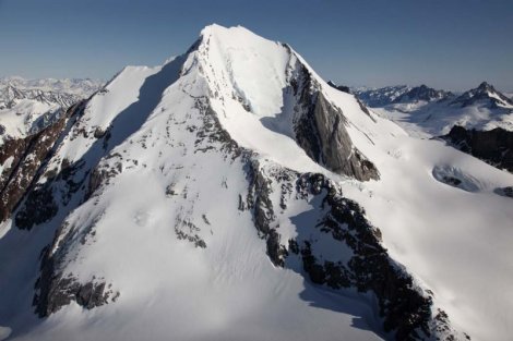
We were young, foolish and in pretty good shape after a summer of hard physical work in the mountains. Back to the picture – see the rock rib starting on the lower right – that’s what we went up. It was mixed rock and snow, but not too difficult. After some time, we got up to a more open area, flatter, about half-way up in the photo. This shows as a large snowy area. From there, our route continued more steeply up the rib which angles from right to left. One of my strongest memories is the roar of almost-non-stop avalanches rushing down the snow slopes on either side of our rib.
At about 8,700 feet, we made a major stop to eat and rest. Although we still had a thousand feet to go, it seemed like we were gonna do it. Setting out again after a while, we continued up. Near 9,100 feet, our path up the ridge was blocked by a large gendarme. The drop-off on either side was severe, and scared the crap out of us. We had reached an impasse – our lack of experience had caught up with us. We simply didn’t know how to get around it with our very small bag of tricks. Dejected, it didn’t take us long to chicken out and call it quits. It was a long, slow descent, over 2,500 vertical feet down to our pick-up point. It went without incident, and, at the appointed hour, the unmistakable sound of the approaching chopper signaled the end of our adventure.
Once on board, we asked the pilot if he had any problem with flying up the route we had followed that day, just so we could have one last look. He said that’d be fine, so up we went. Within minutes, he reached our high point. We could see the gendarme in front of us as we hung there in space. Then, as we continued up past it, we saw two sets of footprints in the snow, plainly visible as they continued upwards. It was easy to follow them the last 600 feet, where they stopped on the summit.
So, it all fell into place. Our mysterious visitors in the Cessna had walked up to the headwaters of Yehiniko Creek, crossed some glaciers, then ascended by the same route we had chosen. The difference between them and us was obviously their greater experience. Sure, we had made it to within 600 feet of the summit, but it might as well have been 6,000. Woulda, coulda, shoulda. There seems to be some confusion as to when Ambition Mountain was first climbed, or even if it has ever seen an ascent. Well, I can say beyond any shadow of a doubt that it was summitted by two climbers around August 3rd to 5th, 1967. Let the record so state.
You can also visit us at our Facebook page at: https://www.facebook.com/pages/Desert-Mountaineer/192730747542690