
“Climb the mountains and get their good tidings. Nature’s peace will flow into you as sunshine flows into trees. The winds will blow their own freshness into you, and the storms their energy, while cares will drop away from you like the leaves of Autumn.”
― John Muir, The Mountains of California
For weeks, we had been talking about it, trying to arrange a day that would work for both of us. Then Andy called and said he’d like to come with, so that was it, we would be three. The agreed-upon Saturday arrived. Per our usual crazy hot-weather routine, Jake parked his car at my place at 2:00 AM, we put everything into the truck and drove off into the night. A setting full moon lit our way, and an hour and a half later, we met Andy at the Vekol exit. He was going to try and drive his car south for eight miles or so, then hop in the back of the truck. The wash crossings were unkind, however, and he only made it five.
It was still pitch-black as we motored on, Andy trying to get comfortable in the back. At first, the dirt roads weren’t too bad, but after a few miles, they went to hell in a handbasket. Recent rains had made some spots much rougher – very high clearance was a must. By the time we parked, the pavement had been left two hours behind. The days are getting shorter, so when we started walking, at 5:37 AM, it was just light enough to navigate.
It felt muggy, due to recent rains and higher humidity. Even so early, we started sweating while walking up the gentle wash. It wasn’t long before we started to see large yellow caterpillars, thousands of them, covering bushes along our path. Here is a picture I took which shows them everywhere. Jake researched these and discovered that they are white-lined sphinx, and will become huge moths. The link takes you to a fascinating page that tells all about them, well worth reading.

We continued to see these for a long while – it seemed like they’d be a great food source for hungry desert creatures. A feature we were looking forward to seeing along our path, shown on the topo map, was a waterfall. In the desert, these aren’t usually labeled on maps unless they’re very obvious. This one did not disappoint, with a clear drop of at least 40 feet. There was no way we could climb it, so up and around we went.

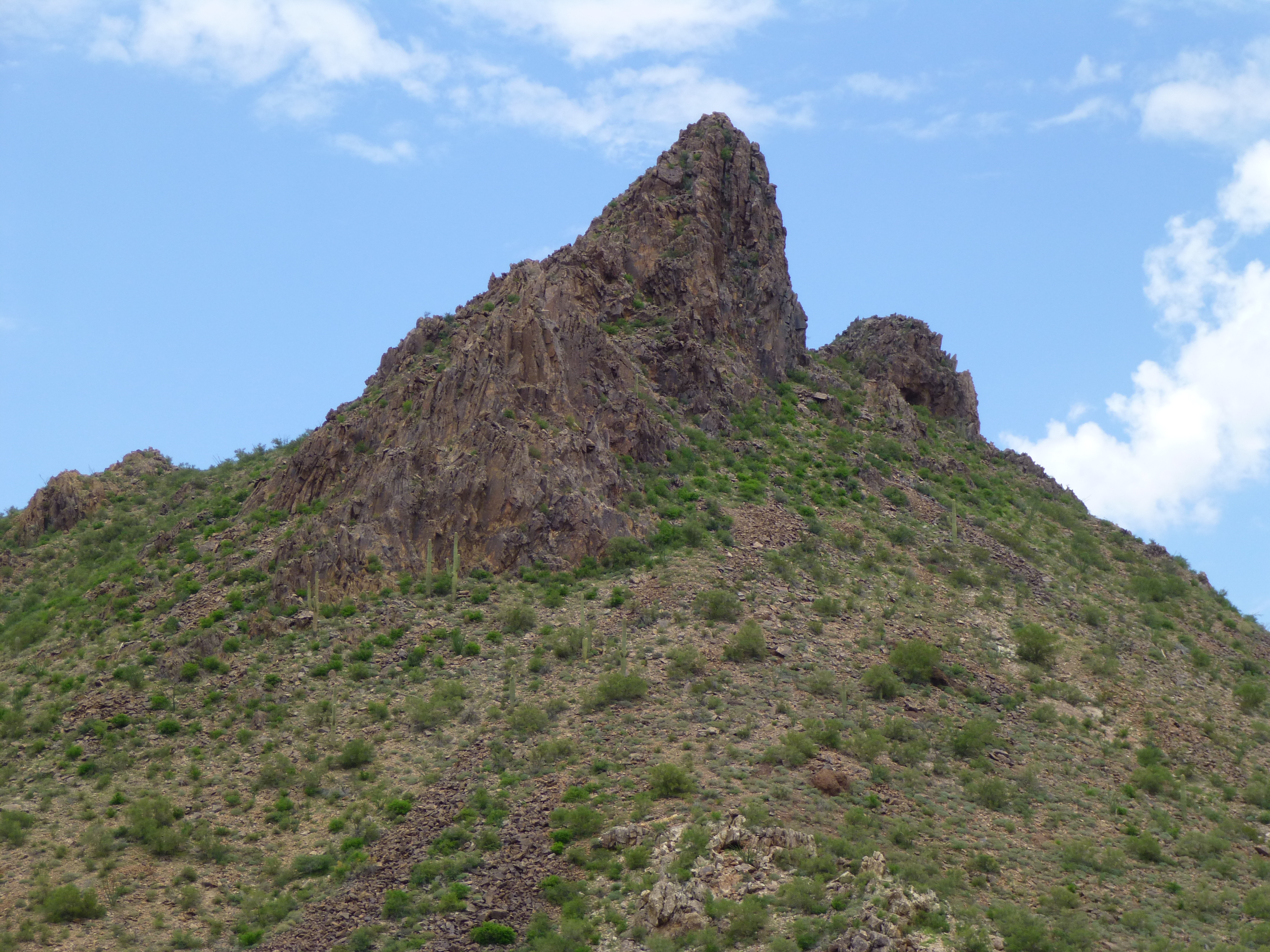
That put us on a higher level of the wash, and as we continued, we had a great view of our goal, what we were calling Peak 3940.

Climbing another 600 vertical feet brought us to a saddle just west of the peak, where we stopped to take stock of our situation. The reason we were here today was to not only climb the peak but also to try to get a good idea of its height. For the past several weeks, we had been studying the summit area by various means – new and old topographic maps, satellite photos and photos we had ourselves taken from different angles. So far, we had proven that it was higher than shown on the current map, but how much higher? – we didn’t know, but hoped today to do some measuring and find out once and for all.
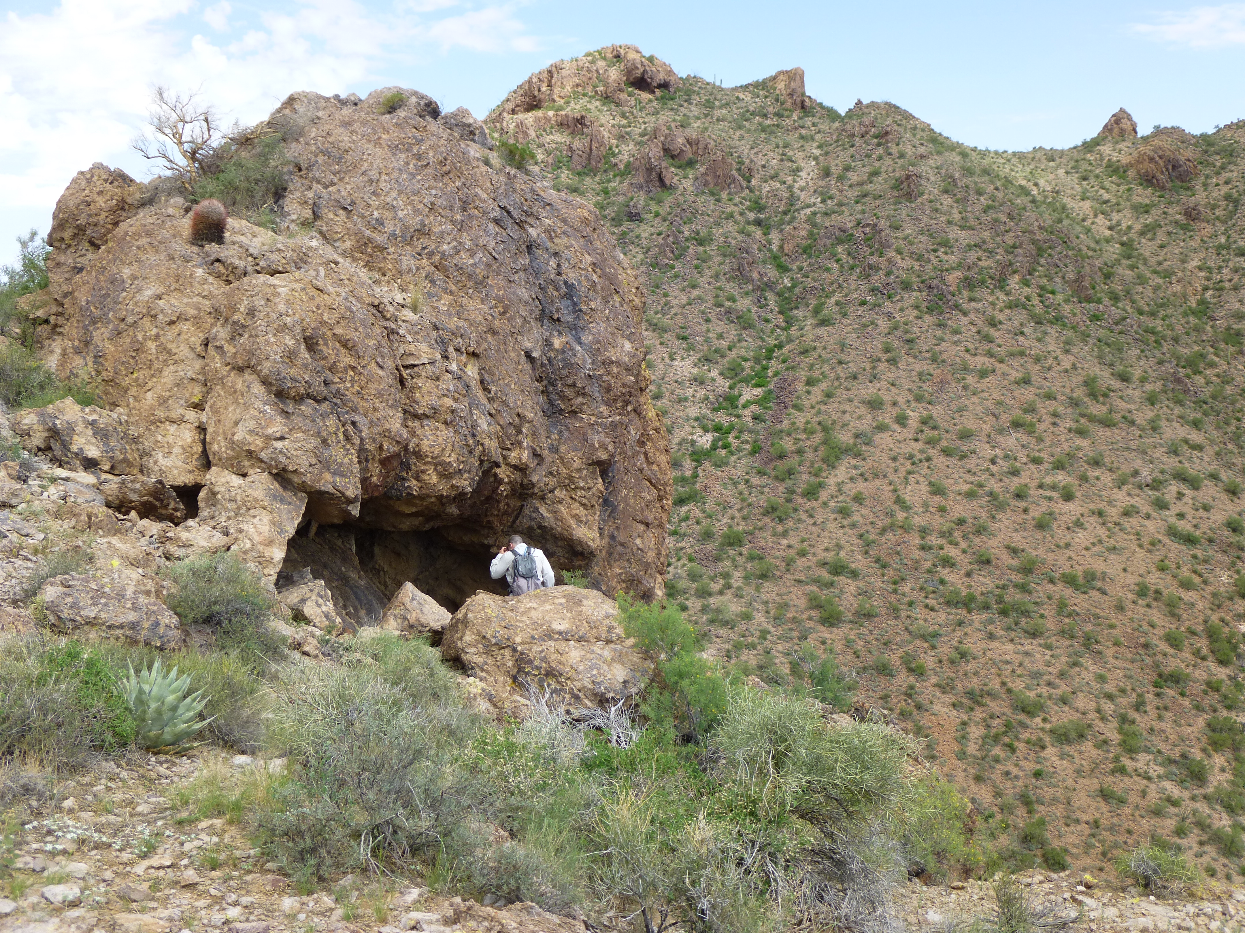
So how to start? Well, to the west of the saddle rose a rocky bump with a spot elevation of 3,908 feet. We excitedly made our way over to a smaller outcrop on the way, and as we neared it, something caught our eye – a prominent cave, with an odd formation inside it. Here is what we saw.

There were hundreds of these rounded depressions in the ceiling and back wall, from one to six inches across. At first, we wondered if they had been made by insects, or maybe birds or bats. Upon closer inspection, they turned out to be of solid rock. We couldn’t figure out what had caused them, but the cave would make a terrific shelter from any storm.
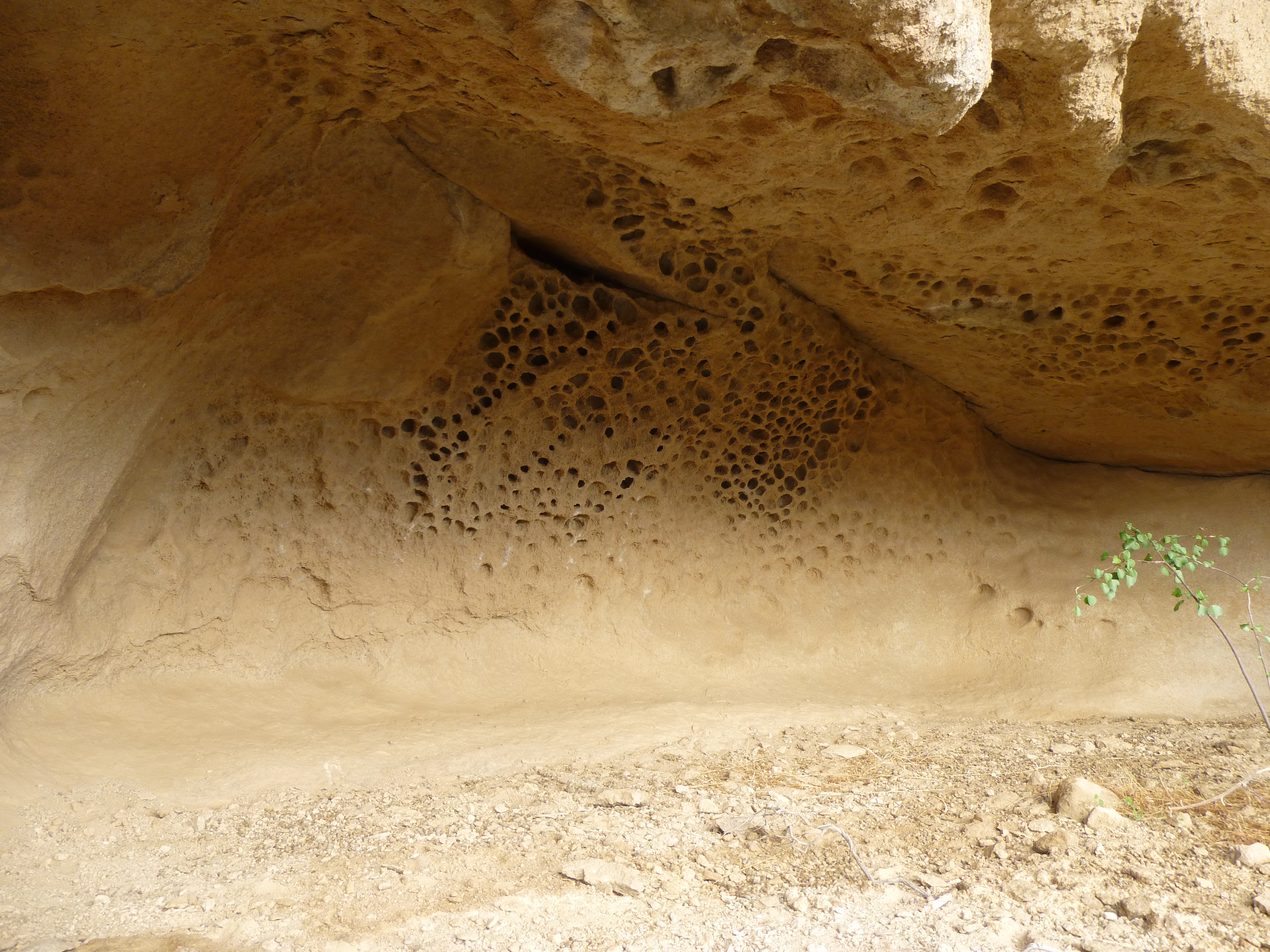
The cave
After a few minutes there, we left and moved on, climbing to the top of Point 3,908. It was a rounded area with a spectacular view. Why were we here? – this wasn’t the peak we had come to climb. We needed a starting point, something we could take as gospel. If the surveyors or map-makers had given this bump an elevation as specific as 3,908 feet, we felt they had good reason for having done so, and that was good enough for us.

Sitting a bit below the top, we took out my 5-power surveyor’s hand level. It has a bubble and a set of lines for centering. Sighting through the level, I focused on a spot on the peak to the east, the one we had come to climb. Doing that five times and always coming up with the same spot, I then gave it to Andy and Jake to try – they both concluded that that was our spot all right, the spot that was the same elevation as our Point 3908. While we were doing all that, we heard a noise – it was a chopper. It took a while to pinpoint it, but we finally did, over to the northeast close to Squaw Tit. Here’s a telephoto shot, the only one we got. If you zoom in, you can see the markings on it, those of the Arizona Game and Fish Department. It flew farther south, close to where the truck was parked, then moved west and spent a while flying around the summit of Dragon’s Tooth. What I would have given to be flying around the Tooth with them!
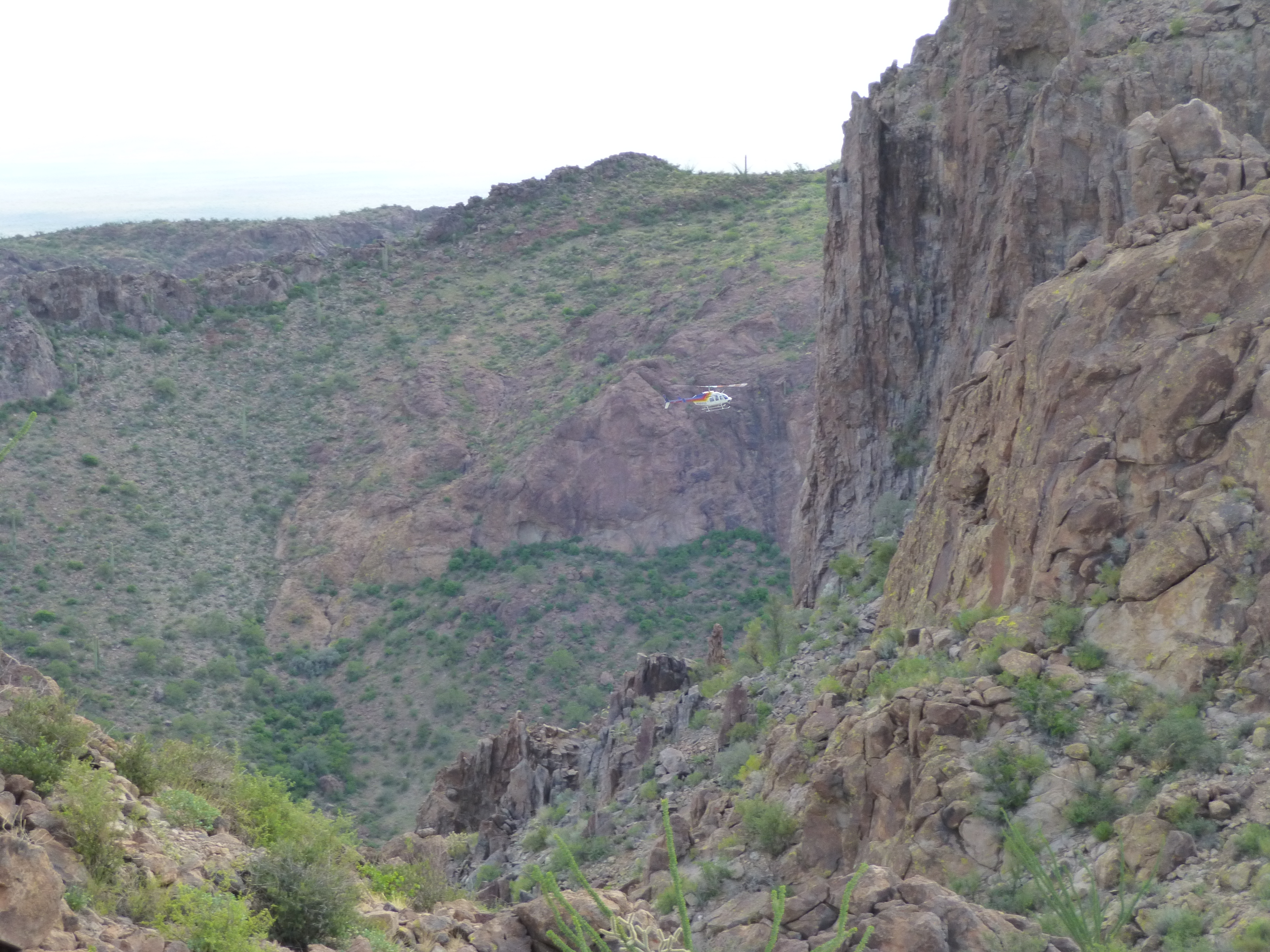
The helicopter
That done, we made our way back down to the saddle, then climbed up to our chosen spot on the other mountainside. Once there, we marked it. So now what?
We felt strongly that we now had the 3,908′-level on our peak. Taking out a measuring tape we had brought, and using the hand level, the three of us slowly and carefully made our way up the west side of the peak, measuring as we went. Dang, this thing was a whole lot steeper than we expected. Finally, we reached the summit ridge. Narrow and exposed, Jake and I even did a few feet of au cheval just before the summit, and there we were. Here’s the view looking back south from the top, along the ridge, which drops off into space a few feet later.

Our measurements gave us a final elevation of 3,965.2 feet above sea level, and it had been fun doing it. We feel our margin of error isn’t more than two feet. Like all of these peaks in the Sand Tanks, the summit was untrodden, and this one was a solid Class 3. We soaked up the view, left a register and took lots of pictures. Our work was done here, so we very carefully started down. I felt the steepness even more on the descent. Perhaps 75 feet below the summit, Andy found a cave entrance. We checked it out and found that the floor dropped very steeply – in fact, down and right through the mountain to come out on the other side. Here’s Andy sitting inside, and you can see almost vertically down past him to the slope on the other side of the mountain.

This was way too interesting to ignore, so we decided to drop down and find the nearest place to get around the north side of the peak and find the lower end of the cave. It took some climbing to find it, but we did and, as we stood in the cave entrance, here was the amazing view looking out.

This day was bringing one surprise after another, and we were having a great time. After an all-too-short spell in the cave, we made our way back around the mountain and to the saddle where all today’s fun had started. Our paths continued together for a while yet, down to the even lower key saddle from which our new peak’s prominence was measured. Beyond that, we climbed up on to a ridge, where we split up. Andy wanted to climb another peak, one that Jake and I had done six weeks earlier, so off he went to do that while we continued down the ridge.
Jake’s nosing around online had uncovered something curious in the area, what looked like a tank meant to hold water. But for what purpose – it was in such an odd spot. Dropping off the ridge, we started down a canyon and found it, right where the satellite imagery said it would be. Here’s the first thing we saw.

It was a stone wall, cleverly-made in this remote location. Vertical steel pipes had been set into the native rock, then long horizontal ones had been wired to them. Sturdy wire mesh had been wired on to all of that, in such a way to create a cage that had been then filled with thousands of stones. More mesh covered the whole affair, making it very strong. Water flowing down the canyon could easily pass through the wall, but any debris could not. It soon became apparent why.
Below the wall in the narrow canyon, two concrete barriers had been built. These could have only been put there for one reason, to provide water for wildlife in this harshest of lands.

The wall kept the tanks from filling with debris, to prevent them from getting silted up and becoming unable to hold water. These were still working very well – the water was quite deep, perhaps five feet or even more. Every drop was precious. While we were there, we saw many bees, butterflies and dragonflies drinking. Even better, Jake noticed hordes of tadpoles swimming around, and hundreds of tiny toads hopping around the edges. He picked up one of these micro-toads while I took his photo. They were all exactly the same size, and impossibly cute. Jake’s research shows these are likely Mexican spadefoot toads.

As we marveled at all of the neat stuff at these tanks, Jake told me to smile, then pointed to this, which was sitting on a rock ledge nearby. It was a motion-sensor camera placed by the Department of the Interior, U.S. Fish and Wildlife Service, no doubt to keep track of thirsty animals coming to drink.
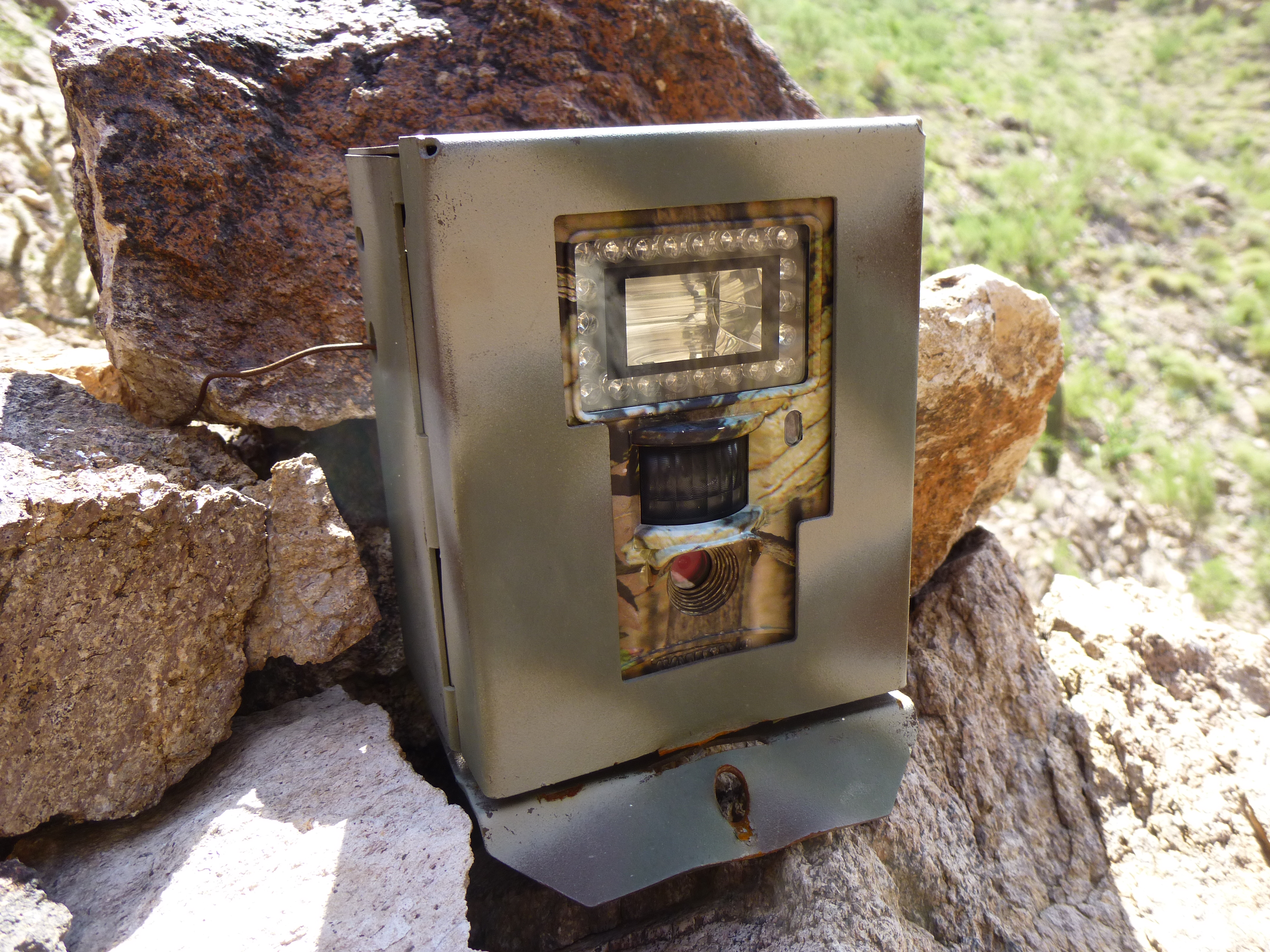
Motion-sensor camera
Cemented to the rock wall above the pool was this marker. It answered at least one of our questions – the tanks had been built as a collaborative effort by Luke Air Force Base, the U.S. Fish and Wildlife Service and the Arizona Game and Fish Department back in February of 1987. They had even given this spot a name – Juniper Tank.
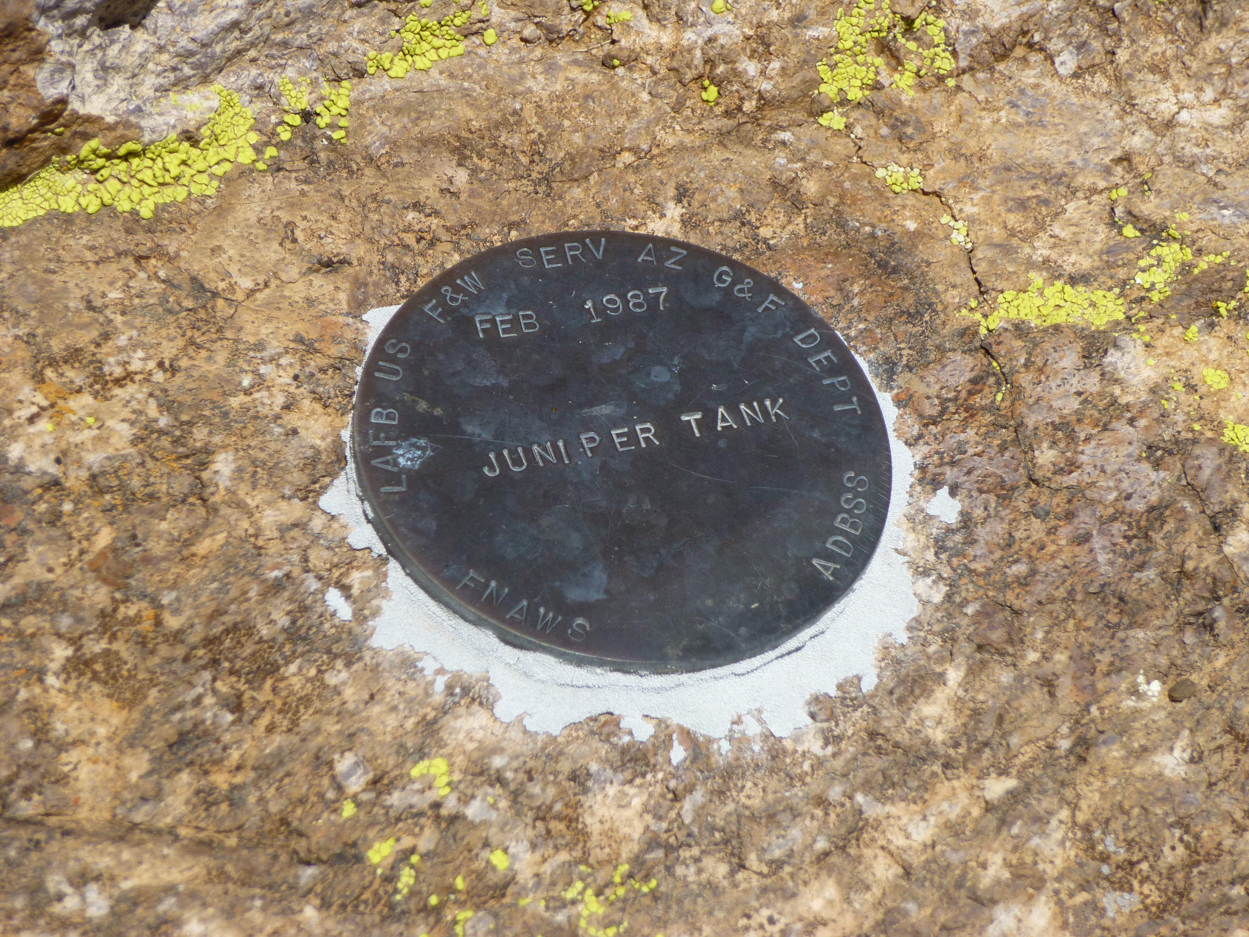
Juniper Tank marker
The day had treated us pretty well so far, with a fair amount of cloud cover helping keep the temperature down. But we still had miles to cover, so decided it was time to book it. Making our way back up to and over the wall, we started up an easy slope. Minding our own business, suddenly we heard a familiar noise – rattlesnake! It’s a good thing we’d heard it, as we almost stepped on it – a little one, maybe 18 inches long. It slithered under a bush and out of sight of our cameras, but moments later a much larger one came into view. It didn’t rattle, and moved directly towards us, not afraid at all. It was at least three feet long. Jake later learned that they were both black-tailed rattlesnakes.
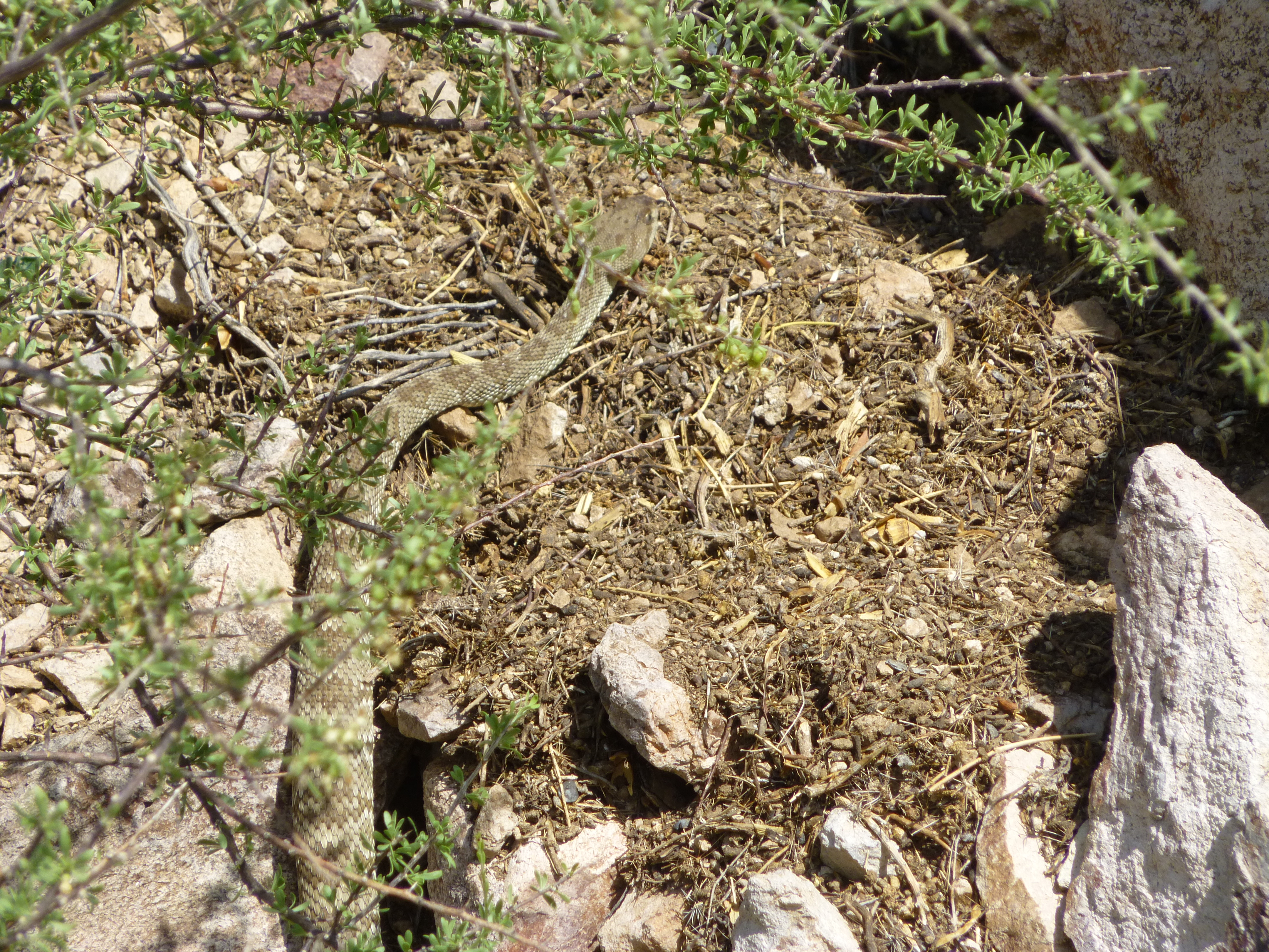
Black-tailed rattlesnake
After that bit of excitement, we continued up to a ridge. Andy had successfully climbed his peak, and was still on top of it when we called him on our two-way radio at the agreed-upon time. He said he’d start down right away and meet us on the ridge where we waited. Jake had found another nearby cave and went to check it out, while I ate some lunch and admired the view.
Jake’s cave. Andy’s peak was behind the highest bump on the center skyline
The Sand Tanks don’t disappoint, that’s for sure. Before long, Andy joined us and we three dropped down to meet our earlier ascent route, just above the waterfall. From there, we had this last view of our new peak climbed earlier in the day. This is looking north, directly up the south ridge. Our ascent route was up the left slope to gain the ridge, then directly away from the camera to the summit.
Looking north to our new peak
Our wash was somewhat brushy from the waterfall back to the truck, but we dispatched it fairly quickly. The day was still somewhat overcast, so that helped. By the time we finished, it was just after one o’clock – seven and a half hours total time for our day. Even the weather had cooperated – it was a cool 94 degrees in the shade. On the very bumpy drive out to Andy’s vehicle, his ride in the back was “not bad at all” – he was able to get situated on some cushions, and with the rear sliding window open in the cab, I could blast some AC his way. We got him back to his car, still parked where we had left it almost eleven hours earlier. No encounters with anyone out there today – no Border Patrol, no indocumentados – just wildlife. Our study and climb of the new peak went well, just as we had hoped. Gotta love those Sand Tanks – there’ll be many more challenging days out there yet.
Please visit our Facebook page at: https://www.facebook.com/pages/Desert-Mountaineer/192730747542690