
One of my favorite ranges in Arizona is the Baboquivari Mountains. They lie southwest of Tucson, and much of the range can be seen from parts of the city. Although it spans only 28 miles, it contains many peaks, several of them technical in nature. Two of them were on my hit list – I could see them from town, and every time I did, the urge grew to go visit them. I finally gave in, and on February 25, 2004 I set out.
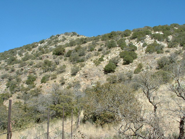
Fifty miles of driving on pavement took me to a junction, where I drove another 9 miles on good dirt roads across ranch lands to park by a locked gate at 8:40 AM. It was permitted to continue beyond the gate, but not by driving. I had a good view of the two peaks on my agenda for the day. In this photo, the higher of the two is just left of center; the lower is the gently-sloped one on the right.
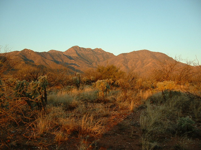
Peak 6403 on the left; Peak 6411 on the right
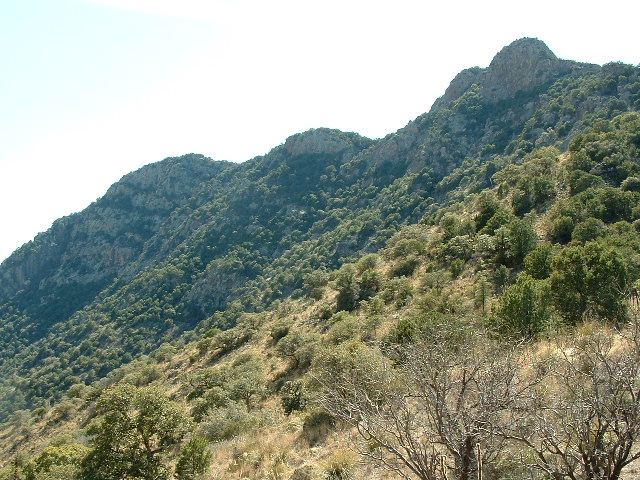
I readied my pack for a long day, lifted my mountain bike over and rode away, heading gently uphill for two miles. The map showed a spot where the road became a “jeep trail” and it was there I stashed the bike, elevation 3,680 feet. By now, I was well up into Contreras Canyon. The next photo was taken an hour and a half after the first one as I pedaled up the road. It shows Peak 6403 and its long summit ridge – the high point is the bump on the left end of the ridge.
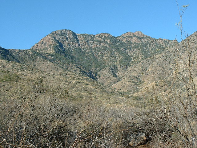
Getting closer to Peak 6403
This next photo is the view from the spot where I stashed the bike. After a long day of climbing, I’d need to find this spot again.
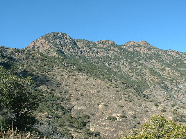
The view from the end of the road.
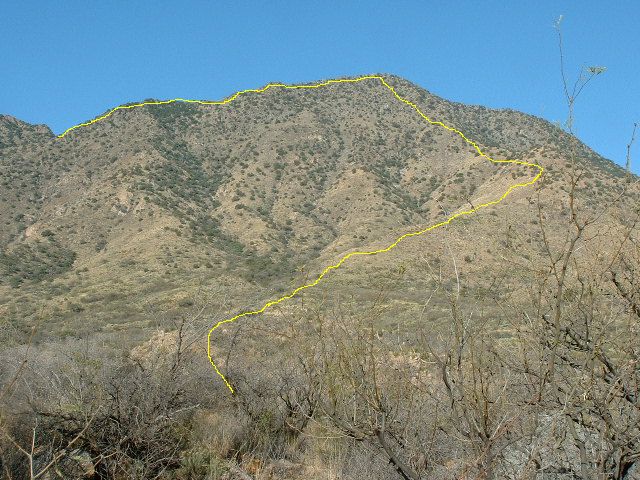
It felt good to finally be on foot, and after a short while along a cow path I reached the foot of a slope where I started a long, steady climb southwest up a ridge to finally reach a distinct bump at 5,400 feet. This was good, almost 2,000′ climbed since leaving the truck. From there, I followed a fence line to the northwest over several annoying bumps – that done, I stood 100 feet lower, at 5,300′, and was staring up another ridge. There, 600 feet above me, stretched a band of cliffs across much of the mountainside. If I were to go straight up the ridge, I’d run right into the worst-looking part of them, so I chose to traverse south away from the ridge and outflank them. I didn’t gain as much elevation that way but it was worth it (I even ran into 2 deer on the way). Even so, there were some Class 3 moves involved to put me above the cliffs at 5,800 feet. From there, I worked straight north up the final slope to reach the summit of Peak 6403 just before noon. See the next photo – as the yellow line comes into the picture from the left edge at 5,400′, it heads right and drops down to 5,300′. It then abruptly turns left and climbs 1,100 vertical feet to the summit.
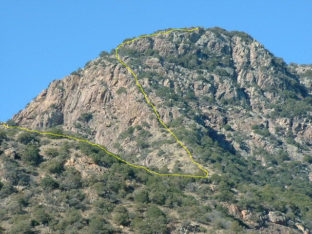
The last part of the route to the top of Peak 6403
This was a really cool mountaintop – wooded, with a bunch of bumps. I looked around for a bit before I found the highest spot, and there was the register. It had been left by Paul Pixler on 3-17-92, but he mentioned three prior entries he had seen in what was left of an older register, from 1972, 1978 and 1990. After Paul’s entry, there was only one other – Mark Nichols and Richard Joseph had signed in on 2-13-99. Five years the mountaintop had sat, quietly awaiting its next visitor. I signed in and continued the cycle. Here’s a view looking 3,000 vertical feet down to the desert below – my bike and my truck are both down there somewhere.
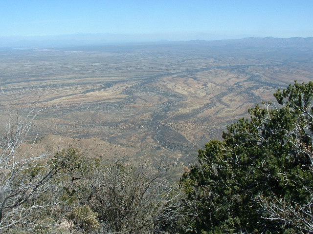
Looking east from the summit.
Three miles away, to the southwest, stood two peaks in stark relief. Here’s a telephoto shot of them.
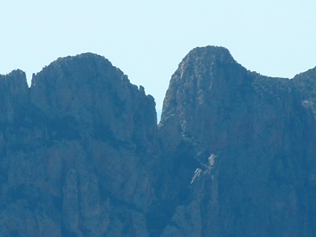
The Ugly Sister on the left; Peak 6328 on the right.
History would show that Brian Rundle would go on to lead masterful first ascents of both of these peaks. Here’s an interesting fact for you: there are about 7,500 peaks in Arizona, and if you look at the steepness of all of them, Peak 6328 is the 29th-steepest of the lot, and The Ugly Sister is the 15th-steepest. There is some extremely vertical real estate in that photo, and the drop-offs from both of them are breathtaking and terrifying if you’re on either end of a rope up there.
After a very enjoyable half-hour of lunch and contemplation, I continued. My idea was to head north along the ridge all the way over to another peak – it was a good way off, but I thought that since I’d already made the effort to get this high and far, I might as well finish the job. Almost half a mile farther along the ridge was a substantial bump, elevation 6,375, which I needed to cross – it was only 28 feet lower than the summit. Notice the very steep drop-off beyond, over to the right – that will become important later.
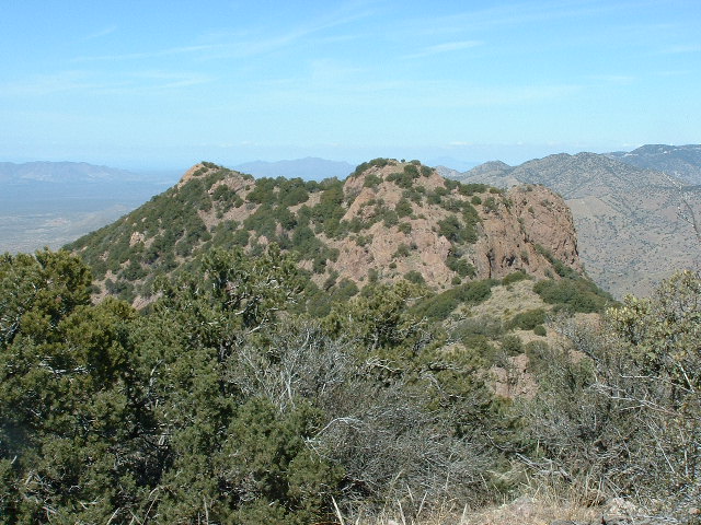
From the summit, looking NNW to Point 6375
When I had climbed Point 6375, I started down the other side and lost about 200 vertical feet when I came to an obstacle I couldn’t overcome – a sheer cliff blocked my way, and it wrapped around both sides of the ridge. Damn, I was stuck. I was wishing I had a length of rope so I could rappel down the 20-or-so vertical feet of the trickiest bit. There was nothing for it but to climb back up to the top of Point 6375 and try another way down. Well, it was my lucky day – I saw a steep gully dropping to the northwest, a dark place untouched by the winter sun. Down I went, grappling with a dense thicket of small trees and, much to my surprise, snow. It was thigh-deep in places, but it was a welcome diversion. The wall of cliffs on my right forced me down, lower and lower, so that by the time I regained my ridge I was all the way down to 5,700′. What a relief to finally be back on easy ground again. When I reached the low saddle at 5,565′, the one between my two peaks, it was 2:00 PM. Survey marker #5 delineating the eastern boundary of the Tohono O’odham Indian Reservation was there, having been installed way back in 1926.
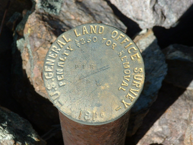
The survey marker in the saddle
From the saddle, I could see the path ahead, up the south ridge of my next peak.
Looking up the south ridge of Peak 6111
I could also look back up to Peak 6403, where I’d just been. This photo shows the multiple bumps along its summit ridge. The cliff that stopped me can be seen on the far right end.
Looking back up to Peak 6403
Anxious to make up for lost time, I hustled up the slope and by 2:40 was on the top of Peak 6111. The register showed that the peak had been climbed 3 times before, in ’91, ’99 and ’01. Of all the entries in this register and the one on Peak 6403, Bob Packard was the only other climber who had put in the effort to climb them both on the same day. Bob was 66 years of age when he did this, and I was 56. It was a beautiful afternoon and I was in no hurry to leave, but as much as I enjoyed the summit, I knew I had to go – the days are short at this time of year, and I still had a long way to go.
My plan was to make my way down the mountain and get back to my bicycle – this is always a fun challenge, navigating your way over new ground to reach a precise point without wasting a lot of effort. To begin, I dropped a thousand vertical feet down the easy north-northeast ridge, then I turned southeast and lost almost another thousand to reach the faint upper end of that old jeep track I mentioned early in this story. Well, I found it all right, then walked it down another 500 vertical feet to my bike, right where I’d left it. Man, that felt good. The next photo shows my route up and then down Peak 6111.
The route on Peak 6111
It was all over but the shouting. It had taken the whole day to describe a huge loop around the entire drainage of Contreras Canyon. The last part was easy, coasting downhill for two miles on my bike – I reached my truck at around 4:40 PM, almost 9 hours after I’d left it. It had been a great day climbing this nice pair of peaks.
Please visit our Facebook page at: https://www.facebook.com/pages/Desert-Mountaineer/192730747542690