
There are 740 peaks within the boundaries of Pima County, Arizona, although I didn’t know that for sure until a few years ago. It’s a pretty large area, 9,189 square miles, about the size of the U.S. state of New Hampshire. My great adventure to climb all of those peaks started way back in 1986, but at that time I didn’t even know it. Much of that year was spent trying to figure out which mountain was the highest in each of Arizona’s 15 counties, and then heading out to climb them. Even that list was modified several times over the years as new information became available. There was no doubt about Pima County’s highest, though – at 9,157 feet, Mt. Lemmon towered over metro Tucson. I discovered early on that it was a stealth climb – you had to sneak inside the fenced astronomy compound that enclosed the summit area. An opening in the east side of the chain-link fence provided the way. The Steward Observatory grounds covered a bit of a rise in the road that marked the highest point.
In 1987, my attention had turned to a much larger project. Climbing the county high points had started me thinking about all of the great-looking mountain ranges I was seeing as I traveled around the state. I wondered how many of them there were. Try as I might, I couldn’t find any list that named them all, so I decided to create my own. Untold hours spent in the map library at Arizona State University, poring over 1,800 topographic map sheets, showed that there were 193 different named ranges in Arizona. Since I was doing all that work already, it made good sense to locate the highest point of each range and put that information on the list too.
Making the list wasn’t just for fun, it also created a new list of peaks for me to climb. Once I started down that road, the project developed a life of its own. Having made the decision to climb the range high points, I became more deeply committed to completing the project. Sometimes I was gone from home for weeks at a time, living out of the back of my pickup. By the end of 1989, it was done – every peak was climbed, with no exceptions. 43 of those range high points happened to be within Pima County, so without even knowing it, I had crossed a few more off of the Pima County list.
By the summer of 1987, I had moved to Tucson. Realizing that I was surrounded by a large array of peaks, I started climbing everything I could in the eastern part of the county near my home. Still, I had no specific plan to climb all of the peaks in the county, I was just having fun. A major turning point came in 2001 when my friend Dave Jurasevich came out from California and suggested we do a bit of peakbagging on the nearby Tohono O’odham Indian Reservation. Five days of climbing there got me another dozen or so, but more importantly, I started to think seriously about all of the peaks out there on the reservation.
Back in the day, you could get a permit to climb on the reservation. I kept mine current, and I’m glad I did, as law enforcement often asked to see it when they met me in the back-country. The TOIR encompasses a large area, 4,375 square miles, about the size of the state of Connecticut. Another friend, Andy Bates, had meticulously created a list of all of the peaks on the reservation, all 401 of them. He did that back in the day before computer software had become available to figure those things out for you. What a list it was! It intrigued me, and I often found myself looking at it in my Terrain Navigator program once I had installed Andy’s file. The reservation was an ancient land, untouched by climbers – over a period of several years, I left over 350 registers on its peaks and met some amazing people. On March 18, 2006 I climbed my final peak out there, in the company of close friends.
By now, it was easy to see that it wouldn’t be too much of a stretch to try to climb all of the remaining peaks in Pima County. Many of them, out in remote areas like the Cabeza Prieta National Wildlife Refuge, Organ Pipe Cactus National Monument and the Barry M. Goldwater Air Force Range would involve a lot of hard work – long distances on foot into wilderness areas with no water sources, things like that. There were some epic trips that resulted from the madness that now had me in its grip – outings like the six days spent in the Agua Dulce Mountains along the Mexican border where we found human remains; nine days in the remote and barren Granite Mountains, where a friend and I had to each carry a hundred pounds, most of it water, just to survive (let alone climb 18 peaks); backpacking solo into the northern Growler Mountains to pick up eight more, in the process running face-to-face into 4 smugglers carrying loads of drugs. There were many more adventures such as these, all necessitated by my philosophy that when you climb the peaks on a list, you climb them all, period, no exceptions, regardless of how difficult or prohibited they might be. Speaking of difficulty, some of these were classic desert first-ascents, which would never have been possible without the skilled and determined leadership of technical climbers such as Brian Rundle and Andy Bates.
The last couple of years spent on the project were mostly in ranges such as the Growler Mountains, which is now completely over-run by members of a Mexican drug cartel. When the back-country of Organ Pipe Cactus National Monument was re-opened to the public recently, I was free to go in and spend long days among its amazing peaks, climbing the ones that had been off-limits for a dozen years. That set up a flurry of activity in ranges such as the Bates Mountains, the Sonoyta Mountains, the Puerto Blanco Mountains, the Sierra de Santa Rosa and the Ajo Range. More human remains, more scary run-ins with drug cartel lookouts – yes, those were dramatic moments, but they were offset by amazing days spent in canyons and on ridges that had been seldom visited by humans.
I have been fortunate to observe wildlife such as deer, javelina, bighorn sheep and Sonoran pronghorn antelope in their natural settings. Fortunate, also, to have saved the lives of a few desperate border-crossers who had lost their way and were dying in the desert.
As the peaks were ticked off of the list of the 740 within Pima County, I realized that enjoying the journey was more rewarding than arriving at the destination. Eventually, the day came when there was but one remaining, an easy one I’d left for last, one where a few friends could join me on those final steps to a final summit. Congratulatory e-mail wishes came from friends far away who couldn’t be there in person, from such places as Canada, Mexico, Turkey, Japan, Australia, Argentina, England, Switzerland and around the USA. But on January 16, 2016, there were 18 who did arrive at the visitor center at Organ Pipe Monument. Friends from Tucson and Phoenix in Arizona, half a dozen from California and, much to my surprise and delight, my old friend and climbing partner, Brian Rundle, who had come all the way from Michigan. We convoyed out to a parking area, then set out as a group. Not much more than an hour later, we stood on top of Peak 2306 in the Puerto Blanco Mountains, and it was done. It was bittersweet. Sure, there was a warm, fuzzy feeling for having finished, but all the fun of the planning and execution was over.
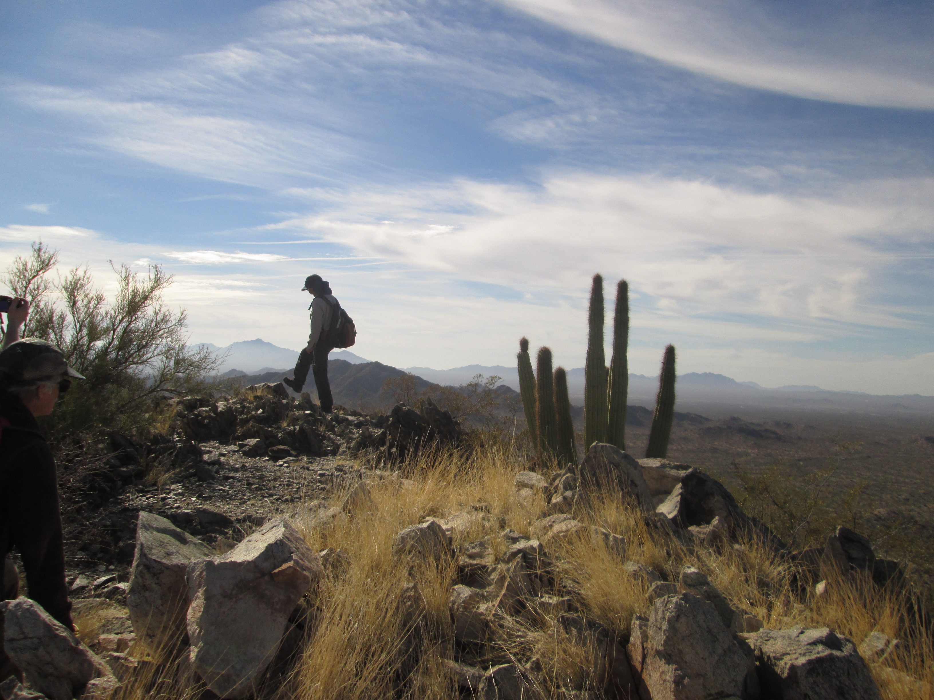
Taking that last step on the final peak
I think I can safely say, knowing the area as I do, that nobody will ever attempt to repeat climbing the 740. It’s just too dangerous. If anyone were to ask me if they should give it a go, I’d let them know, in no uncertain terms, that it’d be a fool’s errand. It’s simply not worth the risk to life and limb.