
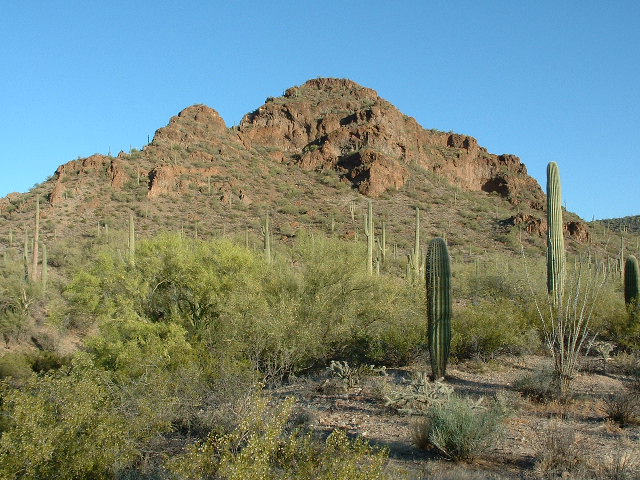
A long time ago, apparently many years before any other climbers went in to climb there, I visited a mountain range in south central Arizona called the Cimarron Mountains. It sits squarely inside the Tohono O’odham Indian Reservation, in a quiet area where no-one lives. Some of the TO cattle have wandered through there, but the only real sources of water for them in the area are man-made water-holes in the Chui Tontk Valley on the west side of the range, and a few to the north near the Pinal County line. Only a few works of man indicate that humans were ever in the range at all, and those are in the form of mines worked long ago – we’ll get to those later.
From a climber’s point of view, access to the range’s peaks isn’t too bad, keeping in mind that some of the roads have badly deteriorated, to the point that parking and then continuing on foot may be the only way to approach some of the peaks these days. There are 3 main ways to approach the peaks in the range, as follows (I’ll discuss all 3 of those approaches in detail as I discuss the peaks themselves):
- From Indian Highway 15 on the east side.
- From the northeast via roads in Kohatk Valley, which are in turn approached from Indian Highway 42 near the village of Kohatk.
- From roads that head out of the village of Ventana, on the west side of the range.
It’s been a long time now since I first ventured into the Cimarron Mountains (the name is Spanish, and denotes a maroon color). It was on June 9th of 1989 when I first went in. In retrospect, going there in June was slightly insane, as the daytime temperatures are guaranteed to be well over 100 degrees. If you drive Indian Highway 15, about half a mile south of milepost 21 is a wire gate and cattleguard on the west side of the road. That’s your ticket in – start driving west on the very flat road, and go 4.9 miles until you reach a Y junction. In those miles, you’ll only have gained 330 feet of elevation, and find yourself at 2,000 feet above sea level. Take the right-hand fork at the Y, and you’ll notice a definite deterioration of the road from that point on. Persist for another 3.2 miles and you’ll reach the vicinity of the New Ore Mine. This mine is a curious one. It operated briefly sometime before 1949. Mineralization was willemite and associated calcite that fluoresces red and green when exposed to short wave UV light. A small tonnage of this material was shipped to California for use in fluorescent fireplaces. Anyway, this is as close as you could ever drive to Peak 3145, which is the highest point in the range. About a dozen climbers are known to have made the trip in there, and the only reason they went there is that the peak is the range high point. Otherwise, it is a nondescript bump that wouldn’t attract any attention. From where I parked, to the summit and back was a round-trip of only about 2.5 miles and involved 925 feet of climbing. There is another way to approach this peak, and that is via roads from the north through Kohatk Valley. It is 11.5 miles one-way compared to 8.1 miles the way I did it.
Truth be told, there was only one reason I went in and climbed Peak 3145 in the first place – it was the high point of a range. Back in the 1980s, I was working feverishly to complete a project I had dreamed up – to climb the highest point of each of Arizona’s 193 mountain ranges, and that peak was on the list. Once it was climbed, I basically forgot all about the range and moved on to other things. That changed, though, in 1991 when climber friend Dave Jurasevich put the idea in my head that there was plenty more climbing to do in Pima County and maybe I should get on with the business of doing it. After he and I climbed the high points of all of the named groups of hills on the reservation, he sort of cast me adrift to pursue what would then become the biggest project yet – climbing all of the 400 peaks on the reservation, then all of the 740 peaks in Pima County. Holy crap, that would take years! Oh well, there was nothing for it but to get started.
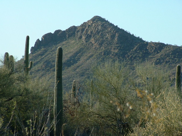
By the time 2003 rolled around, I was deeply involved in the 400-peak project and found myself once again considering the Cimarron Mountains, as they were nearly all on the reservation. An overview of the range had me puzzling over its boundaries, especially on its northern flank – where did the range end? After much deliberation, I decided that Osity Benchmark was part of the range – it was an easy climb from an old road on its north side, and that took place on June 25th, another insanely hot summer day.

Looking south to Osity Benchmark
A few weeks later, I went back in, this time to climb Copper Benchmark. This peak lies about 3 miles north of the village of Ventana and is easily approached from a road on its west side. Foothills in the northwest part of the range approach this peak and come right up to it, making it clearly a part of the Cimarron Mountains, in my humble opinion. This climb was done on July 13th, another scorcher. After the climb, I encountered 7 indocumentados riding bicycles north along that west-side road, in broad daylight – that was an eye-opener.
Another year passed, and I wanted to head back into the range to climb more of its peaks. Using option 3 outlined earlier, I drove west from Highway 15. It was May 12th of 2004, and I knew it’d be another hot day requiring an early start. From that junction 4.9 miles in, this time I took the left fork of the Y. I was able to drive another 2 miles, but the road was deteriorating, and one spot south of the Drew Spring Well was so bad I could barely make it through in 4wd. A wash has eaten its way across most of the road and you cannot get through it with all four wheels on the ground at the same time. A few years after I was there and that will be as far west as you can go unless some serious road repairs are done. And that will never happen, as there is no reason to justify the TOIR’s spending such money, as the road ends only a few miles later beyond Montazona Pass. I parked a short distance west of the Blackjack mine, then headed northwest on foot up a major un-named wash. It was a beautiful morning, still cool and pleasant.
Walking up the wash was like taking a highway – it was wide, sandy, and there were
birds singing everywhere. After a few miles, I left the wash and went directly up the southeast slope of Peak 2948.

Peak 2948 to the northwest
I was only a mile away from the Cimarron Mountains high point, but that was not an objective for today. I built a cairn, and took a register out of my pack. After I had filled in my information on the paper, I put it in the jar which I then stashed in the cairn. My plan was to climb three peaks before returning to my truck, so I left this first summit and then headed down its sinuous southwest ridge. Once I reached the wash at its base, it was a pretty straightforward climb up the north ridge of Peak 2970.
Peak 2970
As before, I didn’t see any sign left by anyone who may have come before me, so I built a cairn and left the requisite register – that’s something I never tire of doing. Next, I followed the southeast ridge to drop off the peak. It seemed like a good idea to keep following the ridge, which described a large arc taking me east, then northeast to finally arrive at the top of Peak 2930.
Peak 2930 from the north
From this group of three summits in the northern part of the Cimarron Mountains, you get a great view west to all of the Castle Mountains, and can easily see all the way from the Window Mountain area in the south to the village of Ventana in the north. Once I had spent a while admiring the view, it was time to take my leave. Carefully making my way down from the summit, I regained the big wash and enjoyed the walk back to my truck. Once there, I drove east back to that junction, then headed north up the road which I had used to get to the range high point years before. I didn’t go far, though, and stopped near the old Montazona Mine. This one had been worked back in 1920 and had produced some copper, lead, silver and gold.
It was getting really hot by then, as it was nearly noon. On the east side of the road, I headed part way up the mountain on a very old road which ended at some prospects, then up through cholla-infested slopes to the summit of Peak 2784. Register placed, I headed down the steep western slopes to my truck. By noon or 1:00 pm, the heat is becoming challenging. I was lucky to get four peaks done before I had to call it a day. Turning on the air conditioning, I cranked the fan up to maximum. It’s amazing how, no matter how hot you’ve become while out climbing, that blast of cold air makes you feel almost human again. I knew I wouldn’t need to return to this area, but it had been a really great day – the scenery was terrific.
So now that I was on a roll when it came to this range, what was next? Ever the glutton for punishment, I decided to return 5 weeks later and tackle a couple more. On June 19th, I drove in from the Kohatk Valley northeast of the range. From where I crossed the county line near Benchmark 1908, it was another 4.9 miles to reach Salt Well (now dry), and then another mile to where I parked near Point 2246. A quick climb to the northwest brought me to the top of Peak 2830, where there was no sign of any previous visit, so I left one.

Looking west to Peak 2830
Back at my truck, I drove back to Salt Well and parked for my next peak. It was a mile and a half to the top of Peak 2873 to the southeast, another virgin summit.
Peak 2873. We are looking south. I used the ridge on the skyline on the right side.
Well, that was it, I was finished with the Cimarron Mountains, there was no need to go back. Or so I thought. Thirteen years later, I was exploring the Copperosity Hills to the north of the range when I decided that a small peak near the Greenback mine was a contender. The mine had operated until 1939 and had produced some gold, silver and copper. Just south of the mine sat Peak 2510. I climbed it via some gritty rock and took more of a chance doing it than I should have – it was one of those climbs where you think back on it and it makes your palms all sweaty again. The south side descent was easy, which I learned afterwards. It was June 8th of 2017. Over at the mine, I came upon a terrifying shaft that was 688 feet deep at a 50-degree incline. Just looking down it was enough to put the fear of God into anybody.
Peak 2510, the north side
Okay, now I could say that I had visited all of the peaks in the range. That little project had spanned almost 30 years, but I got to see some pristine country in the doing. To this day, aside from the range high point, the Cimarron Mountains have been ignored by other climbers. The only exception is one other peak, which saw a single ascent by another climber. Man alive, talk about untouched country!