
It was 1989, it was June, and it was hotter than the hinges of hell here in the Arizona desert. The forecast for the place I was going to today was a high temperature of 109 degrees F. – that’s pretty insane, even for the old Desert Mountaineer. I was 6 months away from completing another project, that of climbing the highest point of each of Arizona’s 193 mountain ranges. Today, it was the turn of the Sierra Blanca, a small range in the heart of the Tohono O’odham Indian Reservation.
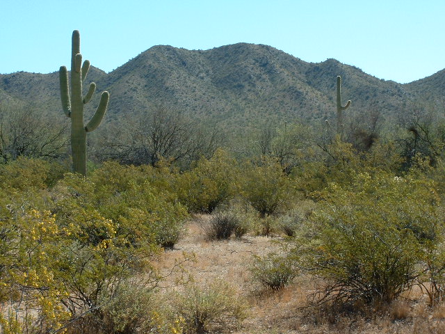
The Sierra Blanca is one of those ranges that everyone has seen. It literally starts on the shoulder of Highway 86 and goes north from there. Anyone who has driven between the towns of Ajo and Tucson in Arizona has looked at the high, narrow ridge that forms the spine of the range. It is rocky, and light in color as seen from a distance, hence the name.
The day I went there, I knew I had to start really early because of the killer heat, so by first light I was already in the area. But where to park? Looking around, I found an old dirt road that left the pavement about a thousand feet west of the site of an old settlement called Stoa Vaya on the USGS topo map. The proper O’odham name is S-toha Wawhia. This means “White Well” in the O’odham language. The faint road took me about a mile north, where I expected to find an even fainter road which, in theory, headed over to and then up the ridge to the summit. Guess what? I couldn’t find the even-fainter road, but if I had, I’d have tried to drive up it, just for fun.
Once I’d parked and prepared my pack, I set out from 2,450′ elevation. This was way back before there was GPS, back in the day where we had to use good old-fashioned orienteering to make our way through the mountains. Although I felt I could do that as well as the next guy, I still couldn’t find that faint road, but with a GPS unit I could’ve nailed it. I had no other choice but to head west, cross-country, towards the ridge. It was messy and convoluted, but after a while I got over to Point 2663 way down at the south end of the ridge.Now all I had to do was to keep heading north towards the summit. Easier said than done. There were so many bumps to go over (I counted at least 12 significant ones) that it soon started to get old.
Once the sun rose, things heated up quickly. Thankfully, I found the faint road after crossing the third bump, and was able to follow it for a mile and a half until it fizzled out, but that was a big help. My total walk along the ridge was almost 3 miles, made all the more tiring with all those bumps to cross and the increasing heat. What a relief to finally reach the highest point – it was named Rabia Benchmark, at 3,727′ elevation. It was too hot to stick around and enjoy the view, so I left a register and started back down quickly.
On my return trip down the ridge, I was glad to pick up the old road again, and this time, I was able to follow it all the way down to my vehicle. The round trip had taken just under three hours, covering 7.1 miles, and even though I was done just before 9:00 AM, it was approaching 100 degrees in the shade. Dangerous heat – I had dodged a bullet.
I stepped into my time machine and traveled 16 years into the future. On April 10th of 2005, the weather was unseasonably cool. They predicted a high of around 70 degrees for both Saturday and Sunday, about 10 degrees below normal. I thought it would be a perfect time to head back to the Sierra Blanca.
On Sunday morning, I got up early and drove in the dark. I arrived at San Simón on the western side of the reservation when it was daylight. San Simón is the Anglo name for the village of Wohg Hudunik, which shows up on Anglo maps as Wahak Hotrontk. It means “Road Dip”, probably because the huge San Simón wash comes through there. The land in the area of the village is very flat and is prone to flooding in the rainy season. Although the village is home to only 125 souls, it is important, because it serves a large area of the western reservation. It has a high school (the kids get bused a long way) and they are building a large health clinic there. Not a soul was stirring when I opened the wire gate on the north side of AZ highway 86 across from the village.
This was an area that was unfamiliar to me. I passed a water tank, then continued north on a good dirt road which was obviously well-traveled. After about 4 miles, I arrived at North Tracy’s well. Here, I needed to pick up a road heading east. The start of it was very vague, and I found myself driving around through brush and becoming very frustrated. By using the GPS, I worked my way further south and, lo and behold, there was the road. It was a good one, and it too looked recently travelled. Making good progress, I headed east. After a few miles, I crossed under an electrical transmission line, which was wooden poles with electrical wires. It is shown on the map, so wasn’t a surprise, but there was an excellent dirt road paralleling it – I knew this would come in handy later. I continued on to the road end at a large man-made tank, and a set of nice corrals. This was 4 miles from North Tracy’s Well. I parked and got my pack ready. By the time I left, it was not yet 8:00 AM.
I headed east across the desert. You can imagine my surprise when, not 1/4 mile from where I’d parked, I came upon an abandoned vehicle. It was a Chevy Blazer, left there so recently that the tags were still good until June of 2005. It was parked on a very faint old road not shown on the maps. It was up on blocks, as if someone had removed a wheel to make repairs. The tail lights had been covered with black tape. Was that so they couldn’t be seen from behind as they tried to avoid law enforcement? These abandoned vehicles have usually been stripped of anything useable, as was this one.
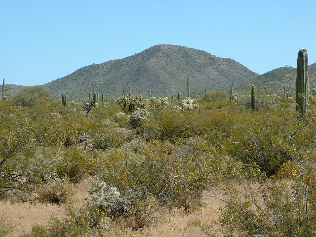
I carried on and soon arrived at my objective, Peak 2890. There are only three summits in the Sierra Blanca, and this was the middle one. It sits 2.5 miles NNW of Rabia benchmark, known to a few of us diehards, of course, as the high point of the Sierra Blanca. On the summit, I built my typical cairn and left a register. When I sign in to each of the registers I leave out on the res, I draw a triangular symbol with “TOIR” written below it and inside the triangle a number which indicates how many I have now climbed on the list of reservation peaks. This one was number 302.
Peak 2890 from the west
I descended the mountain by its west ridge and crossed the desert floor to my truck, then drove west back to the power line and followed it north. The road was so good I could do 30 mph at times. After 4 more miles, I arrived at another well and corral. This marked the jumping-off point for my next destination. I easily found and headed southeast on an excellent dirt road for 4 more miles which brought me to the northern end of the range. I parked and headed north on foot. It was only about a mile and an 800-foot elevation gain to reach the summit of Peak 2920, so it only took 40 minutes from the truck. Although not high, this peak really stands out and can be seen from a long way due to its solitary nature at the north end of the the Sierra Blanca.
Peak 2920 from the south
As I was signing my register, I noticed two ravens, then a turkey vulture, circling to have a close look at me. Such birds often do this when I’m on a summit. I always tell the vultures that “I’m not dead yet!” I descended the way I came. The winds were really picking up. I seem to be especially allergic to airborne dust. Often, at the end of a day of climbing out here, I’m so stuffed up I can barely breathe.
I had been thinking about which way to get back out to pavement. I had three choices. I could backtrack to San Simón, which was a sure thing. Or, I could go partly back, then go north to reach Vaya Chin on only 4 miles of unknown roads – Vaya Chin is the Hickiwan District headquarters, which has a population of 48. Or, I could go east through a low pass in the Sierra Blanca and then north to the Window Mountain area of the Castle Mountains. I decided on this last route, as it would take me through several miles of new territory.
A short drive east brought me to Window Mountain Well. This was a nice, grassy, flat spot with corrals and a large concrete water tank. It had an old Aermotor windmill which was spinning furiously in the stiff breeze coming through the pass. The entire windmill appeared to be in excellent condition, one of those beautiful symbols of the Old West you’d love to have in your back yard just for sentimental reasons.
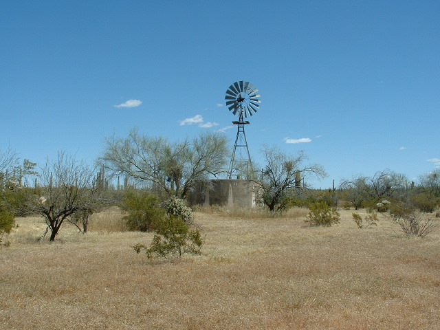
Window Mountain Well
I continued east, away from the mountains, until I arrived at a road junction. Here, I headed north across the Window Valley, steadily losing elevation. En route, I passed the site of the abandoned village of Oit Ihuk. Ihuk is better written as Ihug, which means “the devil’s claw plant”. Oit, better written as Oith, means “field” or “farm”. This road was excellent, shown by the fact that I covered almost 5 miles in only 25 minutes.
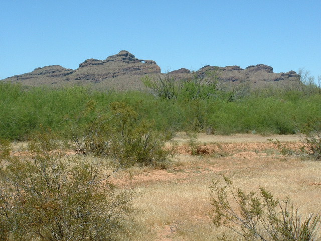
Looking north to Window Mountain, from Oit Ihuk
I then came to a road I had traveled before, and followed it northeast for several miles until I emerged at Indian Highway 34, less than 6 miles east of Ventana Pass. It was nice to finally be on pavement again. What a ride, covering 32 miles of dirt roads, nearly all of it new to me, and another mountain range was finished. It had been a perfect day. Future climbs that year were likely to be in hotter weather.
Please visit our Facebook page at https://www.facebook.com/pages/Desert-Mountaineer/192730747542690