
We awoke to another frosty morning, made stranger by the events of the previous night. As we got ready for the day, we couldn’t stop talking about the mysterious vehicle that Benchmark had heard. He said it sounded as if it had passed by very close to us, that it was moving very quickly, and had faded into the distance. Once we were packed up and had continued to the west, we came upon a north-south road that was a mere 800 feet from where we had slept. That was certainly close enough that we could have heard, from camp, a vehicle traveling on it, so we conceded that one.
Six short miles of driving on pretty decent dirt roads took us deeper into the Sauceda Mountains. This is stunningly beautiful country which was new to all of us, and it was a terrific clear morning to be exploring. Before long, we arrived at our destination, an open area west of a large massif about four miles across. Our goal was to climb Quail Benchmark, a remote and obscure peak which was completely unknown to us.

We prepared our packs and set off, heading east into the rising sun. Things started off well, passing through low open country, until we entered a canyon which became really brushy and filled with boulders. Oh well, we hadn’t had a good bushwhack yet on this trip, so it was high time. Working up a good sweat, we finally broke out of the canyon and carefully manoeuvered our way up a slope choked with cholla cactus. Once past this, a ridge walk brought us to the very flat summit, a thousand vertical feet above the trucks.

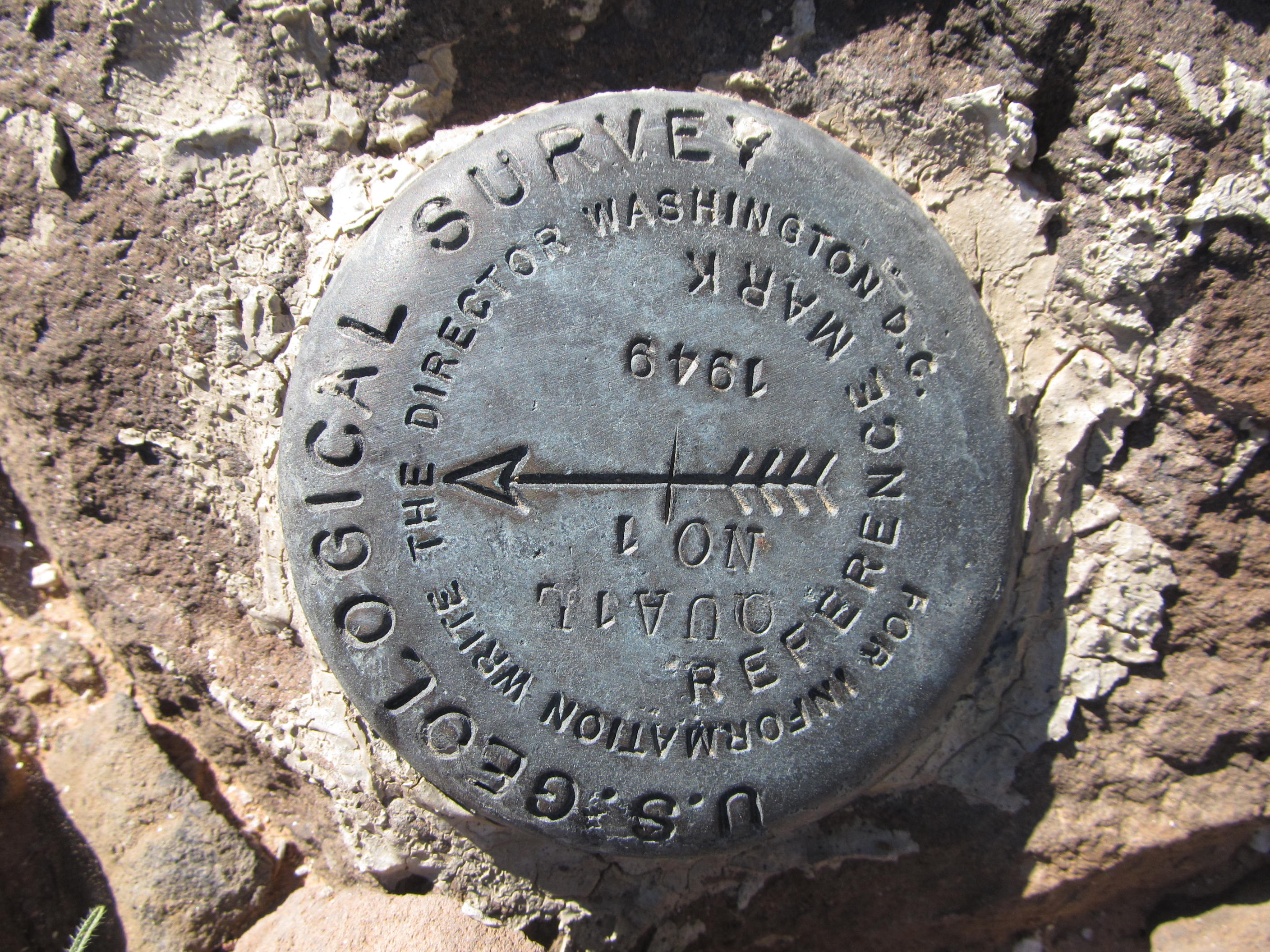
It didn’t take us long to find the benchmark – a dead giveaway was the sticks-and-wire marker left by the surveyors many years earlier, way back in 1949. We didn’t know exactly what we would find up there – hopefully no climbers had been there before us.
However, we soon spotted a cairn, and inside it found a register. That was an immediate give-away that somebody had been there since the surveyors. Opening the jar, we took out a small spiral notebook – it looked familiar, of a style we had seen many times before. What a great surprise! Our friends Barbara Lilley and Gordon MacLeod, world-class peakbaggers from California, had left the register on December 30, 1989. Not a single person had signed in since then. Oh well, we may not have been the first climbers to visit the spot, but we surely were in good company. It occurred to me that I had climbed a peak in the Belmont Mountains with them on December 17 of the same year, less than two weeks before they had bagged the Quail. I had no idea they were planning a trip to this spot, but they are such prolific peakbaggers that it shouldn’t have surprised me at all.
We signed in to the little book and settled down to a leisurely lunch. This place was the epitome of solitude – the only sound to be heard was the gentle sighing of the wind. We really took our time, enjoying the best the desert has to offer. We noticed, to the north of us, a mock village on the desert floor, no doubt used by the military for who-knows-what. I don’t know what time we finally left, but when we finally did, we went down a different way, eventually regaining the canyon and its brush. A moderate thrash took us back to the vehicles.

We convoyed out the way we had come in, filled with questions about the history of the area. How long had it been since ranchers had last tried to eke out a living in this hardscrabble land, before the U.S. Air Force had kicked them out? We passed an old corral, its timbers slowly crumbling in the relentless desert sun – who had run cattle there, where was their home, were they able to make a living?
Cougar Canyon was next on the agenda – we entered and drove south through it, its walls rising 800 feet above the old track we were on. Once beyond the canyon, we emerged into more open ground and came to a road junction. The map showed that the road which headed west went to Pistol Pass. I love these names, they are so much a part of the old west. There must have been an old homestead here at one time, as witnessed by these relics.

We were looking for another peak to climb, and two miles later we found a good one. Peak 2790 filled the bill – it was close to the road and it looked challenging.

We parked by a field of poppies and eyeballed our objective, which seemed to have a double summit. Possible routes seen from the road evaporated as we made our way to the saddle between the two bumps – the whole mountain was overhangs and caves. Standing in the saddle, Rhiker and I were less than enthused about our prospects of reaching the summit. Benchmark was not to be deterred, though – he took off around a corner and out of sight. We waited a while, and then heard a faint shout from him higher up. I’ll be dang-dipped if he hadn’t found a really tricky way up, at least most of the way. He told us to come on up to him, which we did. There was a lot of scrambling, some of it Class 3, which made for some good fun. An airy bit on the summit ridge took us to the top, which showed no sign of a previous visit. It was a good job of route-finding on the part of Benchmark – Rhiker and I might not have made it were it not for his persistence. We left a cairn and summit register to mark our passing, then headed back down. Oh yes, there was one very striking feature nearby, seen to advantage from Peak 2790, and it is seen in the photo below.

It was the magnificent peak called Tom Thumb, definitely not to be confused with the rather (by comparison) lame peak called Tom’s Thumb near Scottsdale, Arizona. There is no comparison between the two. It was just over a kilometer from us. Just looking at it inspires wonder, and, if you are planning to climb it, some definite head-scratching. But the story of Tom Thumb will have to wait for another day. We made it back down to the trucks and moved on. Around three miles farther to the south, we came to Ryan’s Canyon and headed up it for a short distance to the perfect camping spot in a field of orange poppies. Happy hour was in full swing as we watched the hills turn orange in the setting sun.

The following morning, we loaded up the trucks and moved on south. The next three miles took us through some beautiful country, but the last half-mile was on some very rough rocky road, climbing steeply uphill to finally bring us to the gas pipeline once again. We could look back to the west and see Coffeepot Mountain, a major landmark in this area.

The worst of our driving was now over and we could relax. The next six miles were easy ones, bringing us back to the abandoned village of Stoa Pitk. Along the way, we passed these beautiful wild burros.

We left the pipeline road and drove south to Hickiwan, then on pavement all the way back to the town of Why. The guys had decided they had to get back to California and I was sad to see them go. We had had a great week of climbing, one that couldn’t be beat. I had a bit more time, so once they headed west, I drove south on dirt roads and found a good spot to park near Peak 2642. It seemed funny trudging through the desert alone, but I found myself texting the guys as they motored home and I climbed the 800 feet to the summit. I built a cairn and left a register, then descended the way I had come. Once back at the truck, I drove back out to Why, then around to the back of Peak 2357, where I quickly dispatched its 600-foot north side. Locals had signed in to its summit register and so did I.
Back down I went, then drove farther up the highway to the town of Ajo.

I gassed up the old Toyota and then got back on to the gas pipeline road at its western terminus. Driving east out of town, the road was dead flat for a while, but after a few miles I left it for a lesser track which took me deep into the northern heart of the Pozo Redondo Mountains. I got there before sunset and settled in for the night, but skipped happy hour (it just wasn’t the same without the guys). We did text, though, and I learned they made it back home to the coast without incident.
The next morning at daybreak, I set out and headed over to my last summit, the very obscure Peak 2470. It was a short climb and didn’t take long to reach the top. I savored every minute of it, enjoying the solitude that only desert peaks can offer. I left a register, and after a short while I headed down and back to the truck. It was bittersweet, driving back out to the highway and then back home to Tucson. What a great week it had been. We had climbed some great peaks and driven some rough roads in beautiful, remote desert and, to top it all off, nobody had been blown up – how great was that!
Please visit our Facebook page at https://www.facebook.com/pages/Desert-Mountaineer/192730747542690