
The name had always intrigued me. I knew Garibaldi had been a famous Italian guy, but not much else, so I started digging. The big mountain at the head of Howe Sound had been seen in 1792 by the British explorer Captain George Vancouver, the first European to do so. In 1860, while carrying out a survey of Howe Sound on board the Royal Navy survey ship HMS Plumper, Captain George Henry Richards was impressed by a gigantic mountain dominating the view to the northeast. Richards and his officers named the mountain after the Italian military and political leader Giuseppe Garibaldi, who that year had succeeded in unifying Italy by patriating Sicily and Naples.
The first ascent of the peak was carried out in 1907 by a group of Vancouver mountaineers. Their early efforts in this area helped lead to the creation of a large wilderness area called Garibaldi Provincial Park in 1927. So, fast-forward 49 years. I had pondered climbing Mount Garibaldi for a decade, and now the time was right. Unable to find a partner to climb with me, I decided to go it alone.
On July 14, 1976, a Wednesday, I left my in-laws’ home in Vancouver at the wee hour of 4:00 AM. Driving my old beat-up Volkswagon Beetle, I traveled up the coastal highway to the town of Squamish, then drove dirt roads east and up to a spot where I could go no farther. My idea was to go in to climb Mount Garibaldi, then head out a completely different way, ending up many miles farther north than my starting point. I wasn’t sure how I’d get back to my car, but I was young and didn’t care about such details – all that mattered was climbing the peak and having fun.
My car was parked at 3,100′ elevation – I had driven from sea level at Squamish up to here in about 11 miles. I wasn’t too worried about people messing with my car, as it was an ugly piece of crap. In only two years of using it for climbing, I had put 50,000 hard miles on it, and in the process turned it from a nice customized Beetle with a sweet paint job into a Frankencar. I banged it up so badly on rough roads that I carried a large pair of tin snips at all times. Whenever I’d bash the fenders against rocks, I’d snip off another piece of jagged metal, so as not to shred the tires. But I’ve gotta tell you, with that engine over the rear wheels, I could drive places that my friend with his 4×4 was hard-pressed to reach.
I was carrying a full pack, complete with sleeping bag, bivi bag, ice axe and crampons. It took me four hours to travel just over seven miles to reach the old Diamond Head Chalet at around 4,800′ by Elfin Lakes. Imagine my surprise on the way in to see so much snow everywhere – I could tell by the tree wells that there was ten feet of snow by the cabin! I didn’t have skis or snowshoes with me, but fortunately the snow was quite consolidated, so I didn’t sink in too far with mountaineering boots. Here’s a publicity photo of the lakes, taken when there was definitely a lot less snow.

So, here I was – having reached the cabin was a first milestone. Not knowing anything about the place, I shouted out as I approached, and, lo and behold, I heard a reply. The door opened and out came Hans, who identified himself as a warden with Garibaldi Park – he seemed just as surprised to see me. We hit it off immediately, and when I told him that I was going to climb Garibaldi, he asked if he could accompany me. Well, I was delighted to have some company. He told me that he had some time off owed to him by the Man, and there’d be no problem in his coming with me. He threw a few things into a pack and away we went.
Here’s a look to the north – all you can see is Atwell Peak, Garibaldi itself isn’t even visible yet. We had to cross all the snowy bits and cross the ridge on the skyline in the far right center of the photo before we could even see our peak. This photo was taken by my friend Ross Lillie on a different trip two months later in the season but in a later year. When I did my climb, much more snow covered everything.

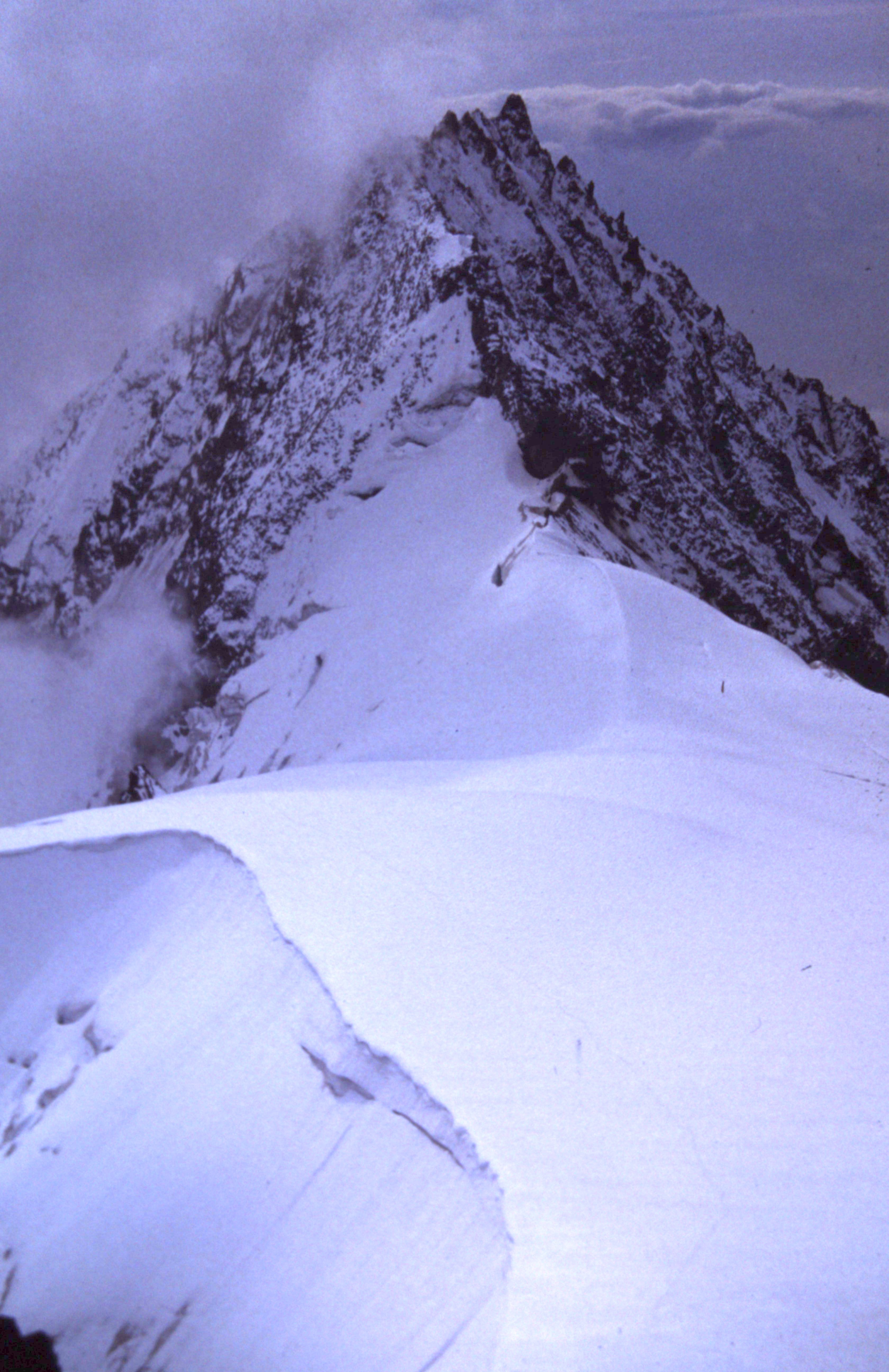
Climbing Mount Garibaldi is fairly difficult – it is steep, and composed mostly of very loose, rotten volcanic rock. That can make things more difficult late in the season. Many of you might think that mid-July is late indeed, but in this part of the world, not so much. The mountain was still deep in snow, and that worked to our advantage. The eastern flank is covered by the Garibaldi Névé, a huge icefield, and that was our goal. We headed north, contouring to the head of Ring Creek, then crossed to the east side and pushed farther north to the Garibaldi Glacier. That led us on to the névé. Here is a view looking west steeply up the glacier. The summit of Garibaldi is the highest-looking lighter rock on the skyline, about 3,000 vertical feet above.

We had no rope, so we needed to be really careful to avoid crevasses – a fall into one could easily have proven fatal. There was nothing to do now but keep climbing – the route lay plainly ahead of us. It took quite a while to climb up to the ridge between the high point and Atwell Peak, an outlier to the south of the main summit, but we weren’t in a hurry. Once we gained the ridge, it didn’t take long to make our way over to the summit glacier between Mount Garibaldi and Dalton Dome, Garibaldi’s west peak. With only 200 feet left to go, a couloir led us to the north-west ridge and the summit. It had taken us seven hours to climb from the cabin to the summit, at 8,787′. Luckily for us, the weather and snow conditions were perfect. Here is another of Ross’s photos, showing the view from Garibaldi south to Atwell Peak. The route comes up steeply from the left to gain the snow ridge.
After a short while, we felt it was time to leave, so we retraced our steps to the Atwell-Garibaldi ridge, then dropped down the east face on the glacier. Making good time, we dropped on to the névé, then crossed the head of the Warren Glacier, passing east of the Sharkfin. Continuing, we came to the 6,200′ pass west of Glacier Pikes, then descended the slopes of the Sentinel Glacier, which were quite steep. Here is a view looking back up the Sentinel Glacier which we had just descended. There is a hut by the rock outcrop. This is a winter photo taken by Ryan Morasiewicz and used with his kind permission, as is the close-up of the hut in the following photo.

Fortunately, the days were very long at this latitude, because it took us until ten o’clock to finally reach a glaciology hut near the foot of the glacier. To say we were exhausted would be an understatement. Here is a view of the little hut taken in winter. It sits on bare rock.

The hut was simple yet comfortable, with a couple of bunks. As we settled in, I chowed down on snacks I had brought. Hans surprised me when he opened a can of corn, then a can of peas, and ate them cold – whatever floats your boat, right?
After a well-earned rest, the next morning we left the hut at 9:00 AM and made our way down to the southernmost end of Garibaldi Lake (I think it was called Sentinel Bay). From there, we thrashed our way along the west shore of the lake. When we reached the lower slopes of Mt. Price, Hans said goodbye – I think he wanted to climb it, but I wasn’t interested. Before long, I saw two girls in a rowboat out on the lake. They were pretty close to the shore, close enough that when I called out to them, they heard me. They rowed over to me, and when I asked them if I could get a ride with them, they said yes. I guess they took pity on me, especially when I told them of my overland adventure. We took turns rowing, and before long, they dropped me off at a trailhead. I was grateful for their help in having avoided a bunch of bushwhacking.
Six miles on the trail brought me to the parking lot, and two more miles of walking down the road (which really sucked because I’d hoped I could catch a ride) finally ended me up at Highway 99. I stuck out my thumb and, before I knew it, a young Japanese tourist picked me up. Here was my plan – I’d gain his sympathy with the story of my adventure, then see if I could convince him to drive me the eight miles of dirt road from the pavement back up to my waiting car. He seemed okay with that. However, the road was rougher than I might have led him to believe. He persisted, none too happily, and drove me all the way to my car, then hightailed it out of there before I had a chance to ask him for any more favors. As predicted, nobody had messed with the old beater, and I threw my pack into it and took off. I made it all the way back home by 10:15 that evening. A whole lot of fun crammed into a 42-hour period. The only reminder of the trip was a world-class sunburn.
Please visit our Facebook page at: https://www.facebook.com/pages/Desert-Mountaineer/192730747542690