
Back in the mid-1970s, I pinned up a topographic map on my bedroom wall – it was the one that covered the town where I lived. It seemed like a good idea at the time. This was back in the day when the only map you could have was a paper copy, there was no such thing as maps on line – hell, there was no line to be on. Since I was always planning which climb to do next, before long a progression developed – the adjacent maps got pinned up on the wall, then the next layer beyond that. Before I knew it, I had bought enough maps from the GSC (Geological Survey of Canada) office in downtown Vancouver to seamlessly paper the entire wall, eight feet high and twelve long.
This was my fantasy wall – I spent more hours staring at it than you’d believe. It was like a retreat, going to my wall. Especially on rainy days, which were numerous in the Fraser Valley of southwestern British Columbia, I’d study those maps, pushing in pins, connecting some of them with bits of embroidery thread of different colors to represent traverses. Oh, the planning that went on! – it was quite unbelievable. Plenty of the climbs actually happened, but as many others were just pie in the sky, never to see the light of day. The planning was almost as much fun as the climbs themselves. With so many irons in the fire, I was always excitedly looking for the next break in the weather, my next chance to head for the hills and make something from my wall a reality.
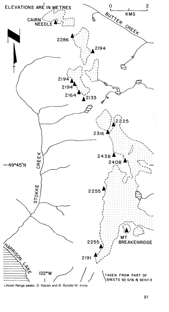
In late 1976, as winter set in and bad weather often left me with nothing to do but, gasp! work, I found myself daydreaming about big things I’d do high up on alpine ridges when the weather finally smartened up. Spring finally came, the snow began to melt up in the high country, and I was more determined than ever to put together a very special climbing project. Something that really caught my eye was an obscure group of mountains called the Lillooet Range. A long chain of peaks starting near the top end of Harrison Lake and running north for many miles, this entire range had seen precious little activity from climbers. It was the perfect candidate. I spent months sticking pins in the maps, different colors representing different elevations. My plan was nothing less than a long traverse through the whole thing, climbing everything in sight and making history.
There was still a missing piece to the puzzle, though – a partner. Anything this insane needed to be shared with another climber. As badly as I wanted to pull this off, almost at all costs, I wasn’t quite ready to do it alone. The summer would see my thirtieth birthday and fifteen years of climbing under my belt, but I just wasn’t ready to do it by myself. As spring progressed, one day I made an important connection. I was hitching a ride to the Skagit River valley and got picked up by Ross and Sonja Lillie and their friend Brian Rundle. Fortuitous, as these folks are still friends 38 years on. We all hit it off immediately and talked excitedly as we rode on.
It turned out that Brian was gainfully unemployed, much like myself, so our schedules meshed perfectly. We immediately started planning future outings, and five days later put words to action with a climb of Mt. Lindeman. During the following eight weeks, we became inseparable climbing partners, with ascents of Mt. Outram, Mt. Shuksan, Mt. Rainier, Mt. Adams and Mt. St. Helens, as well as days of rock climbing at the Squamish Chief and Ruby Creek and even exploration up the then-remote Eagle Creek. By this time, it was obvious that we would head into the Lillooet Range together, and we were about as excited as could be.
On July 20, 1977, Brian and I spent the day at his place in Burnaby making some important preparations for the trip. For weeks, something had become glaringly obvious to us – the scale of this trip was so huge that there was no way we could carry everything on our backs – we’d have to make food drops from an airplane so we could re-supply en route. I pushed hard for the idea of traveling as lightly as possible, so suggested things like oatmeal, trail mix, powdered soups – nothing glamorous, very spartan – so much so that hard candies would turn out to be a luxury item in our provisions. Measuring everything out carefully, we sorted things into daily packages, sealing them carefully. These all went into two large bundles, each weighing 25 pounds, which were double-boxed with padding between the two layers. We waterproofed the boxes with layers of plastic tightly taped around the outside, and finished each one off with long streamers of pink flagging tape, the better to find them later on the glaciers where we’d drop them.
Now all we had to do was fly these boxes out into the middle of nowhere and drop them. Fortunately for us, Brian knew a guy – it’s always good to know a guy – named Terry, who was a bona fide pilot. We met him at a small airport, probably Pitt Meadows, and our plane was waiting. The weather was perfect for flying, not a cloud in the sky. All Terry needed was his pilot’s licence in order to rent it, and Brian and I were happy to pay the princely sum of $26.00 per hour for the aircraft. It seems hard to imagine now that you could rent a Cessna 172 for so little, as it’d be an extra hundred bucks per hour on top of that these days. Although neither Brian nor I had been to that area before, after months of studying the maps we knew exactly how to navigate our way there. The miles passed quickly and we approached our first drop site, a large snowfield well above treeline, surrounded by dramatic rocky peaks. This is what we’d waited for.
Terry didn’t have his mountain flying endorsement, and I think that worried him a bit. He knew we were really counting on him – without these food drops, our little expedition would be a bust. Our plan was to fly as low as possible over the snowfield to make the drop, to minimize the damage to the food boxes. Terry dropped as low as he dared and, bombs away, we pushed the first box out of the airplane window. He banked so we could watch it fall, and it seemed to drop forever, landing intact on the snow-covered glacier. Even this late in the season, the snow cover was deep, so the box cratered into it with no apparent damage. Nevertheless, the drop had been made from much too high an elevation for our liking, so we hoped Terry would swoop in lower for the next one. He turned the plane and flew more miles north, reaching the second spot in a matter of minutes. It was amazing that he could cover that distance so quickly, while it’d take us a week or more on foot. The second box was a bit too big to fit through the window, so we wrestled the door open. That was a struggle, as the wind resistance was very great at over 125 miles per hour, but we did it. One mishap, though – I shoved my big face too close to the opening, and as I peered out to watch the box fall, the wind ripped my eyeglasses off my face and they followed the box down. Bummer.
Our food drops completed, we headed south and back to the airport. Our total rental time was a mere 2.5 hours, which seemed like a bargain to have done something so totally cool. My glasses were quickly replaced, thanks to my small-town optician. Two more days passed, allowing us to make all final preparations for the trip, and we were ready to go. It was time to put boots on the ground.
Day 1: Tuesday, July 26th
Today we had an easy start. A friend gave us a ride to the town of Harrison Hot Springs and dropped us at Riv-Tow’s dock. By 10:00 AM, we and our insanely huge packs were on the water taxi heading north up Harrison Lake. It stopped at several logging camps along the way, dropping off supplies, so that by the time we reached Stokke Creek landing, it was already one in the afternoon. This was the site of an old abandoned logging camp, all of its buildings still standing.
The easy part was over – it’d be nothing but hard work from here on in. Our packs were outrageously heavy. We were carrying glacier travel gear, full rain gear, cooking gear, warm clothing and sleeping bags, plus everything else. I had recently bought an internal frame pack, quite a novelty at that time, and had a first-generation Gore-Tex rain suit (disappointing crap). The only tent we had was a 4-man REI McKinley, which was god-awful heavy. One good thing about climbing in such a wet climate as this was you didn’t have to carry much water, as you were never far from some supply.
Both Brian and I were about five foot ten and 140 pounds, not an ounce of fat on us. Our packs had to be close to 60 pounds, as we were carrying everything we needed to reach our first food drop, probably ten hard days in the future, and all that weight really sucked. Everything always looks so easy on a map, so we headed out of the camp following old roads we had decided on before we ever got there. This worked for a while, and up we climbed, The day was hot – by 4:00 PM, we measured almost 80 degrees F. in the shade, and that was hot for these parts. It was becoming obvious that the route we had picked wasn’t the best – the valley we were in was steep and brushy, and showed no signs of improving. Change of plans. Things were still such that we could change to another route, an old road I had used two years earlier when I had visited this area for another climb, so away we went. This worked out better, so on and up we slogged under our loads, reaching the end of the road at 3,000′. I for one was exhausted. By the time we finished our meager supper, it was 9:00 PM and I was glad to be done for the day. Our first push had gone as well as could be expected – we had covered five miles and gained 3,000 vertical feet with heavy packs. We felt it was a good start, but we wouldn’t have been patting ourselves on the back if we had known what was in store in our near future.
Stay tuned for The Lillooet Range – Part 2.
Please visit our Facebook page at: https://www.facebook.com/pages/Desert-Mountaineer/192730747542690