
Back in the 1970s, when I lived in the Fraser Valley of British Columbia, it was a rite of passage for climbers in that part of Canada to make forays down into the States to climb the big Cascade peaks. The ones in Washington state were: Mt. Baker, Glacier Peak, Mt. Rainier, Mt. St. Helens and Mt. Adams. This story is about Mt. St. Helens.
On July 11, 1977, a Monday, Brian Rundle arrived at my place in Mission. He stayed the night and we had plenty of time to talk about the climb. The next morning, we piled our gear into my Volvo station wagon and headed south. Once in Seattle, we made stops at REI and the MSR store and bought good stuff. Then, we drove down to Olympia, Washington to the home of our friend Jonathan. He worked as an EMT and had arranged some time off. Brian and I were a couple of climbing bums, with no real commitments, so we could goof off and go climbing whenever the mood struck us, which was often. When we arrived at Jonathan’s, we sorted out our gear and visited for a while, then the three of us hopped into the Volvo and headed south. .
It took us a couple of hours to drive the hundred or so miles to the mountain. We talked excitedly as we drove. Even though this was one of the smallest of the Cascade volcanoes, it had to be the most beautiful. A perfect volcanic cone, it had been called “the American Mt. Fuji”.
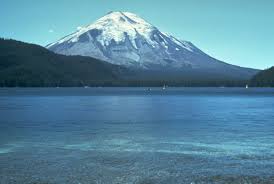
Mt. St. Helens, back in the good old days
It was dark when we arrived at the Timberline parking lot somewhere on the north side of the mountain at around 4,500 feet elevation, and it was raining. We had the place to ourselves, so I slept in my Gore-Tex bivi bag next to the car. By morning, the rain had stopped, thankfully, and the skies had cleared. We had chosen to climb via the Dog’s Head route.
Shouldering our packs at 5:30 AM, we started up a trail. It didn’t take us long to reach the Dog’s Head, a sort of cleaver between the Forsyth and Nelson Glaciers. At the top of the Dog’s Head, we reached the snow-line, and out came the crampons and ice axes, standard fare for climbs like this one. We traversed the upper Nelson Glacier, and then climbed above the Forsyth Glacier. The slope steepened to 45 degrees, then eased up. We crossed over a false summit, and by about 10:45, arrived on the true summit at 9,677 feet. There used to be a lookout on the top, but nothing of it remained. It had taken us 5 1/4 hours to climb the 5,200 feet. The summit was fairly flat and larger than I thought it would be. We hung out a while and enjoyed the unbroken view in every direction – Rainier, Adams, Hood, among others.The weather had cooperated and we had a perfect blue-sky day.
As we descended, we could see that the parking lot had filled up. By the time we arrived at our car, two hours after leaving the summit, we had caused a bit of a sensation. Tourists approached us – they were curious about the crampons, ice axes and other such climbing paraphernalia that we sported. I remember one family asking us if we had gone “all the way to the top?” Upon hearing our “yes”, our stock immediately rose to the level of rock stars.
We drove back to Olympia, arriving by 4:00 PM. It had been a great climb, in the best of company. There was nothing for it but to head out and back to the Great White North. By 9:00 PM, we’d made it back to my place. Brian didn’t stay, instead heading back to his place in Burnaby right away.
A few short years later, I was living in Prince George, a city in northern British Columbia. During the months of April and May of 1980, Mt. St. Helens was a big news item. It was doing a lot of rumbling and smoking, causing quite a fuss, actually. I didn’t own a television at the time, but radio and newspapers kept me informed. One day, May 18th to be exact, I had gone to visit a friend. The minute I walked in his door, he said “Did you hear the news – Mt. St. Helens blew up!” We parked ourselves in front of his TV and saw, over and over, the footage of the explosion. It was hard to believe, but the beautiful mountain I had climbed less than three years earlier had blown off nearly 1,300 feet of its summit. It was now an ugly, smoking shadow of its former self. Gone was that perfect volcanic cone with its beautiful glaciers. Also gone were 57 poor souls who had been too close when the explosion had occurred.
An earthquake at 8:32:17 a.m. PDT (UTC−7) on Sunday, May 18, 1980, caused the entire weakened north face to slide away creating the largest landslide ever recorded. This suddenly exposed the partly molten, gas- and steam-rich rock in the volcano to lower pressure. The rock responded by exploding a hot mix of lava and pulverized older rock toward Spirit Lake so fast that it overtook the avalanching north face.
An eruption column rose 80,000 feet (24 km; 15 mi) into the atmosphere and deposited ash in 11 U.S. states and parts of Canada. At the same time, snow, ice and several entire glaciers on the volcano melted, forming a series of large lahars that reached as far as the Columbia River, nearly 50 miles to the southwest. Less-severe outbursts continued into the next day, only to be followed by other large, but not as destructive, eruptions later in 1980.
More years passed. In July of 1988, I was back in Washington with a friend. We’d been climbing our way north through the Cascades and decided to pay a visit to Mt. St. Helens, or at least what was left of it. There was a visitor center on the southeast side of the mountain, and we stopped in to learn about our options for climbing it. Since the entire north side had blown away, virtually everyone who wanted to summit did it via the south side.
We got an early start. We needed to ascend a mélange of endless, loose cinder slopes interspersed with long snow patches. Two steps up, slide one step back, was the order of the day on the cinders, so we stuck to the snow as much as possible. There may have been a recommended trail, but it wasn’t for us. We followed the Monitor Ridge route, more or less. There were plenty of others making their way up as best they could. The climb was far more demanding and infinitely less enjoyable than what we had done back in 1977.
Eventually, it was done – we stood on the jagged, crumbling rim of the crater at 8,365 feet. Looking down the near-vertical walls inside the crater, we could see the smoking lava dome on its floor. Rocks were falling from the rotten, unstable walls. To the north, the path of destruction was still plain to see, like a nuclear blast had occurred. It was hard to believe that this was the same mountain I had climbed before. As the years go by, I’m part of an ever-shrinking number who’ve stood on the original, pristine, pre-eruption summit. I’m glad I had that opportunity.
Please visit our Facebook page at: https://www.facebook.com/pages/Desert-Mountaineer/192730747542690