
Rhodes Peak
Back in 2007, Andy Martin talked me into an attempt on Rhodes Peak in the Galiuro Mountains. He and Bob Packard were going to give it a try and I agreed to go with them. It was April 1st when Andy and I drove from Tucson in his vehicle. At 5:15 AM, we met up with Bob along Highway 77, then drove south on River Road until we reached Rhodes Ranch Road. I joined Bob in his vehicle and we convoyed 2.5 miles up the ranch road where Andy parked. The 3 of us then rode in Bob’s truck until we had gone 6 miles up the ranch road, where we parked at a locked gate. This was 6/10 of a mile before the ranch. We then walked east past ranch buildings and up ranch roads towards the escarpment on the west side of the Galiuros. We finally reached the base of a canyon, un-named on the map, the one between Schoenholzer Canyon to the north and Buck Canyon to the south. It was around 5,000 feet elevation where we entered the canyon. I remember it as being brushy and wooded, and rocky in places. One trip report describes it like this: at that point the fight, scramble, and climb begins immediately and doesn’t let up. After much difficulty and mostly class 3 and some class 4 climbing ……. Andy recalls that we sidehilled along the north side of the canyon for some time. We finally reached the ridge crest at around 6,900 feet and had an easy walk south on an old trail to reach the summit of Rhodes Peak at 7,123 feet. It was a comfortable 70 degrees on top. We didn’t stick around long and soon started back down. Hours passed, and it was late in the day by the time we exited the canyon. By the time we made it back to Bob’s vehicle, we had been on foot for 11 3/4 hours and had covered 9 miles with 3,800 feet of elevation gain. I managed a phone call to my wife, apologizing for how long the climb was taking. She had made a nice dinner but I returned home so late that we couldn’t enjoy it. That day, climbing dropped another notch in her estimation!
Whistle Stop
Have you ever heard of a whistle stop? I don’t know if they still do it any more, but back in the 1960s it was still in practice. We took a train north to near our mountain objective but wanted to get off at a spot where the train normally did not stop. They did in fact stop and let us off in a good spot for the start of our climb, and also gave us instructions on how to get back on the train for our return journey home. Here’s how we did it. Once back down off of the mountain, we reached the railroad tracks and walked along them.
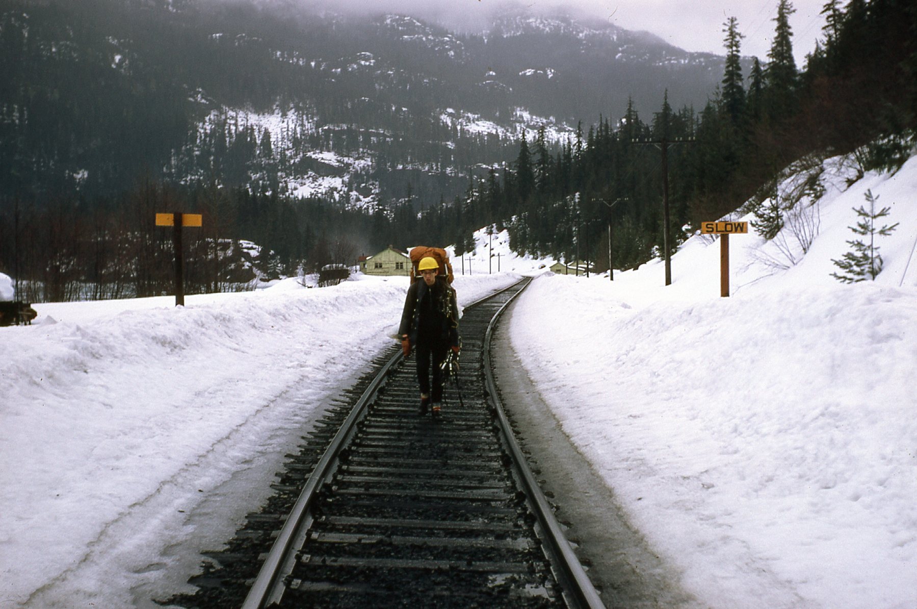
The trudge along the tracks, snowshoes in hand.
We reached a shed designated as a whistle stop and rested there until we heard the train approaching. All we had to do was put a flag which was stored inside the shed into a holder (seen as a dark rod on the area just below the roof on the right side). The conductor slowed the train to a stop so we could climb aboard. It was a passenger train with just a few cars, so it didn’t require much distance to stop. Here is where we waited. The entire process was about as easy as could be.
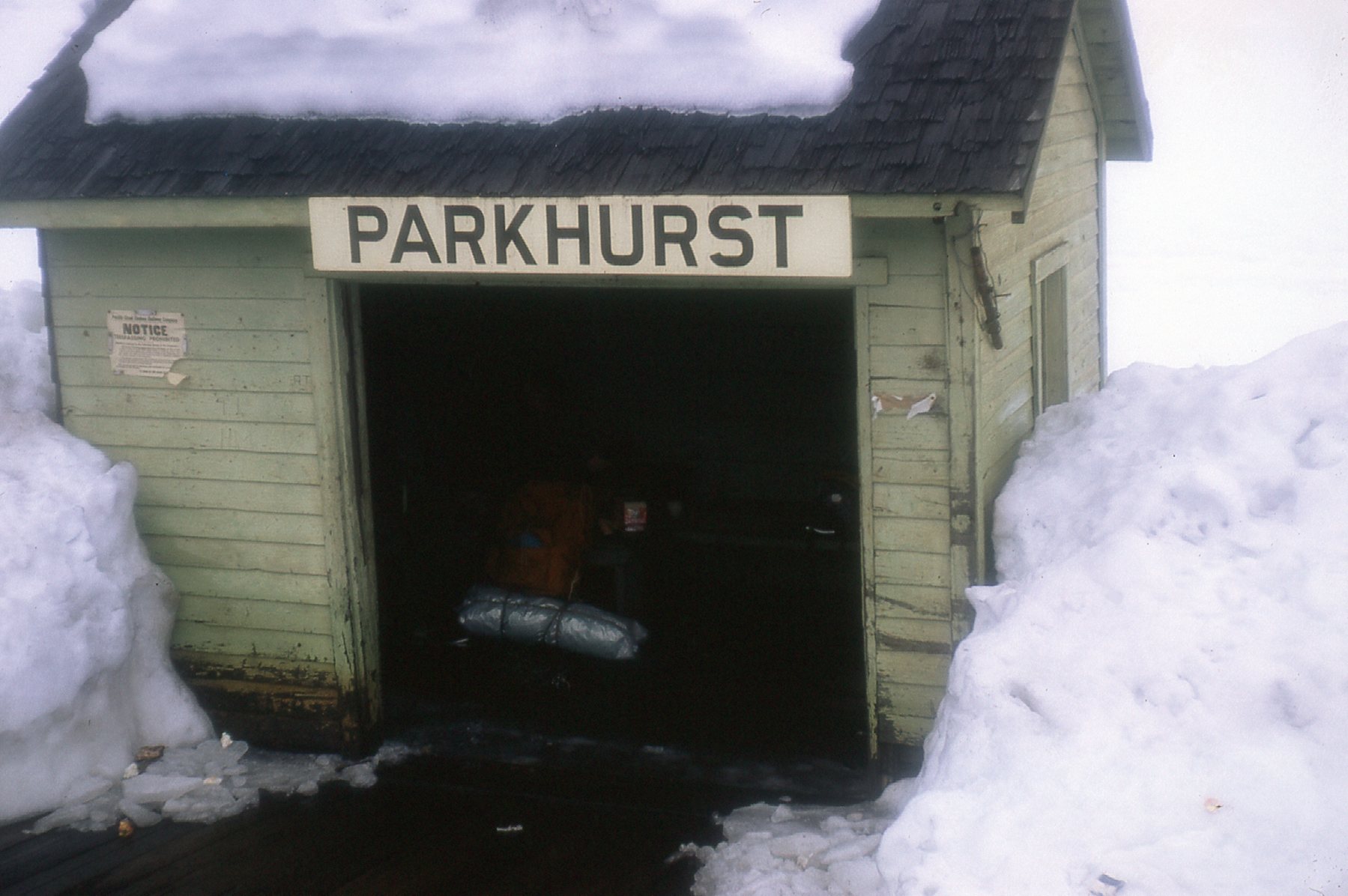
The whistle stop.
Wind Meter
Way back in the 1970s, as part of the climbing paraphernalia that I bought, was a small, lightweight device for measuring wind velocity. It was really handy if you’re into that sort of thing. All you had to do was to face it into the wind to get a reading. The thing was pretty indestructible and that’s why it has lasted these 50-odd years. It had 2 scales, one for measuring lower-velocity winds and one for stronger winds. How it worked was simplicity itself. Look at this picture of it. I’ll describe the various parts. At the top is the clear plastic case to hold it all. On the label that says “wind meter”, there are 4 boxes. The one that is checked is the model you have. You could get it 4 different ways, and that meant that the scale inside the wind meter itself would vary depending on the model you had. The choices were: MPH; KPH; KNOTS; MPS. Mine was the MPH, or miles per hour. The next piece down is a small white envelope with good instructions to help keep your device in good working order. Below that is the red and white plastic wind meter. Finally, below that are some cleaners to keep it operating at peak accuracy.
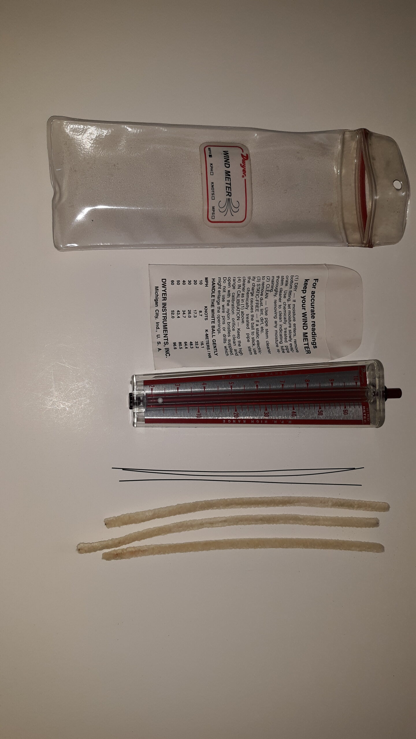
The full wind meter kit.
Here’s a close-up photo of the wind meter.
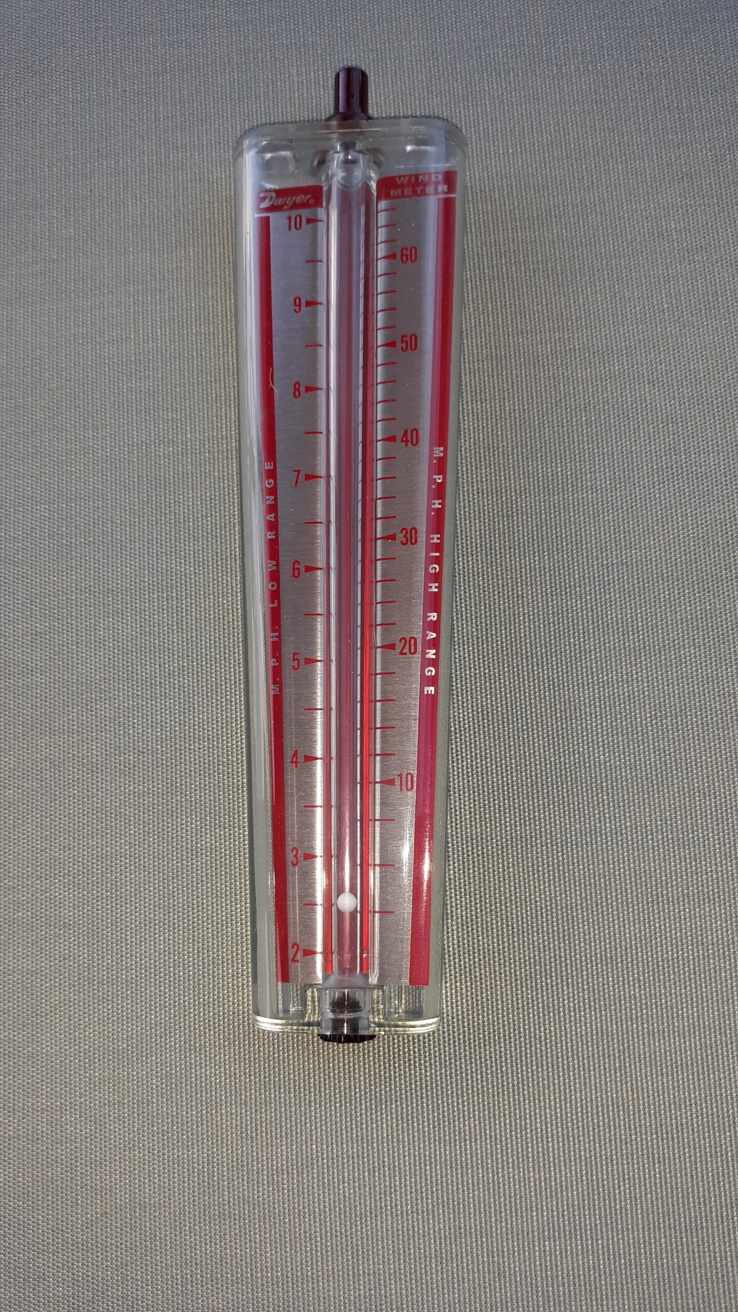
The wind meter
The tiny white ball would rise inside the tube as wind strength increased. On the back side of the device were printed these instructions:
TO USE: Face the wind. Hold meter in front of you in vertical position and with scale side toward you. Do not block bottom holes. Height of ball indicates wind velocity. For high scale, cover hole at extreme top with finger.
You can’t see it in the photo, but on top of the dark projection at the top of the meter is a hole. You cover it with your finger and then velocity can be read on the right-hand scale. This little device works really well. I took it on many major climbs. The entire kit only weighs 2.3 ounces.
Crampon Trouble
In March of 1976, I climbed to the top of Popocatéptl, a big volcano in Mexico. As I sat there on the summit at 17,802 feet, I decided to tighten my crampons for the descent. I loosened them, took them off for a moment to check that they were still ship-shape, then went to put them back on. I had been feeling the effects of the altitude during the climb – a headache and feeling somewhat spaced out, and now, on the summit, found that I was operating at less than peak efficiency (no pun intended). Tightening the crampon straps was a simple procedure under normal circumstances, the work of 5 minutes. However, it was not a normal day – I was shocked to see that by the time I finished, a full 45 minutes had passed. Once done, I descended the 3,000 feet to the climber’s hut without incident.
Alpine Climbing
Recently I read a book by John Barry entitled “Alpine Climbing”. Another name for this type of climbing is alpinism. I liked how he defined the sport. “It is a game played on rock, sometimes only on rock; a game played on ice, sometimes exclusively on ice; and it is a game played on both, alternately as well as at once – yes, even with one foot on each of those things at the same time.” He goes on to say “It is a game played on mountains of snow or ice or rock, more usually on glaciated ground, more often at altitudes of 10-20,000 feet, as a rule starting somewhere near the mountain’s natural bottom and going on to a natural top.” He also says “Good alpinists are many things. They’ll be fit and hardy, weatherwise (and nearly weatherproof), good judges of conditions, planners as well as improvisors; route finders, avoiders of unnecessary toil and unwanted crevasses, and above all, good all-round climbers, equally at home on rock or ice or mixed.”
Refugium
Have you ever heard of a refugium? I hadn’t until a few years ago when I found myself in one. I googled the word and found 3 definitions for it:
- In fishkeeping, an appendage to a marine, brackish, or freshwater fish tank that shares the same water supply.
- The Refugium Range is a mountain range on Vancouver Island, British Columbia, Canada.
- A location of an isolated or relict population of a once widespread animal or plant species.
In my case, I was in the Mt. Graham Red Squirrel Refugium. This was an area of 1,700 acres near the highest parts of the Pinaleño Mountains in southeastern Arizona. These tiny squirrels weigh only 8 ounces and are critically endangered – perhaps only 100 or so still survive in the wild. Here is a picture of one of the little critters.

San Rafael Glacier
I wrote a piece on this website about how South America is in some ways colder than North America. You can read it here – just Part 14 is all you need:
Now that you’ve read how South America is colder, you’ll appreciate even more the following fact. The San Rafael Glacier is the closest glacier to the equator on the entire planet which comes right down to the ocean. It reaches the ocean at tidewater at south latitude 46.7 degrees in Chile. Why is that special? Well, if you were to go to northern latitudes and get yourself to the same 46.7 degrees, it would place you just north of the Oregon border, near Chehalis, Washington. Can you imagine a glacier coming down and emptying right into the ocean on the same level as Chehalis? Nope, no way, no how. In fact, if you want to head north from there and find the first glacier in North America that reaches the ocean, you’d have to travel all the way to 58.3 degrees latitude. That’s almost all the way to the Yukon!! That’s a difference of 11.6 degrees of latitude, or 800 miles as the crow flies. You can read the above-mentioned story for an explanation of how this is possible.
Cheap Cones
In the mid-1960s when I was a student at the University of British Columbia, at one of the student dorms called Fort Camp they had a store that sold snacks and especially ice cream cones. They always had several different flavors of ice cream on hand (it wasn’t soft-serve, but rather the hard kind you had to scoop). It only cost 10 cents for a cone, and the great thing about it was that you could have as many scoops as you wanted. The dedicated workers would pile on as many scoops as you wanted, all for the total cost of one thin dime. Sometimes we would walk out of there with 4, 5 or even 6 scoops piled high on the cone – it was all you could do to eat it before it tipped over or fell apart.
Difficult Mail Service
One summer I worked at a remote mining exploration camp in the Yukon. Every 10 days, a helicopter arrived with food, supplies and especially mail. There were no roads in to the place so the chopper was our lifeline to the outside world. When the mail arrived, we would read it hungrily. And of course we could send our outgoing mail with the chopper. The problem was that the chopper didn’t wait around for us to write responses to our mail, no matter how important they were. The pilot was often gone within 5 or 10 minutes, and most of that time was spent unloading the chopper. So you might get a letter that required a response, but couldn’t send your response out until 10 days later when the chopper next arrived. This could be very frustrating, and as you can imagine, some things were very delayed or even overdue by the time our response was received in the outside world. It’s easy to imagine how, with modern technology, an internet connection could have changed all of that.
Serene Birthday
In the summer of 1967, I celebrated my birthday in a special way. All summer long, I had been hoping for an excuse to visit an especially remote spot. I talked my boss into having the chopper drop me off quite a few miles up the Chutine River. It was to be an easy day, doing a bit of prospecting, but mostly just enjoying the solitude.
What a place! Although the river was only about 50 miles in total length, its source was deep in the huge icefields which lay across the British Columbia – Alaska boundary. Those icefields contain some of North America’s most spectacular and challenging peaks. Mt Ratz’s elevation is 10,137′, and it has a prominence of almost 8,000′. Chutine Peak, although lower, still has almost 5,800 feet of prominence. And Devil’s Paw – although it is only 8,584′ in height, it too is classified as an ultra, with 5,686′ of prominence. Kate’s Needle tops out at 10,016 feet. And, not to be ignored, is Devil’s Thumb – its northwest face, 6,700′ in height, is considered the greatest in North America, so difficult it has never been climbed.
So here I was, flying high over the Chutine River and completely mesmerized by the view as we headed west towards the Boundary Icefield. We didn’t go that far, but the pilot did finally set me down in an alpine meadow. I spent about 8 hours in blissful solitude, soaking up the views and not looking at a single piece of rock. By the time the chopper returned to pick me up, I realized I’d had an extraordinary day, one I still cherish almost sixty years on.