
Every climber has rituals, things that they do on a regular basis – I know I have mine, and I thought I’d share some of them with you here.
One of my favorite rituals is the climbing register. You’ve heard me mention these in a great many of my stories. I’m a believer that a summit should somehow be able to share its history with anyone who visits. Yes, there are websites where climbers can log their ascents, but not everyone bothers to do that. Besides, some of those who reach a summit don’t know about these sites. Some reach a summit never knowing in advance they would end up there. But it’s hard to go wrong with a register sitting on the summit.
Here in the desert, what works best is a glass jar with a tight-fitting lid, something air-tight. Inside it would sit an ordinary lead pencil and a piece of paper. The climber opens the jar and writes their information on the paper, then seals it back up. Pencil, not ink, is what does the trick. Ink fades quickly in most climates, especially here in the desert. Back in 1976, I climbed a peak in British Columbia in the winter. The summit was deep in snow, but a small rocky area was windswept and bare. There, I spotted an old tobacco can, open to the elements. Sticking half out of it was a piece of paper, and written on it was the name of a man and the name he chose to give the peak. Amazingly, he had left it there in the early 1940s. It had sat there, relatively unprotected, since the days of World War II, and yet the pencil writing on that scrap of paper was still quite legible! Any ink message would have long since faded.
Ordinary white copier paper works well. I leave a sheet of paper, folded or rolled, to fit inside the jar. Some climbers leave a small, spiral note-pad. Many of the peaks I climb haven’t seen a visitor before me, and it may be years, decades or forever before someone else visits the summit again, so a single piece of 8.5 x 11 inch paper could suffice. A plastic jar or bottle will quickly degrade in the heat and cold. The pencil need only be something small, a few inches is fine. I once knew a famous climber who felt that if you didn’t bring your own pencil to sign in, then you didn’t deserve to. I always leave registers with a pencil, as does everyone else I know.
Richard Carey of San Diego has elevated the register to high art. First, he finds two cans of a size that can nest one inside the other. He sprays them with a rugged exterior paint, and chooses a glass jar small enough to fit inside the inner can. Their bright red color is his trademark, and his registers can sit on a mountaintop for decades and look like he just left them the day before. Here’s one I found in the Tank Mountains – I’ve opened it up so you can see that, aside from some dust and bugs, it’s still 100% intact 15 years after he placed it. The paper inside was just as fresh as the day he left it.
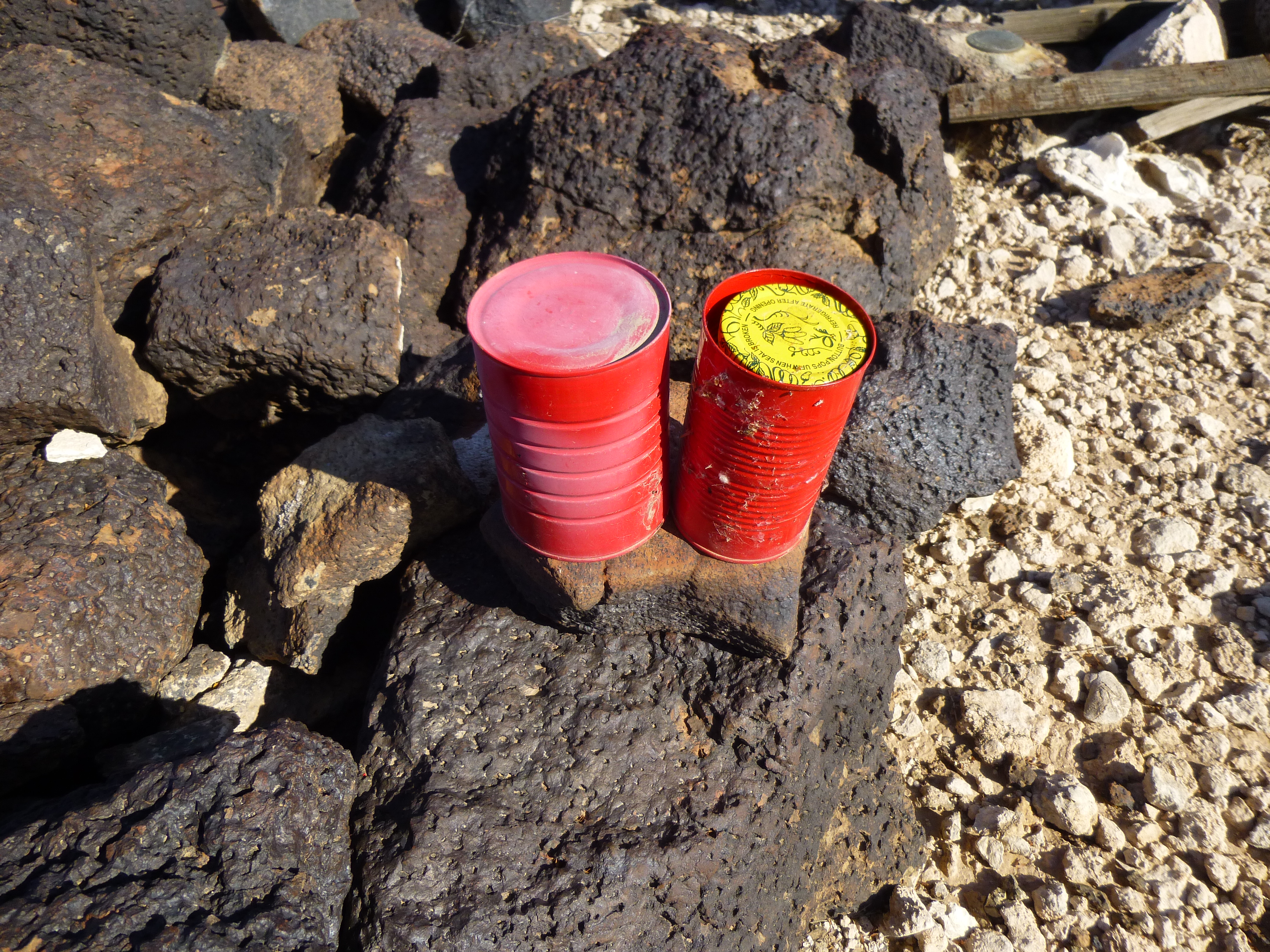
Rich’s register
Another important ritual is the summit cairn. You don’t want to leave the glass jar lying out in the open, exposed to the elements. It’s best to build a mound of rocks around it, done carefully so you don’t crush the jar, enclosing it so the cairn leaves a space inside in which no rock is touching the jar. Maybe resting gently on the lid is okay, but gently being the operative word. A summit cairn is something with which many visitors to mountaintops are familiar – to non-climbers, probably more so than a register. Some cairns are huge, like this one left by an early survey party. It stands 6 feet tall. Brian Rundle and I once built one on a remote summit in Canada that was even taller.
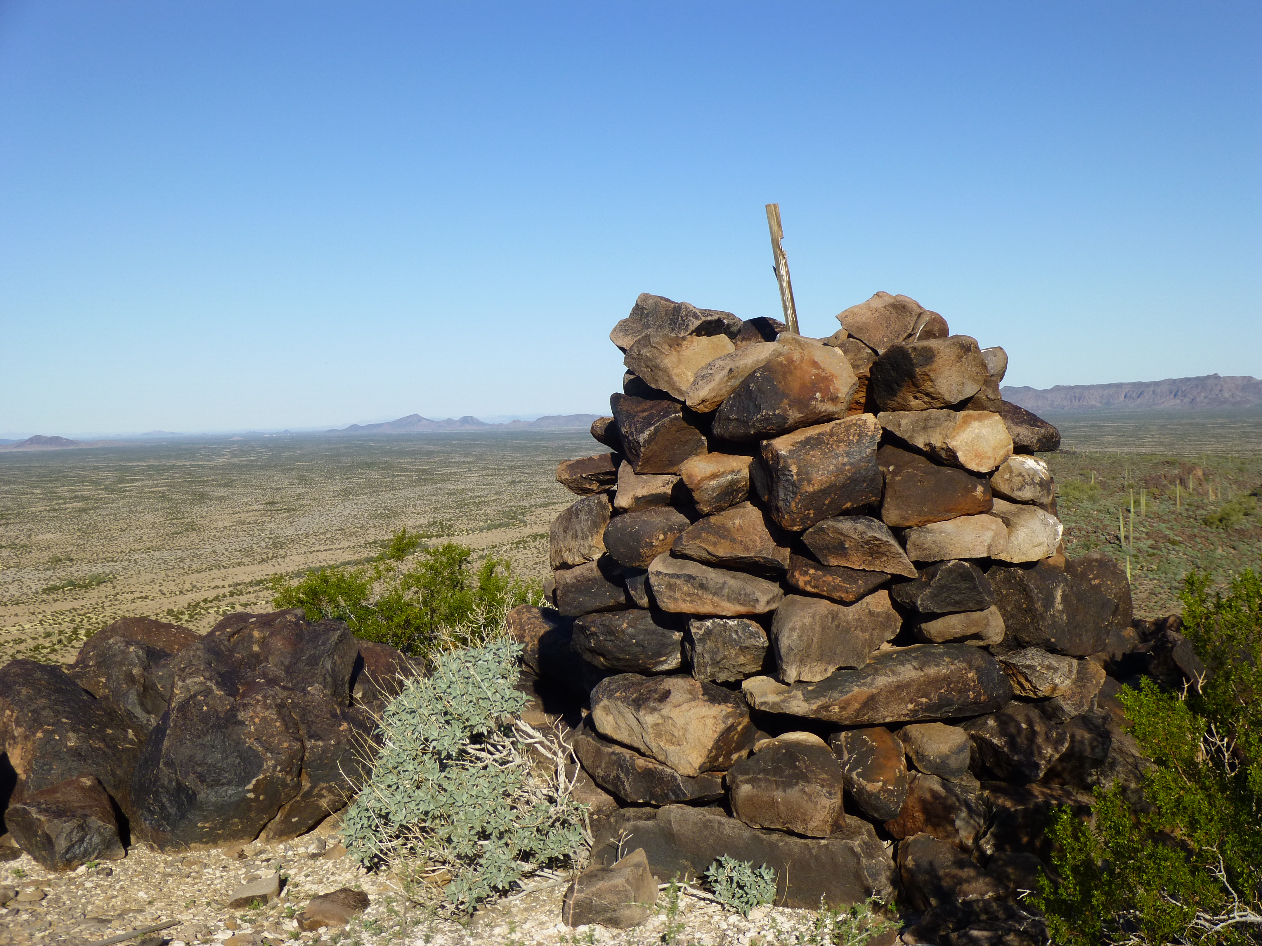
One big cairn
For climbers, the cairn not only protects the register, but also serves to draw your attention to where the register is located. Climbers will always, upon arriving at the summit of a mountain, look for the register. That way, they can sign in and also see who else has been there. On some peaks, the register may be well-hidden. That is more likely where it may be removed or destroyed by others who don’t want it to be there in the first place. I know of instances where the military has destroyed a register; ditto for tribal members on Indian reservations, or property owners on private land. Sometimes a register will be removed by government employees on Federal lands (like a national park or monument) or State lands. That’s why peakbaggers will search carefully for a register on a summit – it may not be really obvious. Some of those I’ve left have been well-hidden – I know peakbaggers will likely look for it and find it, where more casual visitors won’t. A significant problem on peaks near the border with Mexico is Bad Guys removing or destroying registers. In recent years, I’ve seen this dozens of times, and it’s always disheartening. A summit register is a piece of history and should be respected. If I visit a “border” peak and see that a register has been removed, I usually won’t leave another in its place, as I know it too will soon be destroyed.
On a stealth climb, it may be advisable to sign in more anonymously – perhaps just put the date, but not your name or the city you’re from. Some climbers will use a pseudonym in such cases, one known to the climbing community but not to the general public. It’s not just climbers who will sign in to a register. Some of the entries I’ve seen have included: hunters, government workers, geologists, prospectors, tribal members, property owners, undocumented border-crossers and Border Patrol. I have also found terracache information on summits, but those folks seem to prefer leaving their own registers.
A register is a place to also leave a comment, and many of those who sign in do just that. Anything goes, whether it be positive, negative, spiritual or even R-rated. The entry may include information about the route taken to get to the summit, or the weather conditions that day, or other things observed along the way. I’ve seen nasty comments written by property owners, warnings to not cross their land under threat of prosecution.
Some old registers have deteriorated – water may have entered and left the paper a soggy mess, or mold may have blackened it. It’s not uncommon for a climber to leave a new, better register to replace the old one. Sometimes the old contents will be left in the new jar along with the new paper. Often, any legible information from the old paper will be written on the new, so that the historical record is maintained and credit is given where credit is due.
Another personal ritual which is important to me is parking – how and where to park. My truck has been broken into twice now by border-crossers out in remote areas. It’s just not worth the hassle of replacing broken windows and making repairs, so these days I leave it unlocked. I make sure there’s nothing of value in it when I’m gone, nothing I would miss if it were stolen. I disable the truck so it cannot be driven, and I leave a club on the steering wheel. I also leave a gallon of water outside, plainly visible, with a note in Spanish telling any passers-by to help themselves to the water and please leave my truck alone. If I’m in a spot where a permit is required, I make sure the permit is clearly visible to law enforcement or others who might want to see it.
I may park in an open spot, perhaps on a rise, if I want the vehicle to be visible from a distance, either by me or others. On the other hand, I may hide the vehicle well, down in a wash or in a pocket of vegetation – it just depends on the circumstances. Sometimes you need to park on the side of a highway or freeway to approach a peak, knowing full well that you’d better get your climb done quickly so you don’t get a ticket for being there too long. Even parking out in remote places can be problematic. I have friends who parked and set out on foot to do a climb, only to return and find they’ve been cited for parking illegally. This has happened on military or Indian reservations, in wilderness areas and also in national parks and monuments.
Let’s talk about maps. I’ve been climbing for 56 years as of this writing, and that’s plenty enough time to have developed some strong feelings about maps. Way back in the day, we had to buy paper copies of maps, and they were expensive. Nowadays, there are any number of websites where you can peruse maps of just about any location and print as many copies as you want for free. There are also excellent apps available these days, ones which can be downloaded (also free) to your cell phone and used in the field. I’m not the most tech-savvy guy, but even I have two of these apps on my phone – Earthmate and BackCountry Navigator. They allow you to track your position in real-time using satellite technology. Whether you’re driving or on foot, they will show you your position on a topographic map on your phone screen as you move along. Nevertheless, I do carry and always will carry paper maps with me as a back-up. Besides, I write notes on the maps as I travel. Another thing I’ve learned is that you can’t ever have too many maps, whether paper ones or the coverage on your devices. Any number of things can change in the field, forcing you into an area different than the one in which you started. Once back home, I keep all field copies of maps for my records, complete with even the smallest details of the climb. And yes, I have thousands of them, but they are a precious legacy of my climbs.
As great as those apps are, and as much as I enjoy using them, my feeling is this – things that depend on batteries have inherent problems. The batteries can die and you may not have spares; you could drop the device and break it; you could lose it; the device could simply stop working; problems could develop where you cannot navigate the software properly and through user error the device is no longer usable. What I’m trying to say is that a paper map and compass should always be carried, and your orienteering skills should be kept up-to-date.
That being said, I have found myself in situations where, due to weather conditions or unusual topography or the dark of night, even a map and compass aren’t of much help. In such cases, a GPS or one of those apps I described earlier can save your ass, especially if you had it record the track you followed on the way in. I will readily admit that I carry paper maps, as well as my GPS and also my phone with the apps. I carry my phone anyway in case of emergency, so the apps are already in there. Layers of redundancy. The desert is a harsh mistress – break a few of her rules and she’ll kill you, no question about it, so I try to be over-prepared.
Another thing I carry is one of those emergency rescue devices. It connects to the Iridium system of satellites, and if worse comes to worst, all I need do is press the red SOS button on it to call for help. It allows me to send and receive text messages from anywhere on the planet, so I can communicate with rescuers. I’ve never had to press that button, thankfully, but it’s there if I need it. Another great thing it lets me do is to send messages as I travel, to a pre-arranged list of friends or family. For example, I can send one of a set of generic messages (eg – “I am fine and on track”) as often as I wish. I always send one from where I park, from any summit and when I am back at the truck. However, I could send them as often as I wished, a hundred a day if it so pleased me. Much more important than just the words, though, is the fact that the message includes a link to a topographic map and even a satellite view, both of which show my exact location with a precise latitude and longitude. Those receiving my messages could also “ping” me at any time they pleased to see exactly where I am. I also send one from my campsite each night. In addition to the pre-set messages, I can also send any custom message I wish to anyone in the world, a text or an email and as easily receive their reply.
One time a few years ago on a remote peak in Mexico, I lost my GPS. I had used it to mark the spot where I had parked my truck, which was visible from the mountaintop miles away, but once I descended to the flatlands I could no longer see it. I made a beeline for where I thought it was parked, but the closer I got the more unsure I became of its whereabouts. The Sonoran Desert is the most vegetated of all the world’s deserts. My botanist friend Jim Malusa at the University of Arizona tells me that it contains at least 2,500 different species of plants (and that’s just in the dry areas, not counting the more lush mountaintops). When my friend and I reached the area where we thought we’d find the truck, it wasn’t there! We had a pair of two-way radios, and walked a grid pattern for an hour through the thick vegetation before one of us stumbled across the truck. The GPS, had I not lost it, would have directed us right to the truck. I guess what I’m saying is that those devices do have their place and can play an important role.
That’s enough for now, but I may write more about climbing rituals and customs in the future. Thanks for listening.