
There’s a beautiful mountain range in southern Arizona that is easy to reach, only a couple of hours from either Tucson or Phoenix. It’s in the south-central part of the state, and it starts at the Mexican border and runs north for 24 air miles. The fact that it abuts Mexico adds a bit of spice to the range, as it is a conduit for the Mexican cartels to bring both drugs and indocumentados into the country. I’m talking about the Ajo Range, which is not only a real stunner to look at but also a delight to climb in. I’ve been going there since1986, and it never gets old.
I’ve been wondering about the best way to take you on a journey through the range to show you its beauty. At first, I thought I’d discuss them in the order I climbed them, but that would have us jumping back and forth all over the place and might get confusing. Then I thought about starting at one end and working my way down to the other end, and that made a lot of sense. However, I’d need to keep things organized, as there are, let’s say, 3 types of peaks to discuss. About half of the peaks lie to the west and are in Organ Pipe Cactus National Monument. The other half, to the east, lie in the Tohono O’odham Indian Reservation. One more thing to note before we begin is that 10 peaks in the total of 48 are border peaks – that is to say, they sit squarely on the sinuous boundary, or border, between the two jurisdictions. So here’s how I think I will conduct this tour for us: I will start on the Organ Pipe side, and work south, including the border peaks in this group. Once I’ve reached all the way south to Mexico, I will then jump back north and start in the Tohono O’dham side, working my way south in their land and end up at the Mexican border again.
I’ll comment briefly on each of the peaks, but will also include a link to each one. If you click on the link, it will open up a new window with a small map. You can click on the map to get a wider view. Also, there should be a photo of each peak so you can see what each one looks like. Over to the left of the small map you may see a trip report, which you can click for a description of how the peak was climbed. Ready? Let’s begin.
At the far northern end of the range, less than 2 miles into Organ Pipe, sits a little mountain known as Peak 2602. If you click on the link, you will see two photos – the one on the right is closer to the summit, and the peak is a solid Class 4 (best to rope up if you have a choice). This is a fun, intricate climb.
Nearby to the south of 2602 is Peak 2725. This little beauty has only been climbed by one party – it’s tricky, the opening move is an overhang, Class 5. That overhang has stopped at least one party in the past before it was finally climbed. These first two peaks I have nicknamed “Montezuma’s Feet”, as they sit just a mile to the north of the much bigger Montezumas Head. (I know, where’s the apostrophe?, but that’s how the official name is on the map).
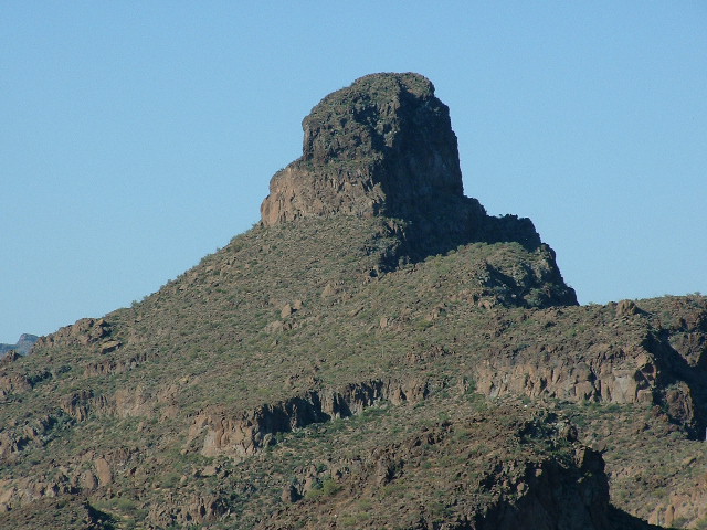
Montezumas Head is the real elephant in the room. It dominates everything in the northern part of Organ Pipe and can be clearly seen from miles away in every direction. It is a very technical roped climb, and it scared me more than any peak I’ve ever climbed in my entire life. There was just something about it that gave me the creeps – maybe it was the breathtaking exposure. The O’odham people have their own name for this mountain – I’itoi Mo’o. It means “I’itoi’s Head”. I’itoi is their creation God, so this is a revered peak for those people. Climber Andy Bates led all 3 of these first peaks when I climbed them.
Nearby to the east can be found the first and northernmost of those ten border peaks, namely Peak 3650. This beauty rises 1,400 feet from the desert floor. I should also mention that when the boundary between Organ Pipe and the reservation was first determined, surveyors left a series of 21 metal posts to delineate that border. Post #1 sits along the ridge about 2,000 feet south of 3650’s summit. These are shown with the letters MP.
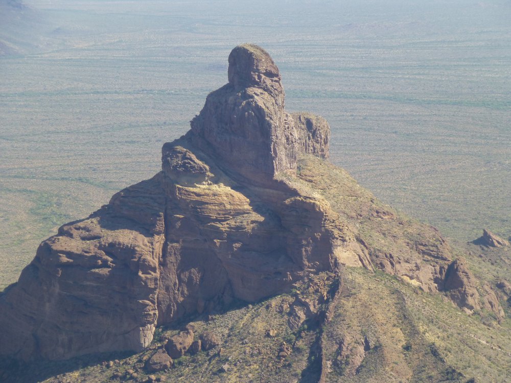
Next, we come to the second of the border peaks. This beauty can be seen from miles away due to its unique shape. If you follow the winding border south from MP1, you cross over Point 3527 and Point 3630 and then arrive at MP2 after 1.4 miles. MP2 sits at 3,800 feet, and from there the ridge rears up – a walk of 1,100 feet along the ridge takes us to the summit of our second border peak, the stunner known as Peak 4088. Here is a good look at the peak. Five of us went in to climb this one, and three of us wanted the security of a rope. The final bit of the summit block has outrageous exposure. This peak towers over even Montezumas Head, less than 2 miles away to the northwest.
Peak 4088, as seen from the north near Peak 3650
Staying on the Organ Pipe side, the next peaks we come to sit up high, at the head of the North Fork of Alamo Canyon. They are the highest ones yet. Peak 4220 sits aloof, a good 600 vertical feet higher than Montezumas Head which is a mile and a half due north.
Looking north to Montezumas Head
When you climb Peak 4220, you feel like you’re really out there, far from the works of man. A nearby neighbor of 4220 is Peak 4180, only a mile away to the southwest. This is quite an exhilarating climb, involving slabs and an exposed narrow ridge at the finish. It was one of the most memorable in the range, at least from my perspective.
Another summit that can be reached via a branch of the North Fork is Peak 3460. It can also be approached by the steeper western slope. This peak is quite unique, which can be seen when you look at the photo. The actual highest point is atop the arch. I was there in 2017, but the arch seemed so delicately poised that I wonder if it is still standing. In this close-up, you can see the large boulder hanging in the air – it is huge, and must weigh a few tons.
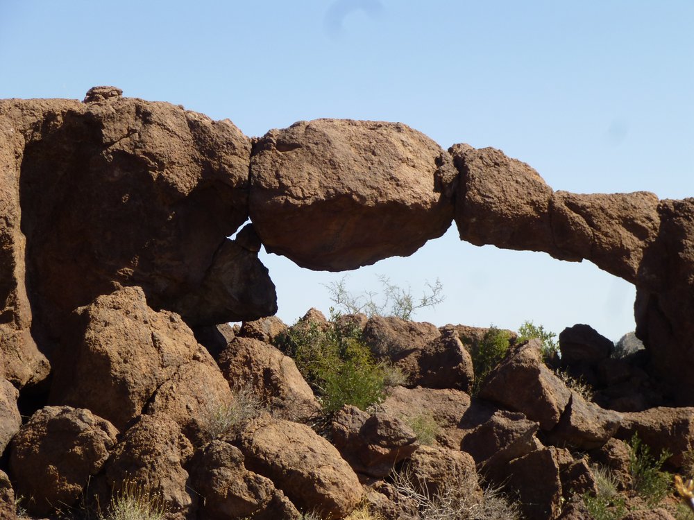
The delicate arch
Meanwhile, back on the border ridge, we can have another look at things. We left off at Peak 4088, so let’s continue south along the ridge. After another mile, we reach MP3. Continuing south, we reach MP4 after 1.2 miles more, then we reach MP5 in another 1.2 miles. If we continue beyond MP5 for another 0.9 mile, we find ourselves atop Peak 3820. This one sits way out there all by itself – south of one of the branches of the North Fork and north of the Middle Fork of Alamo Canyon.
Let’s go back out to the Organ Pipe side. Just south of the rustic campground at the mouth of Alamo Canyon can be seen Peak 2900. A camper I met there one day described this peak as looking “like a bad molar”. This is a fun little climb, with an exposed finish at a stiff Class 3.
Okay, back to the border peaks for a minute. Where we left off earlier was at Peak 3820. If we head south along the border, we come to MP6 about 4/10ths of a mile later. Another 1.3 miles along the high ridge brings us to MP7, and a few hundred yards beyond that we arrive at Peak 3940. One time I went up the South Fork of Alamo Canyon to try to climb that peak. All I have to say about that is – Don’t Go There!! It was a green vegetated hell, one of the worst bushwhacks ever. I retreated, soundly defeated. A month and a half later, I went back with Jake Cramer and we went up the Middle Fork, which proved a better route. That got us to the summit of Peak 3940. We discovered that that whole area of the range has been taken over by smugglers working for the Mexican drug cartels – their leavings are everywhere. Their paths are well-trodden and easy to follow. This part of the range is so remote that law enforcement never goes in there, and the cartels seem to operate with impunity. This would be a good time to talk about the peaks around Arch Canyon.
This is a major canyon on the Organ Pipe side of the range – you can drive right up to its entrance via the Ajo Mountain Drive in the park, right up to a picnic area. Early one cold morning in late November, I set out to climb Peak 4158 which sits just to the north of the picnic area. Once I crossed over to the north side of the canyon, I was surprised to find an excellent, well-trodden path leading steeply uphill, which I followed for 1,500 vertical feet up the slope. As I neared the top, I saw a man dressed all in camouflage clothing. We spoke briefly, but it was obvious he was a scout for one of the cartels. He wasn’t carrying a load of drugs – rather, he was traveling light, and he moved away quickly – he obviously knew the high terrain well. Have a look at this next photo. The yellow line marks my route. The broken line in the lower left was hidden from view in the photo. The solid line shows my steep path up the slope. After it turns left and heads for the summit, you can see a pink dot. That marks the place I saw the scout.
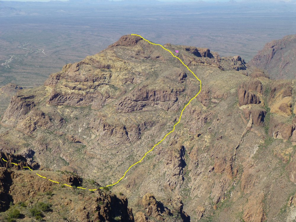
My route up Peak 4158
High up at the head of Arch Canyon sits Peak 4540. This is the third-highest peak in the entire range, and it’s another of the border peaks. Where we left off on our border journey earlier was atop Peak 3940. From there, you can follow the ridge south for a mile to reach MP8, then go another 0.8 of a mile and you will reach Peak 4540.
Another of the Arch Canyon peaks is Peak 4740. This lofty summit is the second-highest in the range. My route up it was a horrible bushwhack which I would not ever repeat. In the midst of that green thrashing, I found the remains of a young human female. Looming over that spot was this spectacular un-named spire.
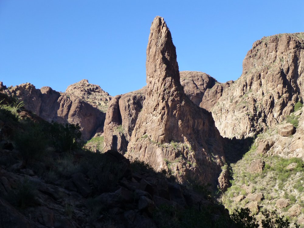
The spire
Let’s return to our border ridge once again. We last left off at Peak 4540. If we travel south from that peak, in half a mile we come to MP9. Next, following another 7/10ths of a mile brings us to Mount Ajo. At 4,808 feet, this is the paterfamilias of the entire Ajo Range. A benchmark by the name of Sierra del Ajo sits on the summit. This peak is understandably quite a draw – it has been climbed by many people, some of them several times. An excellent trail leads to the top.
Up to this point, the range has been characterized by deep canyons, huge cliffs and a lot of terrain that is not-much-traveled. This results in a lot of very wild country that offers safe haven to desert bighorn sheep. The wild nature of much of the Ajo Range also serves to allow the Mexican drug cartels to travel freely in the more remote parts of the range. If you’re going to venture very far from the few roads or off of the established trails with the intention of adventuring in the back-country of this range, you need to be well-prepared and skilled in such travel. Peakbaggers are among the few who have explored any of this wilderness.
I try to limit my posts to about 2,000 words, and since I’ve reached that now, I’ll continue with our journey in Part 2. I’ll see you soon.