
Please be sure to read Part 1 of the story before continuing here.
Hi Everyone – where we left off, we had been working our way south through the Ajo Range. I had discussed the peaks out on the Organ Pipe National Monument side of the range, as well as the “border peaks” which sat along the boundary between Organ Pipe on the west and the Tohono O’odham Indian Reservation on the east. We had made it all the way down to Mount Ajo, which turned out to be the highest peak in the range. There is a pretty decent trail all the way to the top of Mount Ajo. It starts at the Ajo Mountain Drive and climbs about 2,500 vertical feet to the summit. The views from the top are second-to-none. This peak is a big draw, attracting legions of hikers, peakbaggers and climbers every year.
Let’s leave it now and continue our journey south. If we drop down the ridge from the summit, we only need walk 1,400 feet until we reach Marker Post #10, which sits at 4,600 feet, the highest of all the boundary markers. Continuing another 1.2 miles along the ridge, we come to MP#11. This one also sits up high, at 4,300 feet. Perhaps it’s no coincidence that, for the most part, the marker posts are about 1.2 miles apart, as measured along the height-of-land – maybe that’s a distance that worked best for the surveyors. If we continue along the ridge to the next one, MP#12, we see that it is another 1.2 miles. The same applies as we travel to MP#13. Just beyond that marker, in fact only 800 feet later, we arrive at Peak 3465.
This is an interesting location – from the peak, the border drops down almost a thousand vertical feet in a mile to what is known as Sweetwater Pass. The elevation of the pass is exactly 2,523 feet. How do we know that? Well, MP#14 sits right at the pass, that’s why. I’ve been doing a lot of talking about these boundary markers, and now it’s time to show you one. You may need to zoom in on this photo to see the important details.
Some of it is easy to read – the outer ring says “U.S. General Land Office Survey”. The inner ring says “Penalty $250 for removal” – that would have been a big fine indeed back in 1929, equivalent to $4,435.00 today. But it’s the finer print that’s really important. There is a vertical line in the middle of this brass marker. On the left side of it we see the letters PL – that stands for “Public Land”. On the right side of the line we see “PIR 14M” – that stands for “Papago Indian Reservation”, which was the former name of the tribe and reservation. The 14M tells us that this is marker post 14. And at the bottom we see the year the survey was done, 1929. As the marker sits on its post in the ground, to the left of the line is the public land, while the reservation land sits to the right of the line.
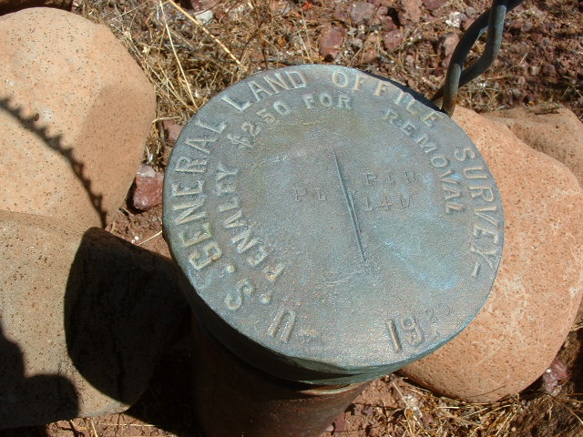
MP#14 at Sweetwater Pass
For many years I had wanted to visit Sweetwater Pass. My chance finally came on July 30th of 2005. It’s an interesting place – the land drops off to the west into Organ Pipe, but less so into the reservation on the east side. A couple of miles to the west, down in Organ Pipe, can be found Peak 2582. It sits there by itself, just to the east of Ajo Mountain Drive. It’s not much to look at, really.
From Sweetwater Pass, we get a great view of something special to the south, and here’s why it’s special. In the entire Ajo Range, there are but 4 peaks with names, plus one more with a named benchmark on its summit. Two of those named features sit together in plain sight from the pass. We’re approaching them now, and here’s what they look like. That’s Diaz Spire on the right and Diaz Peak on the left. We’ll catch up to them shortly.
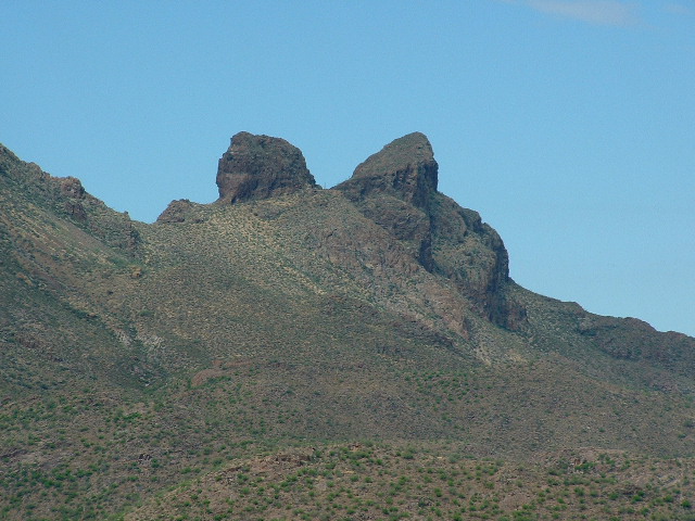
Both of the Diaz summits.
If we continue south along the boundary, we climb from 2,523 feet up to 3,126 feet at MP15, and that takes us, you guessed it, another 1.2 miles. From there, we continue our climb steeply uphill until, almost 1.1 miles later, we arrive at the summit of Diaz Peak, at 4,024 feet. This is a very prominent peak, visible from afar, and is understandably a big draw – not as much as Mount Ajo, because it’s harder to reach, but worth the effort. Most people who climb this peak also climb the nearby Diaz Spire. The Spire lies entirely within Organ Pipe Monument, whereas the Peak sits on the boundary.
There’s another peak nearby – in fact, it sits just 1,900 feet south of the Spire, but they are worlds apart. It is the little-known Peak 3704. I hesitated for years before going in to try this one, and if you look at the contours surrounding the summit, you can see that it is fiercely-guarded by a lot of steep cliffs. When I finally did go in, I spent hours playing cat-and-mouse with smugglers working for the drug cartels while deep in a remote canyon. Quite frankly, the whole business scared the shit out of me and I was mightily relieved when that day was over. If you click on this link, you can read my trip report.
Let’s move back over to the boundary and to Diaz Peak, then continue south along the ridge. It’s a short downhill jaunt to reach MP16, which still sits way up there at 3,832 feet. In order to reach the next marker to the south beyond 16, we need to drop steeply in that 1.2 miles. MP17 is all the way down to 2,705 feet. The ridge which serves as the boundary between Organ Pipe and the reservation twists and turns, constantly changing direction. Continuing from MP17, we travel another 1.2 miles before arriving at MP 18. This marker sits very close to the summit of Peak 3210, and there’s quite a story to tell you about this peak which I’ll leave until later. The marker itself sits at an elevation of 3,197 feet.
If we travel from MP18 to MP19 (another 1.2 miles), we find ourselves at an elevation of 2,801 feet. In another 0.4 mile, we arrive at Peak 3072, which I will discuss later on with Peak 3210. We need to move 0.8 mile farther to reach MP20. Once there, we realize that we’ve been following this boundary ridge for 24 miles, sticking to the height-of-land between Organ Pipe and the reservation. Now something quite different happens.
There is one more marker along the ridge, but instead of being numbered 21, it has no number at all. It sits at an elevation of 2,442 feet and is located 3,900 feet along the ridge from MP20. The Powers That Be, or at least the Powers That Were, decided that the boundary would no longer follow the ridge. We’ll come back to that later.
There are 2 small peaks sitting out in Organ Pipe, out by themselves. They are otherwise unremarkable, except for the fact that they are so bloody far away from everything. Peak 2194 is a mile north of Peak 2228. Getting to either of them requires a huge overland trek, which explains why they are never visited.
As we enter the southern end of the Ajo Range, we encounter something curious. A smaller, yet distinct, sub-range, known as the Sierra de Santa Rosa – it is clearly labeled on the topographic maps, yet it seems totally engulfed, surrounded if you will, by the much larger Ajo Range. In and of itself, it stretches about 9 miles north to south, all the way down to the Mexican border. It’s a curious thing, this range. It boasts a mere 3 peaks in all of its length. The northernmost sits only a mile from the end of the range, and it is known as Peak 2614. It’s a steep, loose thing, sitting out there by itself.
Two miles farther south along the spine of the range, we come to its highest point. Peak 2921 is a straightforward-enough climb, but the real problem is how are you going to get there? Fourteen people are known to have climbed it, but how some of them got there is shrouded in mystery. Its status as a range high point is the only reason so many people have made the effort to go there. There are only 2 legitimate ways to reach the mountain on foot.
The first way would be to come overland from the Ajo Mountain Drive which forms a loop through the eastern part of Organ Pipe Monument. I know of at least one party who came in that way. They did it as a backpack, traveling across the grain. From their camp in Ali Wua Pass, they climbed the north side of the peak. That would be a sensible way to approach and climb this peak if you had the luxury of time. It would require about 21 miles and about 2,000 feet of climbing.
The second way would be to walk east along the border road from near the border station at Lukeville, Arizona, for many miles, then head northeast across the desert making a beeline for the summit. This route would require a bit more than 31 miles and about 1,900 feet of climbing.
For the sake of completeness, I should mention a third way to approach and climb this range high point. You’re not allowed to do it, though. You could approach from the east, across the Indian reservation. There’s a road that runs 4.5 miles from pavement and ends up right below the peak. There’s no way you can get permission from the O’odham Nation to go in across their land – it’s just not going to happen. Back in 1998, during one of the wettest winters ever, a group of peakbaggers from California hired a fellow who lived on the reservation to act as their guide, thus giving an air of legitimacy to their presence there. In his presence, they climbed peaks all over the res. The night before their climb, on February 15th, in order to dry out themselves and their gear, they camped a short distance away from the paved highway and built an enormous bonfire. One of the fellows said that he was sure it “could be seen from outer space!” The next morning, they headed west the few miles and climbed the peak. There’s no way you’d be allowed to do that today, though.
That leads us to the last of the 3 peaks in this little range. One mile away from Peak 2921, the range high point, sits Peak 2721. Like the other 2 peaks in the range, it can be found along the main spine. For some reason, lookouts for the drug cartels are using this peak as a vantage point. Not just here, actually – the entire Sierra de Santa Rosa has been over-run. Nowadays, if you’re going to spend any time in there climbing, you need to be especially vigilant.
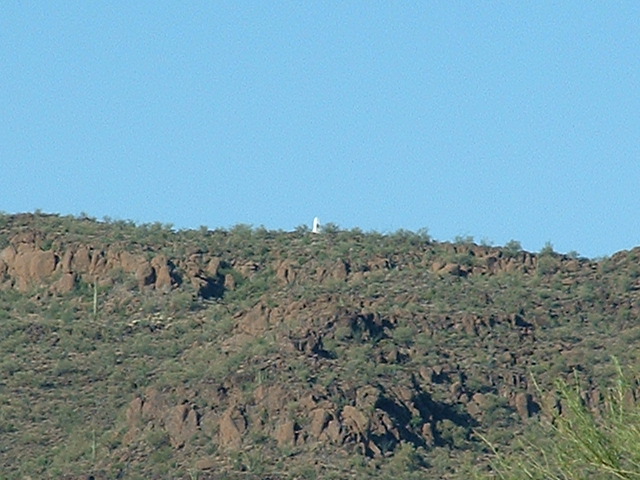
Let’s go back to the peaks along the boundary between Organ Pipe and the Indian reservation. Where we left off was at Point 2442 to the east of MP20. Up until now, the boundary has followed the height-of-land between the two jurisdictions. Now that all changes. We now head due south for 2 air miles, heading up and down over a couple of ridges, crossing through Ali Wua Pass, then up a valley. The boundary then makes an abrupt turn to the east for exactly one mile, in the process crossing over a ridge, down again, then up on to another to Point 2226. Now for the last hurrah. Our boundary plunges due south for 5.5 air miles all the way to the Mexican border, passing through the rest of the Sierra de Santa Rosa (and of course, also the Ajo Range, remember?). In those last miles, there are no more peaks either along the boundary or off to the west in Organ Pipe. I have one more picture to show you. Taken about one mile shy of the Mexican border, this photo looks up to the ridge where sits Border Monument 162, one of the very tall masonry type painted white. The edge of the Indian Reservation sits 800 feet off to the left of the #162 monument.
Well, even though we’ve reached Mexico, we’re not done yet. We haven’t discussed the 22 other peaks in the Ajo Range, the ones in the Indian Reservation. I’ve saved them for a final instalment of the story, so stay tuned for Part 3.