
In order to get the most from this piece, please be sure to read Parts 1 and 2 of “The Ajo Range” first.
If you’ve read the first 2 instalments of this story about the Ajo Range, you know that we discussed a total of 28 peaks: 25 of them were discussed under the label of Ajo Range peaks; 3 were discussed as Sierra de Santa Rosa Peaks. Also, 10 of those 28 fell into the category of “boundary” peaks because they were located along the height-of-land which separates Organ Pipe Cactus National Monument on the west from the Tohono O’odham Indian Reservation on the east. Now it’s time to move on from all of those and focus on a new batch of peaks that are located entirely within the TO reservation – there are 22 of those, so let’s get started.
Before we do, though, I need to clear up an important point. The Tohono O’odham Indian Reservation is a sovereign nation. That means that it is well over 4.3 million acres of private property. You cannot just go out there and climb mountains. If you do, you will be trespassing and therefore subject to fines and even arrest. Currently, the Nation does not give permits to travel off of the main highways crossing their land, and certainly not to engage in any back-country activities such as climbing. With one exception – Baboquivari Peak.
It wasn’t always that restrictive, though. Many years ago, I struck up a very positive relationship with a district chairman out there. Although he never asked for it, I made a series of donations to their district youth group. In return, he issued me a permit, year after year, which allowed me to travel the back roads and climb with impunity. I can’t tell you how many times I was stopped by U.S. Customs (that shows you how far back that was), the Border Patrol, the TO Rangers and the TO Police. I always showed them my permit, and even gave them a copy, with never a problem. So let’s continue with our discussion of the Ajo Range peaks on the TO Nation.
At the far northern end of the Ajo Range sits a tiny village, home to less than 10 people. It goes by the name Kuakutch (which is more properly known as Kuhkaj in the O’odham language). And here’s an interesting factoid for you – the name means “end of the mountain” in their language, very appropriate, as it certainly sits right at the end of the range. Alongside the village is a fence with this sign, marking the boundary between Organ Pipe and the reservation.
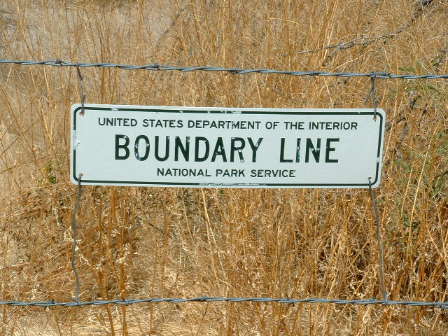
the marker beside the village.
The village of Kuakatch sits right at the western foot of Peak 2894. This is a steep mountain, quite striking and guarded by a lot of cliffs. Kuakatch Wash and Kuakatch Pass both sit on the south side of the peak.
Let’s follow the wash upstream to the south for 6 miles – that done, we arrive at a place called Barajita Well. It’s a lovely, quiet spot, surrounded by striking summits. The name Barajita is also used for the valley which lies to the east of the Ajo Range, running from near the Gunsight Hills in the north all the way to the site of the former community of Sweetwater in the south, and from the Ajo Range in the west to the Gu Vo Hills in the East, an area of almost 40 square miles.
Just 0.6 mile north of the well we find Peak 3542. A climb of 1,100 feet from the well, it’s the biggest of the peaks in that area. Close at hand to its southwest is Peak 3340. They both sit to the north of the well. Two more sit across the valley. Peak 3137 sits half a mile south of the well. Finally, Peak 2900 is east of the well and about 0.3 miles away. When you click on the link for Peak 2900, in the photo you will see the metal tank for storing water from Barajita Well.
Not far to the south of Barajita Well, but in another drainage, sits Tonoka Well. From this well, things drain east into what is known as Gu Vo Wash. An old road ends at the well, and this makes a good base from which to climb a trio of peaks. The highest, Peak 3380, sits only a mile away to the southwest, and it’s a thousand-foot climb. Also a mile away from the well can be found Peak 2942, which lies off to the southeast. At half that distance, but also to the southeast, rises Peak 2780. By road, it’s only 8 miles to the nearest settlement, but off by themselves as they are, the peaks surrounding these 2 wells feel much more remote.
A few short miles south of Tonoka Well, a road comes in from the east, from the village of Gu Vo. It ends right up at the base of the high peaks of the Ajo Range, and it was used by Andy Martin and me almost 20 years ago to access Peak 4540, one of the boundary peaks – in fact, it is the third-highest of the entire range.
When I think back on the peaks I climbed from the 2 wells, it’s easy to see that I was tempting fate (of course, hindsight is always 20-20, isn’t it?). They were done in May and June of 2005, and June is usually our hottest month). Came July, and it was just as hot. It was my habit to leave home at 2:00 or 3:00 AM, drive during the night, and be positioned to start climbing at first light. That way, I could take advantage of the coolest hours, and could get in a good 6 or 7 hours before noon. Even so, I had to be really careful, as it could easily hit 100° F. by as early as ten o’clock.
The road Andy and I used to get to Peak 4540 – there was a lesser road that headed south from it. On July 10th, I used it to gain access to Peak 3455, Peak 3220 and Peak 2860. Those peaks went well, and I was glad to get out of there in one piece.
Perhaps I was getting too cocky, because on July 23rd I was back. This time, I tackled Peak 3435 and Peak 2820. These required more distance to cover on foot to reach them, but things still went well. Hmmm, maybe I had unlocked some secret of climbing in hundred-degree heat. Inspired, I returned on July 30th, where I drove west along a road up Siovi Shuatak Wash. The first one I tried was Peak 2699. This one looked like trouble – I had been eyeing it from afar for weeks, and it looked steep on all sides. I walked around the summit block and decided to try the east side, which went at Class 4 on crappy rock. Just to the south of it sat Peak 2691, which went without a hitch. Two miles to the northwest was Peak 3262, the biggest one of the day, which also was easy.
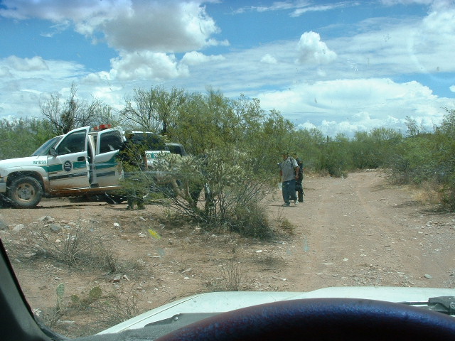
I had noticed from atop that third peak that the road I had been using continued to the west, and found I could drive on it all the way to Sweetwater Pass. (That’s where I found Boundary Marker 14). After I paid the pass a visit, I drove back down the road, and just south of Peak 2691 I saw some commotion ahead. Turns out it was 2 Border Patrol trucks and 3 agents who were arresting 2 indocumentados. We had a friendly chat and I continued east. I climbed one more peak on the way out, a small one in the nearby Gu Vo Hills.
Now on a roll, I returned about 2 weeks later, hoping to try my luck once again. I was able to climb both Peak 2774 and then Can Benchmark before the day grew too hot. These were done from the end of the road near the site of what used to be the settlement of Siovi Shuatak. Feeling pretty good about myself, I headed east and climbed 2 more peaks in the Gu Vo Hills. These hills run in a north-south band for a full 15 miles, and sit along the east side of the Barajita Valley which has been mentioned earlier in this piece.
After a 3-week break from the Ajo Range, I decided to return. It was August 28th, a date that will be clearly etched in my mind forever, and I’m about to tell you why that was the day the axe fell. There are so many reasons why I shouldn’t even have gone out there to climb that day, and so many poor choices I made – but once again, hindsight is always 20/20, right? First of all, I was in no condition to climb. I don’t mean that I wasn’t ready to put in the miles or the vertical footage, but it was something else. I had partied pretty hard the night before, having enjoyed too many adult beverages – as a result, the next morning I was already dehydrated. That’s a bad way to start a day for which they had forecasted a high temperature of 106°F.
There were 3 peaks I wanted to climb that day. For weeks, I had studied them from other nearby mountains, trying to figure out the best way to approach them. It turned out that there was no easy way, I would just have to put in a long day. Climbing all 3 of them in one big push made the most sense, so I could finally be done with them and wouldn’t have to return. I drove to the end of the road I’d used for Can Benchmark 3 weeks earlier and set out on foot before sunrise.
Even as I walked across the desert, fairly flat at this point, I felt out-of-sorts. I was starting out dehydrated, but wasn’t thinking clearly enough to realize it. For some reason on this hottest of days, I decided to travel light and was only carrying three 20-ounce bottles of Gatorade. How stupid – I should have had at least 3 times as much! I made it to the top of Peak 2750 and carried on down the other side, almost stepping on a western diamondback rattlesnake in the process. Once at the bottom, I was staring at a long slope with a climb of 900 feet to get me to the top of my next peak. Time seemed to crawl as I made my way to the top of Peak 3072 – it was 9:15 by the time I topped out, and almost 100 degrees. You know, I could have stopped at that point and headed back to my truck and the day would have turned out okay, but did I? Nope. I foolishly decided to continue along the winding ridge that was the border between Organ Pipe and the reservation.
It was a lot of up and down, and by the time I climbed up that last 600 vertical feet to the top of Peak 3210, I knew I was in trouble. I felt the first twinges of a leg cramp while on the summit, and had nothing left to drink. It was 3.5 miles from the mountaintop back to my truck, and my troubles were just starting. I’ve written an account of what happened next, and you can read all about it in the link below. Be warned, though, that what you’ll read is pretty gruesome and even troubling. If nothing else, let it serve as a lesson to others.
The week before I almost bought the farm climbing the 3 peaks discussed above, I had made a trip to the southernmost end of the range. On that day, I climbed Peak 2750 and also Peak 2150, both of which are close to the village of Ali Chuk (called Al Jeg in the O’odham language, meaning “little opening”). It is less than 2 miles to the Mexican border from Peak 2150. That day finished with a climb of Sweetwater Benchmark over in the Gu Vo Hills.
There remained only one last bit of unfinished business, and that was a climb of Peak 2473, just east of Ali Wua Pass. That was done on September 10th of 2005, along with 2 more peaks in the Gu Vo Hills. That was it, the dance was over – the 49 peaks of the Ajo Range had been completed. What a range! It has everything, from challenging technical summits to easy walk-ups; with as much wild, remote country as you could with for. I felt privileged to have been able to pull it off, with some important lessons learned. Thanks for coming along and keeping me company.