
Nigh on 30 years ago, I was sitting around home lamenting the hot weather – it was the dog days of summer. Hey, it’s a real thing. I looked it up on the Internet, and if it’s on the Internet, it must be true, right? It said that the dog days of summer, according to the Old Farmer’s Almanac, was the period of July 3rd to August 11th in the northern hemisphere. So I thought, why not get out of the desert heat for a few days and go climb some peaks in cooler places? Perhaps a few of the state high points I hadn’t done before. At the time, I was driving an Isuzu 2wd pickup with a shell on the back, simple but serviceable.
It wasn’t until 6:30 in the morning when I finally got away from Tucson, heading east on I-10. Arriving at El Paso without incident after 320 miles, I got myself on to U.S. Highway 180 and drove another 110 miles east through bare, open country. By the time I reached the headquarters of Guadalupe Mountains National Park, it was mid-afternoon. I had also lost an hour because of a time zone change, so when I started on foot at the trailhead it was already 3:38 PM. Even though the elevation was about 5,850 feet, I was surprised to see that it was a blistering 103 degrees, as hot as if I hadn’t even left Tucson! I followed an excellent trail which climbed quickly and entered patchy conifer forest. I met several other people en route and also saw 3 deer. It took me 2 hours and 10 minutes to cover the the 4.4 miles and 3,000 vertical feet to the summit of Guadalupe Peak, which at 8,749 feet was the highest point in Texas. It wasn’t what I expected – for some reason, I thought that because it was Texas, it’d be nothing to write home about. In actual fact, there were plenty of nearby peaks that were almost as high and quite impressive, and so were the views out in every direction. I spent half an hour on top and took this picture of a tall metal pyramid which stands on the summit. It has 3 sides, and each depicts something different. One side depicts the American Airlines logo. A second side depicts a US Postal Service 100th anniversary tribute of the Butterfield Overland Mail (1958) Pony Express riders who passed to the south of the mountain. A third side shows a compass with a logo of the Boy Scouts of America.
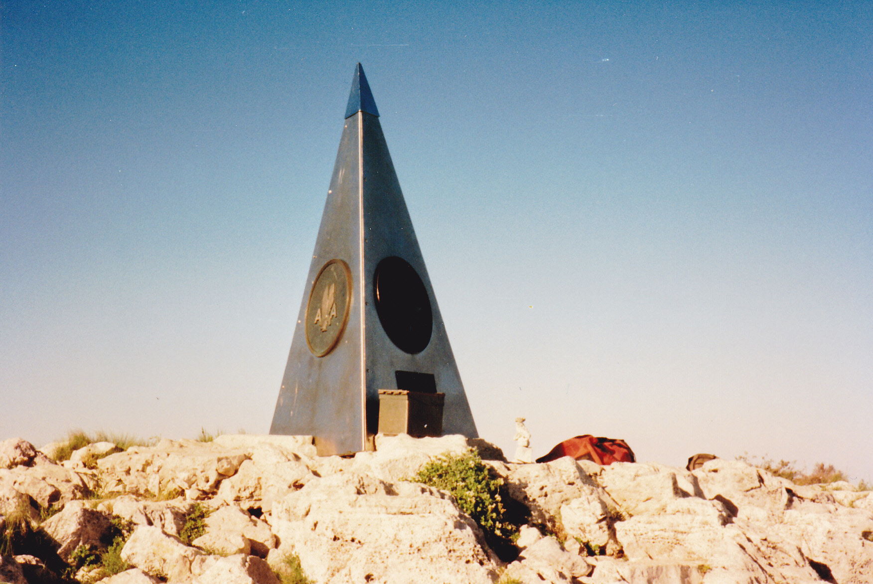
Monument on the summit
It was an easy hour and 50 minutes down with many stops to chat with others and take pictures, arriving back at the visitor center just before dark. Thankfully, the temperature had dropped all the way down to 75 degrees. The campground only allowed tent-camping, and I had left mine at home, so I had to move on. It took me half an hour of driving east in the dark before I found a spot where I could pull off the highway a bit and park for the night. Something I was quickly learning about this part of the country was that pretty much all of the land was privately owned, and the roads that led off from the highways were blocked by locked gates. All I could do was park a short distance from the highway and put up with the road noise of passing vehicles. It was okay, though, as I was tired enough that I slept well. It was impressive how dark the sky was. I was reminded of the song that said “The stars at night are big and bright, deep in the heart of Texas”. Those words certainly rang true.
From where I camped, I soon crossed back into New Mexico, passing the turnoff to Carlsbad Caverns. By the time I reached the town of Hobbs, I had reached the end of New Mexico – only 110 miles spent in the state before crossing back into Texas. Man oh man, this country was flat! There wasn’t anything to break up the monotony. I tried to do a little bird-watching through my windshield as I drove, but that was sketchy at best. I saw a few shrikes and quail, but one new bird I did identify for sure was the scissor-tailed flycatcher.
Once I entered Texas, I drove through towns like Seminole and Brownfield before arriving at Lubbock (I remember it had a nice classical station). Fifty miles north of Lubbock, I grabbed some fast-food lunch in Plainview, then motored on. Thirty or so miles north of Plainview it happened – officially, I became a panhandler. That is to say, I entered the Texas panhandle, that chunk of the state on its north end measuring about 200 miles by 200 miles. About 75 miles north of Plainview, I came to Amarillo, the only city of any size in the panhandle. Interstate 40 sweeps from west to east through Amarillo and the panhandle. I kept right on going, and passed through the small Texas towns of Dumas and Stratford. By the hamlet of Kerrick, I ceased to be a Texas panhandler and officially became an Oklahoma panhandler, and that was OK by me.
The Oklahoma panhandle is quite different from that of Texas. Although it is also 200 miles long, it is only 35 miles wide, so on the map it appears much more like a handle. When I entered the state at Kerrick, I angled over northwest to a place called Boise City, then went even further, to the extreme northwesternmost corner of the panhandle to a tiny place called Kenton. This was my destination, a full 500 miles from where I had camped from the night before. The landscape had changed dramatically – instead of the flat lands of Texas, I was surrounded by buttes and mesas.
I had with me a book called “Highpoints of the United States” which was filled with useful information on how to approach each of the state high points. It said to be sure to check in with the owners of the general store in Kenton. That wasn’t hard to do, as the town had a grand total of 5 inhabitants. They were most friendly and helpful, and knew all about high-pointers, having visited with many of them over the years. They gave me useful tips on how to reach the place where I should park to begin the walk up to the high point. I thanked them and made the short drive, parked, cooked a meal and settled in for the night. It had been a long day and I was glad to be done.
Early the next morning, I started out at a brisk pace. The Nature Conservancy had recently bought land here and the new route to the top of Black Mesa followed an old road along the north side, then up to the flat top and along it for a ways. In only 48 minutes I was standing at the high point of Oklahoma
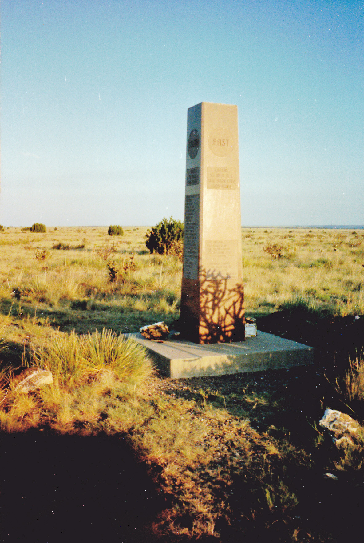
Black Mesa, elevation 4,973 feet
If it hadn’t been for the 9-foot granite monument, you’d never have known you were there. It’s like my old Dad used to say, the place was flatter than piss on a tin plate. There was nothing to do but turn around and head back down and drive back in to Kenton. It was still so early that nothing was open, so I just headed west out of town. Two miles later, I had crossed the state line and was in Colorado.
My truck was acting funny – I had no fan or air conditioner, and several warning lights wouldn’t go off. Heading west on Highway 456 into Colorado, I was making my way towards a place shown on my map called Folsom. My hope was that by the time I got there, in about 60 miles, maybe I could find a service station that could diagnose my problem and fix it. Imagine my surprise when I arrived and realized that it was practically a ghost town, a collection of hundred-year-old buildings and a few dozen inhabitants still hanging on. Sadly, there was no help to be found there.
I continued west on a lesser state highway, number 72, through uninhabited open country for another 40 miles. It was the shortest distance to reach the small city of Raton, situated on Interstate 25, where I figured there must be repairs available. At mid-day, I arrived and limped into a service station. Their mechanic looked under my hood and said that my alternator belt had broken. He didn’t have one that fit, but even though it was Sunday and parts stores were closed, he made a few phone calls and managed to come up with the right belt. The whole business took 4 hours to sort out, and the mechanic only charged me $36.00 for everything. What a guy! – he was really on my side, going above and beyond the call of duty, just trying to help out a traveler who was in a tight spot.
I grabbed a bite to eat at Mickey D’s, then headed out of town. It was a long, slow drive to cover the hundred miles to Taos, with winding roads and slow drivers. That was okay, though, my truck was working perfectly. Taos was so touristy. I drove right through, and then the remaining 20 miles up to Taos Ski Valley, which was even more touristy. There is a part of their parking lot which is set aside just for hikers near the campground, and that’s where I settled in for the night. Even though I had only driven about 220 miles for the day, it felt like a lot more, and I was glad to be done. I was parked at around 9,350 feet elevation and it was nice and cool, a very comfortable place to spend the night.
Very early the next morning, when it was still dark, I set out out from the parking lot. Opting to travel light with not even a day pack, I was doing what we used to call an anorak climb. Everything was in the pockets of my Gore-Tex jacket. I walked up a steep gravel road, and across a creek from me was a whole string of ski lodges. The road dwindled and became a trail through nice forest, where there were patches of snow. I reached Williams Lake at around 11,100 feet elevation, set in a basin surrounded by several peaks over 12,000 feet. The trail continued to the east from the lake up a steep slope for about 2,000 vertical feet. I saw lots of chipmunks, pikas and big, brown marmots that were really tame. The trail topped out on the summit ridge, and from there it was a short walk south to the summit of Wheeler Peak, elevation 13,161 feet, the high point of New Mexico.
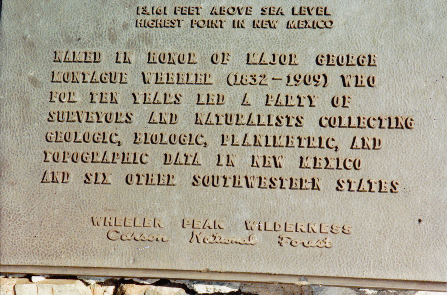
The plaque on the summit.
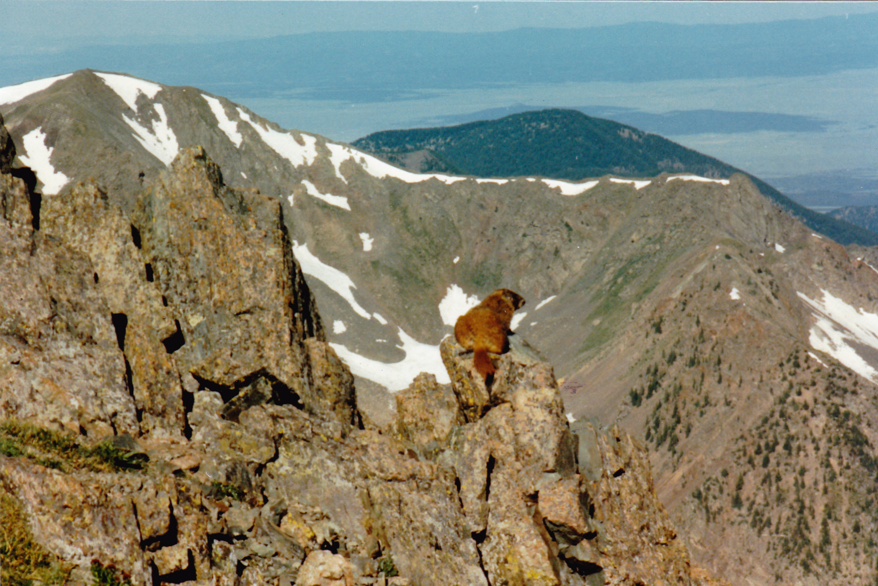
A very tame marmot.
This was a nice, high, cool summit. Of all the state high points in the US, only 7 were higher than this one, so it felt pretty good to be here. I lingered for a bit, then headed down the way I’d come up. Many people were coming up. By the time I’d covered the 8.5 miles round-trip back to my vehicle, 6 hours had passed. I put on fresh clothes and prepared for the drive home.
It was a short drive to Taos, which seemed like one big collection of art galleries. After looking around for a bit, I bought a nice piece of pottery for my wife Dottie, then left by around 2:00 PM. The drive to Santa Fe was along the Río Grande, where many rafters were floating along. With a full tank of gas, I joined Interstate 25 and headed south. The miles rolled by, past Albuquerque, Socorro, Truth or Consequences. I finally left the freeway when I came to the exit for state Highway 152, which I followed west for 33 miles until I reached Emory Pass. This was a spectacular spot in the Mimbres Mountains at 8,228 feet, a perfect spot to camp for the night. Although I had only driven 345 miles for the day, it felt like a lot more, probably because of the 3,900 feet of climbing done for Wheeler Peak.
After a good night’s sleep, I drove west and down through a lot of beautiful country to arrive at Silver City, where I spent a while looking around. From there, it was an easy drive to Lordsburg on Interstate 10 and then west for the last 180 miles to reach home. The trip had netted 3 state high points for me, spread over 5 days and 1,800 miles of driving. I had been able to call myself a panhandler for a couple of those days.