
Thielsen Buzz
In 1990 I was knocking off a few peaks up and down the west coast. Early one morning, I approached Mount Thielsen from the west, crossing the Pacific Crest Trail en route. When my friend and I got up high on the peak, we discovered we were not alone. The peak is really steep in its final moves on the rock leading to the summit. She and I made it up okay, unroped, but then realized that we had bitten off more than we could chew. The other party kindly offered us the security of their rope to help us down the trickiest bits. As all this was going on, clouds had moved in over the summit and we could hear claps of thunder too close for comfort. I remember hearing kind of a buzz building up, like an electrical charge. Luckily for us, we didn’t get hit by lightning, but we were all much relieved to scurry down the easier slopes below and get far away from Thielsen as quickly as we could.
El Canadiense
I was struggling up a steep path at around 14,000 feet. It was a perfect sunny day, and I was laboring under a heavy pack. From up above, I heard a voice shouting “El Canadiense” (The Canadian). The shout was repeated several times. I was too out-of-breath to reply, so I just sat and waited for the man to descend to me. It was Gustavo, who worked for Andesport out of Mendoza. We had last met when I was retreating from Aconcagua 10 months earlier (he was the one who kindly offered to carry my pack down the last 2,000 vertical feet to base camp). I was flattered that he remembered me. He even asked about my British friend Peter who had been stuck high up on the mountain with me. He was there guiding a group for Andesport this day, and as we would both be going back to Aconcagua soon, we agreed we would meet there again.
Fear
If you climb mountains, you are going to go up high – that’s the whole idea, right? And if you go up, of course you don’t want to fall back down. It seems logical that you wouldn’t be afraid of heights if you’re a climber, but the fear of falling is fundamental to all climbing. It doesn’t matter if you’re going for the summit of a mountain peak, climbing up a rock face, or making your way up steep ice as an ice climber. I don’t believe anyone who says that, as a climber, they have no fear of falling. If that’s true, they are neither brave nor sensible. Bravery lies in overcoming fear, not in being unafraid. A sensible climber has a respect for life. Fear, and the ability to recognize it and overcome it, are necessary to safely practice the art of climbing.
Zundapp
When I was in the city of Antigua, Guatemala in the summer of 1972, I saw this cool motorcycle. It looked old, and its owner happened to be sitting nearby. Since my first vehicle had been a motorcycle, it intrigued me. When I asked him about it, he said it was a 1951 Zundapp. I had never heard of such a brand, and he went on to explain that it was German. The name means “igniter”, and the company had produced detonators for weapons, as well as motorcycles.
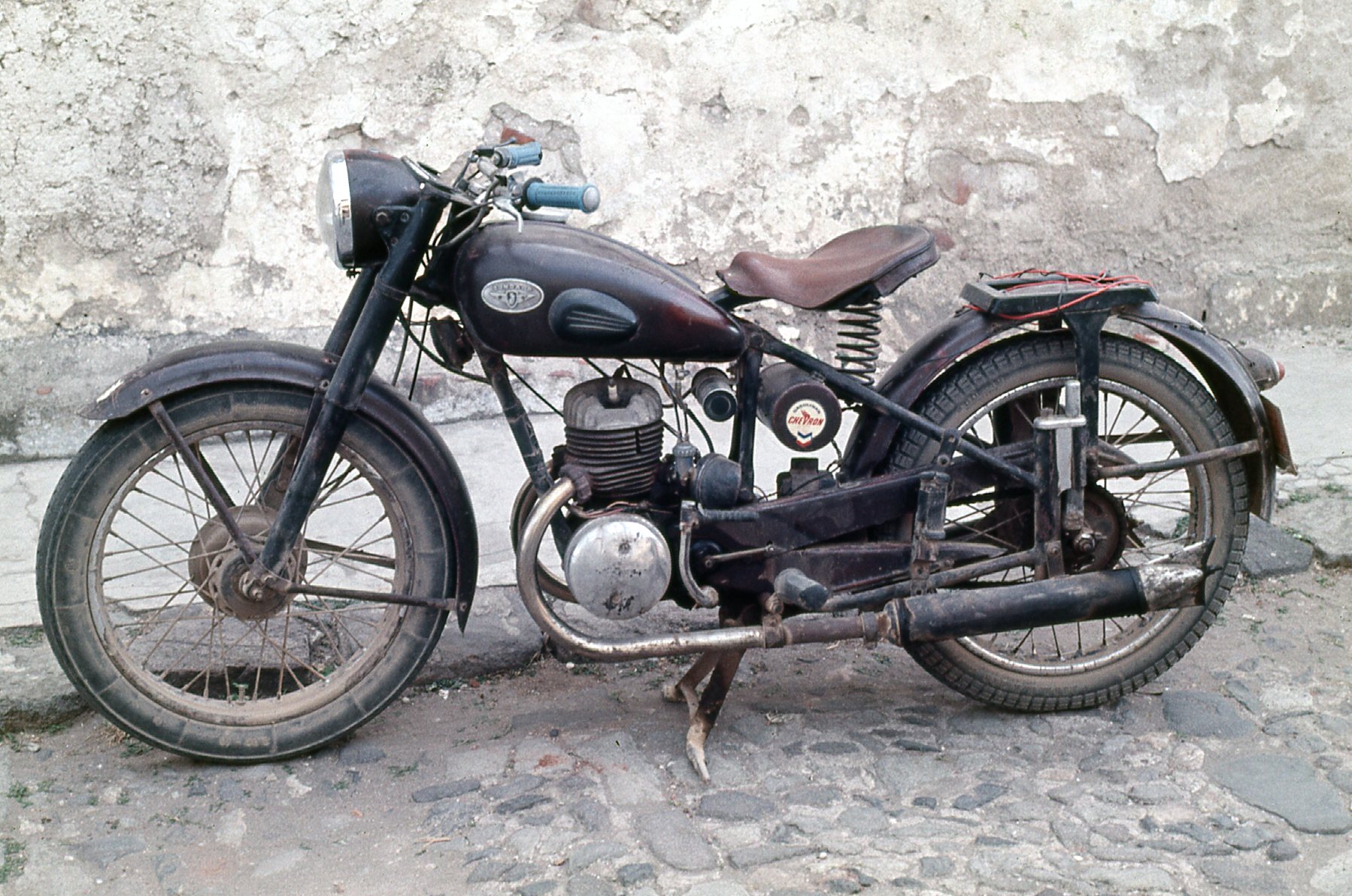
The 1951 Zundapp
Hoofline
One summer during the years I was in high school, I met a boy from another town and we got to talking about our teachers. He said a man who taught in his school had the last name of Hoofline. Now I’m not sure how it was spelled, but that’s how it was pronounced. You can probably guess that every kid in his school had given the poor guy the nickname of “Hoofline and Sinker”.
Water
When I lived in coastal British Columbia, there was water everywhere. By that, I mean that as climbers, we were never far from a water supply. With all that rainfall, every valley seemed to have creeks, rivers or ponds. We never had to worry about carrying much water with us, because it wouldn’t be far until the next source. Up high in alpine country, there was probably snow we could melt if there was no running water nearby. It was easy to take water for granted. As the years went by and more people frequented the hills, it became more necessary to filter or otherwise purify any water we drank.
When I moved to the States, and more specifically to the desert, that all changed. In my home state of Arizona, there are very few perennial sources of water. It’s possible to find the rare tinaja, or natural basin in sand or rock, where water can sit for a period of time. They tend to be far and few between, though, and can be unreliable. Bottom line – here in the desert, you need to carry all your water with you. It’s heavy, but there’s no way around it. Here, we never take water for granted when climbing.
Wrapped Vehicles
Have you ever seen a vehicle wrapped around a tree? I have, plenty of times, here in the desert. Why would I see such a thing here when you may have never seen one where you live? Well, the simple fact is this. Being as close as we are to the Mexican border, a lot of vehicles are stolen here in Arizona, taken to Mexico, then used to transport drugs or undocumented border-crossers back into the States. More often than you’d think, these drivers end up trying to flee from law enforcement. They go too fast over difficult roads, or even go off-road, then lose control and have an accident. What you see in this picture is too often the result. This truck went down a steep road, lost control, veered off the road and ended up slamming into a tree. Usually, the tree is stronger than the truck. This driver had 2 spare tires on rims, as well as a bicycle, in the back of the truck. He thought he was prepared for anything, but it turned out that he was just a lousy driver.
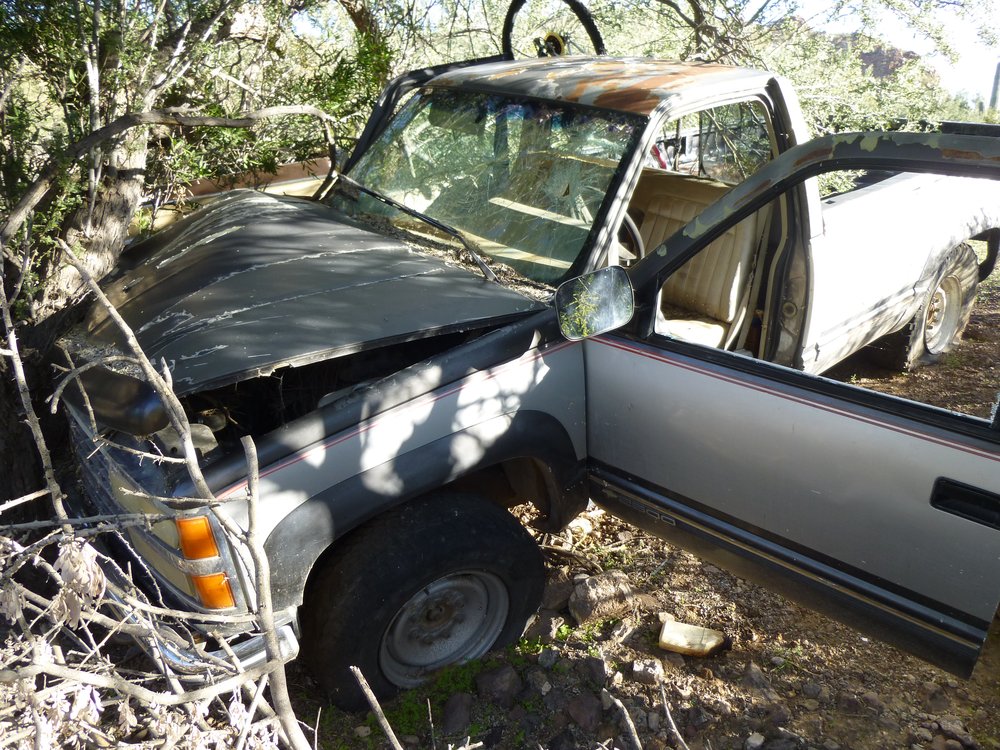
The truck
O’odham
In Arizona live a people who have been here for centuries, descended from the ancient Hohokam. They are the O’odham, and fall into 3 distinct groups. The Akimel O’odham, known as the River People, number about 14,000. They live south and east of Phoenix and have the Gila River Indian Reservation, about 584 square miles in area. The Tohono O’odham, known as the Desert People, number about 11,000. They live west of Tucson on the Tohono O’odham Indian Reservation, much larger at 4,341 square miles.
That brings us to the third group, the Hia C-ed O’odham. It is felt that they number about 1,000 but they have no land they can call home. Instead, they are widely scattered in communities like Ajo, Tucson and Phoenix. Tucson receives about 11 inches of rainfall a year and Phoenix gets 6. The Hia C-ed lived in an area bounded by the Ajo Range on the east, the Gila River on the north, the Colorado River on the west and the Gulf of California on the south. They were known as the Sand Dune People and their ancestral land was the harshest of all, receiving on average 3 inches of rainfall each year. They were a hunter-gatherer people and nomadic, having no villages to call home. They caught jackrabbits by chasing them down in the sand; they hunted bighorn sheep, mule deer and pronghorn antelope with bows and arrows. They caught muskrats and lizards, and sometimes went to the gulf to fish and gather salt. They also ate plants such as edible flowers, mesquite beans, saguaro fruit and pitaya.
Theirs must have been the harshest, the most challenging, existence of all. Most of the lands they inhabited were taken over by various government entities such as Organ Pipe Cactus National Monument, Cabeza Prieta National Wildlife Refuge and the Barry M. Goldwater Air Force Range. The U.S. government has never recognized them as a separate tribe. By 1900, they had mostly left their ancestral lands and intermarried with other O’odham and moved to towns such as Ajo, Gila Bend and Phoenix for work. I think it’s sad to think how a culture could lose so much of its identity in that way.
Heart Tank
Back in the 1980s, I headed out one winter to a remote area of the desert. In the 6 days I camped and climbed out there, I never saw one single person. It got cold at night – I found frost on the ground at 900 feet above sea level several mornings. At first light one of those mornings, I set out on an old track from the Tule Well road and headed east. Just over 9 long miles later, I arrived at the road’s end in a canyon. My goal was to climb the high point of the Sierra Pinta. It was a climb of about 2,000 feet, and it went without a hitch. Two things that stand out in my mind from that climb, though. As I was halfway down the mountain on my way out, a sandstorm erupted out on the desert floor and blew my way. When it hit, I hunkered down and covered my face with a bandana to filter out the dust as I breathed. Before long, the worst of it passed and I continued down. When I was about 300 feet above the desert floor, I stopped at a spot called Heart Tank. It was a natural depression in the rock, a tinaja, where rain water could collect. The Game and Fish Department had built it up a little so it could hold even more water for the wildlife. Desert travelers must have been using it as a water source for a long time, because scratched deeply into the granitic rock was “1895”. It was a long trek out those many miles to get back to my waiting pickup truck.
Deserts
Deserts – the state of Arizona has several. The Mojave Desert occupies a bit of the northwestern corner of the state, up where Nevada and California meet Arizona. The Great Basin Desert intrudes into the northeast corner in Navajo country. Some maps show that the Chihuahuan Desert occupies a bit of the southeast corner of the state. Geographers tell us those things, although you won’t really find the names shown on detailed topographic maps because those deserts occupy such vast areas.
By far the largest desert in Arizona, though, is the Sonoran Desert. Although we only have a small portion of this desert within our state boundaries (Mexico has the lion’s share, and California has a small piece), our share still occupies about 30% of the state, all of it in the southwest corner. There are 5 deserts whose names do actually show up on our maps, however. The Painted Desert lies in the northeast part of the state, much of it on Navajo lands – it’s a good size, about 7,500 square miles. The Tonopah Desert is small, about 30 miles long – it sits north of Interstate 10 and about 50 miles west of Phoenix.
Three more named deserts are to be found, all of them in the extreme southwest corner of the state. They are, from west to east: the Yuma Desert; the Lechuguilla Desert; the Tule Desert. These 3 are the harshest of deserts, where summer temperatures routinely exceed 110 degrees F. and annual rainfall is only 3 inches. They would most typify what many people think of when the word “desert” comes to mind. These three, along with the Tonopah Desert, are all a part of the Sonoran Desert.
Sonoran Pronghorn Antelope
This rare creature numbers only a few hundred, period. Some are in Arizona, the rest are in Sonora. I have been extremely fortunate to have seen them on 4 separate occasions. The first time was in February of 2014, when I saw one several hundred yards away in the southern part of the Granite Mountains, although it was a poor look. A few years later, 4 of them ran across the road right in front of me as I headed across open desert to the west of the Sauceda Mountains. It was a close but fleeting look. In 2019, I was approaching the Clanton Hills from the south and saw 3 of them off to my left as I drove. They kept pace with my truck for a mile or more. A month later, I saw what must have been the same ones in the same area – once again, they ran along with the truck, perhaps 200 feet away, for some distance before veering off and disappearing into the gathering gloom. Four sightings – how lucky can you get!