
Early in the year 2002, in the dead of winter, I got a call from my friend Dave Jurasevich in Los Angeles. He suggested that we get together and climb the highest points of some of the named sets of hills in Arizona. We were both on a kick of climbing hills highpoints anyway, we both had time on our hands and he was willing to make the trip out, so we agreed – it seemed like a good idea at the time. Dave’s a good organizer, and he arrived with maps in hand and some good ideas about possible routes we could use to climb the various peaks. We’d be making it up as we went, though, because we didn’t have any info about prior ascents, but that was okay – we were good at figuring out that sort of thing.
To get the journey started, we left Tucson on January 8th in 2 vehicles, his Toyota pickup and mine. Both were 4WD, so we knew we could tackle just about anything we might encounter. After 85 miles of travel on Interstate 10 and AZ Highway 80, we arrived at the legendary town of Tombstone. Quite the place, full of interesting history – if you’ve never been there and get a chance to go, do it. Because of the Gunfight at the OK Corral, the place is world- famous. The first thing we wanted to do was climb a few peaks near the town. For a starter, Dave chose the aptly-named Tombstone Hills. I should mention right now that I couldn’t even be writing this piece if it weren’t for the amazingly-detailed notes that Dave kept for each of these climbs and which he shared with me recently. At first blush, upon studying the topo maps, roads on the east side of the peak come fairly close, but those on the west are even closer. Dave had done plenty of research about possible driving routes to get close in to each of the peaks, and here’s what he came up with for the Tombstone Hills.
We drove to the edge of town and headed southwest on paved Old Charleston Road for 2.5 miles, then followed a series of ever-worsening dirt roads for another 3.3 miles, heading generally southeast. We parked at the end of a road at around 4,600 feet elevation. The drive in requires high clearance 2WD, or even better 4 WD. On foot, we headed east up a very brushy, loose slope, climbing up to a closed contour 5330. From there, another 0,4 miles ENE took us down to a saddle, then up to the true highpoint at 5,337 feet. This was a very brushy climb where long pants are needed. We found a register left by Mark Nichols – it was in poor shape, so we left a new glass jar and register book. His info from 10 years earlier, we also put into the new register. We returned to our trucks the same way. It was a gain of about 850 feet, with about 2 miles round-trip. Class 1-2. If you click on the blue link, you can see a picture of the peak. The Tombstone Hills are a fairly small group, about 7 miles long by 4 wide. Of the 8 peaks total in the group, fully 4 of them have names (The Dome; Uncle Sam Hill; Ajax Hill; Military Hill) – an inordinate amount for what you usually find in Arizona, mainly because of their proximity to Tombstone and its well-known history.
We drove back into Tombstone, then set out for our next peak. This time, we headed northwest out of town on what was called Schieffelin Monument Road. After 2.5 miles, we reached the monument itself.
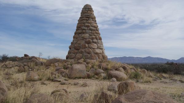
This was a tribute to a man who is considered the founder of the town of Tombstone. He died in 1897, only 49 years old. From the monument, we headed generally southwest for about 3 miles on dirt roads (high-clearance needed) and parked at the end of a road by a low concrete check dam. Our next peak was only 0.6 air miles away.
We were here to climb the high point of the Three Brothers Hills. Strangely enough, that point was also the high point of the Mays Hills. We climbed southeast up to a low saddle, a distance of only 0.3 miles. From there, we headed north along a ridge to Point 4810, not the high point but an interesting objective in its own right. We found a register there with entries from 1988 and 1989 – it was in poor condition so we replaced it with a new jar and register, but also added the old papers. An Immigration and Naturalization Service solar-powered repeater stood about 10 yards north of the summit. Getting here was the work of only 15 minutes from our parking spot. We then headed south along the ridge, over 2 intervening bumps and finally arrived at the rocky highpoint (Class 2) which is known as Peak 5144. We found no register, so left a new one in a glass jar. We found a benchmark stamped AJAX 1903. Records indicate that Mark Nichols had been to the summit a dozen years earlier. The round-trip stats were 950 feet of elevation gain, a distance of 1.8 miles and 2 hours total time. The Three Brothers Hills is a tiny group, only 3.2 miles long and containing only 2 peaks. The climb was pretty brushy and required long pants.
Back down at our vehicles, we headed back out. Dave and I are both licensed ham radio operators, and we kept in touch while driving by using our radios. There are certain protocols which are meant to be followed when talking between hams, but we were being rather casual and not using them. Another ham was listening in to our conversation and cut in to tell us that we needed to smarten up and be following proper procedures. Busted! So we smartened up and starting using our call signs from that point on. A bit embarrassing, though.
The day was wearing on, so before it got too late and we lost the light, we figured we’d better move on to be better placed for the next day’s climbing. We headed south to Bisbee, through town, then out toward Naco on Highway 92. I don’t remember where, but we camped out in the high desert that night in the back of our trucks, which was quite comfortable. The next morning, January 9th, we made our way to an area south of the Mule Mountains – our goal was the high point of the Naco Hills. We left the highway and, in less than a mile of driving on pretty decent dirt roads, we parked and got ready for the climb.
We couldn’t see the peak from our parking spot, but it wasn’t far, only 0.75 miles away at a bearing of 330 degrees. We walked a short distance up a 4WD road, then 0.4 miles NNW up a limestone slope to a closed contour of 5460 feet. From that point, the summit was visible to the NNW, protected by an impressive band of cliffs dropping down from the skyline ridge. There are 2 obvious breaks in the cliff band, one being a large chute about 0.1 miles east of the summit and one closer to the right end of the cliff face, where the height of the cliffs is greatly diminished. We continued 0.25 miles NNW to a saddle, and ended up taking the western break in the cliffs to the summit and descended the eastern one. It was a moderately brushy climb, where long pants are needed. Here is a link to the summit, called Naco Hills East, with an interpolated elevation of 5,780 feet. We found a summit register with 2 prior entries from 1990 and 1994. Round trip stats were: elevation gain – 1,250 feet; 2.2 miles; 2-3 hours total time, Class 2. The climb was fairly brushy and long pants were needed.
Back down to our vehicles, it was time to head to our next peak. We drove east through the town of Bisbee, then farther east into the Sulphur Springs Valley. This broad valley is about 95 miles long, stretching from the Mexican border near Douglas all the way north to where it meets Aravaipa Canyon. It is 20 to 25 miles wide and includes the towns of Douglas, Elfrida and Willcox as well as other small villages. It was a 60-mile drive to reach the Squaretop Hills, about 6 miles southeast of Sunizona. From Rucker Road, it was a short drive of 2.2 miles on a high-clearance 2WD dirt road to where we parked. The peak was clearly visible, only 0.7 miles away at a 280° bearing. About half an hour up a moderately-steep, fairly brush-free slope took us to the summit, called Flat Top Benchmark at 5,500 feet elevation. It was a climb of 900 feet, about 1.6 miles round-trip and Class 1-2. The Squaretop Hills is a small, tight group of 4-5 peaks.
With 2 climbs completed for the day (very short at this time of the year), we drove around until we found a bit of ground on which we could camp for the night. At an elevation of 4,200 feet with no firewood at hand, the best we could manage was to bundle up and sit in our folding chairs that evening. Man, it was cold! I remember calling one of our climber friends in California and telling them how we were freezing our asses off. They laughed and said that we were a couple of idiots, and reminded us that if we were looking for sympathy, we could find it between shit and syphilis in the dictionary.
The next morning, January 10th, we set out for our next objective. The Sulphur Hills are an irregular group of bumps about 6 miles northeast of the village of Sunsites, and the group is surrounded by privately-owned ranch land. We were lucky enough to get the permission of a landowner to cross his land and park close to the peak – from our parking spot, it was barely half a mile distant at a 229° bearing. We climbed southwest up a moderately-steep slope just left (east) of a prominent rock outcropping on the skyline ridge. We turned right and contoured along the base of the outcrop on its south side, regaining the ridge and following it to the highpoint (Peak 5165). It was an 800-foot elevation gain, 1.75 miles round-trip, about 1.5 hours in all, Class 1-2. We found a register on top with many entries, leading us to suspect that permission is regularly given by some landowner to cross their property to access the peak. Back down to our trucks the same way, it was time to move on.
Using state highways, we drove about 50 miles to the area of Fort Bowie, a National Historic Site tucked in between the Dos Cabezas Mountains and the Chiricahua Mountains, over on the eastern edge of the Sulphur Springs Valley. A few miles east of Apache Pass, we parked at a junction with a natural gas pipeline road. We hopped over a gate and walked 2 miles along the road, then turned south and in another 0.2 miles, stood atop Point 4460, the high point of the Emigrant Hills. Talk about an obscure spot – the only people on Planet Earth who would spend time getting atop this little hill would be hardened peakbaggers. We found no register, so left one. Records indicate that Mark Nichols had been there a dozen years earlier. There are 3 hills there that contour to the same elevation, but the easternmost one is the highest. It required 150 feet of elevation gain, 4.4 miles round trip, Class 1.
Two peaks done for the day, we found a place to camp for the night. One of the great things about Arizona is that so much of it is public land and camping is easy, unlike many other states where most of the land is private and off-limits. The next morning, January 11th, we drove to the town of Bowie. From there, via Interstate, then state highway and finally dirt roads, we ended up 22 miles later on the north side of the Fisher Hills. This is basically one ridge, 6 miles long, with only 2 summits and it is located 5 air miles northwest of Bowie. The last of the driving was 2WD high-clearance and then some 4WD, ending us up parked only 0.73 miles from the peak and to its north. We climbed to the south for a mile up a slope of increasing steepness to green, lichen-covered cliffs directly beneath the summit. There are breaks in the cliffs on the left (east) side of the cliffs (Class 2) or the cliff can be end-run along its east or west sides to reach the top (Class 1-2). We found a register in a glass bottle – the only entry was Andy Bates from March 4, 2001, but we know that Mark Nichols had been there 9 years before him. The high point was Peak 5005, and the stats for our climb were: 1,050 feet elevation gain; 2 miles, 2 hours, Class 1-2.
There was one more on the agenda. We drove through Willcox, then south to Kansas Settlement. From that area, we drove east on dirt roads, for a total of about 55 miles from where we’d climbed in the Fisher Hills. We now found ourselves out in the middle of the wide-open spaces of the Sulphur Springs Valley, and ended up at the Pat Hills. They were named after a man named Pat Bierne, who settled there in 1878 and ran cattle for many years. Nowadays, every inch of the area around the Pat Hills is privately-owned ranchland. Everywhere we drove, there were “No Trespassing” signs. Without any inside information, we had no choice but to do this one as a stealth climb. This is a small group of hills, only 4.5 miles long, with 3 actual peaks. The northernmost one we knew was the highest, so we set our sights on it. We climbed over a barbed-wire fence and headed ESE for 1.5 miles, crossing over 2 more barbed-wire fences en route. We climbed ESE up a clean slope to a rocky outcrop on the skyline ridge, then ENE along the ridge to the top. There, we found Benchmark Landmark 1935, but no register, so we left one in a glass jar. We knew one other climber had been there 9 years earlier. Round trip stats: 600 feet of elevation gain; 3.75 miles; 2 hours time; Class 1-2. If you click on this link, you can see a picture of the high point.
So, in a 4-day period we had climbed to the high points of 8 different groups of hills. Pleasant days, chilly nights. The driving was easy. Thanks to Dave’s route-finding, we managed to get in close to all of them. Private property was an issue in places, but nothing we couldn’t work around. All in all, a fun trip with a good friend. After the Pat Hills, we each went our separate ways back to our homes.