
For the last 50 years of my mountain climbing, I’ve always owned one vehicle or another that I could use to get in to the start of a climb. There were various pick-up trucks, and even a VW Beetle, but the best of them all, by far, were Toyotas trucks with the 4-cylinder 2.4-liter 22R engine. Such an amazing truck. I would beat the hell out of them trying to get as far in as I could. Plenty of times over the years, I confessed to my mechanic that I felt guilty how I treated them so badly, but he always said not to worry, that they were built to take a lot of punishment. I guess he was right, they never left me stranded. Today, I want to tell you about some of the most hair-raising roads I ever traveled.
Some roads leave an impression on you, even decades later, and those are ones I’d like to share with you. The earliest memory I have of a really bad road is from a climb we did in Ross Lillie’s 1977 Toyota Land Cruiser. It was brand new when we drove up a road in the Squamish River valley. The road got worse and worse, with a couple of creek crossings, and it became quite overgrown. Ross thrashed the Toyota up a thousand feet of gain before we called it quits. Even then, we had another 6,000 vertical feet of gain with full packs that day to camp below the top of Mount Cayley. We spent the night in a snowstorm well above tree-line and never did reach the summit. That was my first experience with a really bad road.

Packing up after a snowy night on Mount Cayley.
In the late 1970s, my only means of getting into the mountains to climb was in my old VW Beetle. With the engine over the rear drive wheels, it had really good traction. I drove some really bad roads in the Harrison Lake area, roads that my friend who owned a GMC Jimmy was always surprised to hear that I made it in so far. I beat the living hell out of that poor car on rough mountain roads until it finally died a tragic death.
In southwestern Arizona, there’s a huge tract of land called the Barry M. Goldwater Air Force Range. At 1.9 million acres, it is larger than the state of Connecticut, and some parts of it are rarely visited. I once had occasion to drive one of its roads that was highly memorable. The portion I’m thinking about started at a place called Pistol Pass. The road went northwest from there. One fine day in March of 2016, I drove that road in my old reliable Toyota 4×4. The bad stretch was just under a mile, but it was as unforgettable a stretch of road as you’d find anywhere. The road was littered with rocks – they were all over the road, so much so that you couldn’t avoid them. All you could do was bounce over them as you drove slowly, trying to avoid them (which was impossible). They shook both me and my truck badly. The road was badly overgrown with brush, and you could tell it wasn’t driven any more, even by the Border Patrol. That was one tough mile, and I was glad to finally arrive at the old corral.

The old corral at the north end of the mile.
The only denizens of that part of the desert were these lovely wild burros.
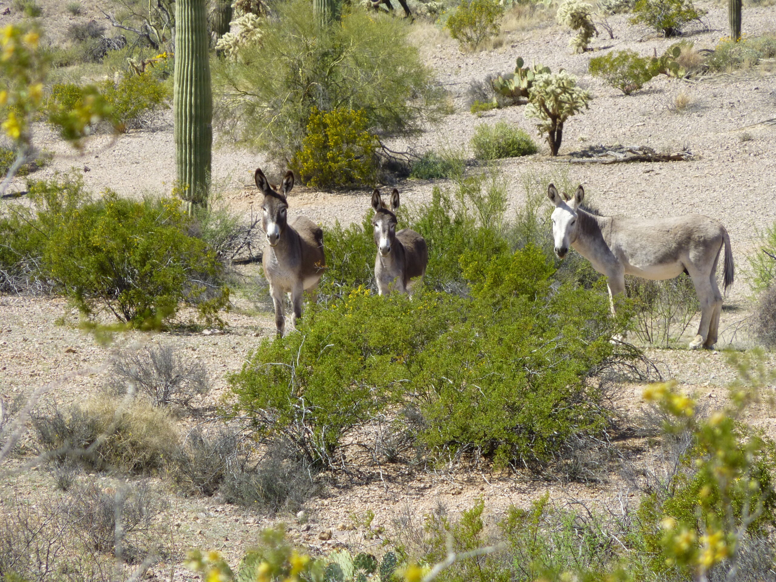
Wild burros.
Here’s one of my favorite bad roads, but it’s kind of a secret that I keep to myself. I’ve driven it a total of 4 times, in and back out again. I discovered it on my own many years ago, quite by accident. It starts at a place called Paradise Well, but even that name is long-forgotten and doesn’t appear on any modern maps. For the first mile and a half, the road is quite tame, its faint trace weaving its way through a cholla cactus forest, then up a wash for a ways. Then the fun begins. To escape the wash and continue, you have to power your way up a steep hill – it’s short, steep and loose, and even with my best gear-wrangling I’ve usually had to take several runs at it. Atop the hill, it levels out nicely for a short distance, but another challenge soon comes. It narrows, passing between a cliff on the left and a drop-off on the right, and even with the narrow stance of the Toyota, it’s a real nail-biter crawling through so you don’t drop off the edge on the right. Get through that, and the next part is easy. You soon arrive at a flattish spot, perfect for camping. You’ve now driven another mile. The road appears to end, but that’s an illusion. If you look around, you’ll see that it continues, dropping steeply down a canyon. It’d be drivable were it not for the washout right at the top of the canyon. Too bad – it’s nothing a back-hoe couldn’t fix in half an hour. I’ve walked it several times, and if it weren’t for that bad spot, you could drive down the canyon for another mile until it flattens out on the desert floor. This would unlock a long-forgotten and now-completely-unknown back door into the bombing range. I know I’ll never drive it again, but I’m not planning to tell anyone else about it either. It’s my little secret, and it’s too good to share.
Here’s another one for the ages. If you drive south down the Vekol Valley as far as South Vekol Well, then head southwest several more miles until you reach Peak 2723, you can leave that road and head west towards the road that comes south from Johnson Well. Before you get that far, though, the road goes to hell in a handbasket. The past 20 years have taken a terrible toll, and heavy rains have stripped the road right down to bedrock. It gets so rough that I had to drive it in low range in 1st gear. You could easily walk the last mile to the guzzler faster than you could drive it. The road continues from the guzzler uphill towards Bender Spring but you’ll never drive it. In 2 short switchbacks, it gains over 200 vertical feet, eroded down to bedrock. It now has a deep V down the middle of it, one of those roads that if you ever tried to drive up it and got either side of your vehicle into that V, you’d be so screwed.
The desert has a way of reclaiming roads if they remain untraveled. One of the best examples of such a road is one out in the Tank Mountains. We had been trespassing on the Yuma Proving Ground for a week when we decided to follow a road clearly shown on the topo map. It was already mid-afternoon when we found its start, but we figured it would only take us an hour or so, tops, to drive its length. However, it soon became obvious that that wasn’t going to be the case. The terrain was completely flat, so no hills or gullies to negotiate, but things soon went south. We wanted to drive a mere 2 miles before stopping for the night, but we had barely started along the road when we lost it. Using a map program on our cell phones, it appeared that we were right on top of it but we couldn’t see it. Getting out of our trucks, we walked around but couldn’t see any sign of the road. The ground was covered with a lot of rocks – it looked like they might have been dropped by a wash that the map showed had once been there, but there was no obvious trace of the wash either. We knew we were in the right place (the map program made certain of that). Deciding to continue, we pounded our way ahead over the rocks, but as time passed, we became more frustrated. Many times, we got out and looked around, but there was no trace of the road. Usually, there’s some sign – the faintest of tire tracks, or some ruts – the desert is fragile and can continue to show old tracks for many years after a road is no longer used. Several times, my partner was concerned that we were beating the hell out of our trucks because of all the rocks, but I urged that we continue. Finally, at dusk, we stopped on a bit of a rise. With 2 miles under our belts, we realized that there had been no trace whatsoever of our road. Gone, vanished, taken back by Mother Nature. Who knows how long it had been since it had been driven last? We didn’t take a single picture along that stretch, we were so frustrated and distracted.
One October some years ago, I spent a week driving roads in the Agua Dulce Mountains that were all closed to the public. One day, my companion and I were at the Mexican border and decided to drive north into the heart of the range. Our map clearly showed a road but we couldn’t see it on the ground. Turns out it hadn’t been driven in so long that the desert had wiped it clean. By using our GPS, we drove exactly to where the map said it should be. Nope, nothing. We took a chance and started driving north where it should be, and after several hundred yards found the faintest trace. Encouraged, we kept going and the road became more obvious and easier to follow.
After 2 miles, we could see that we were clearly on the road. It went through some open country, then at 3.4 miles a couple of mountain ridges squeezed us in from each side. Things changed in a hurry. The road now seemed to be in the bottom of a creek, or a wash as we call it here in the desert. It was tight, there was no way you could just drive out of the wash and on to the side, there wasn’t any other place to go. And now we found ourselves in the middle of a bad dream. The ground was littered with rocks, and they were everywhere. My friend had never driven with me through such trying terrain before that day, and it was a real eye-opener for both of us. You couldn’t steer your way around the rocks, there were just too many. All we could do was slowly, in my lowest 4wd gear, keep driving forward. All 4 wheels crept over every rock in their path, bouncing up and down over them, and the pounding was breath-taking. Please make it stop! It finally did, after about a mile. I was amazed that no parts had fallen off the truck. The rocks decreased, and beyond that mile we found ourselves camped for the night at Agua Dulce Pass.
Some of us have had the good fortune to drive the El Paso Natural Gas Pipeline road through the Tohono O’odham Indian Reservation. Just a few miles outside the res, to the west of it, the road drops steeply downhill in the Sauceda Mountains near Coffeepot Mountain. Perhaps it’s just a quirk of nature, or maybe the way rainwater runs off after a storm, but what used to be a decent road decades ago has turned into a nightmare. It’s just bedrock, and extremely rough at that. It’s so bad that the last time I drove it, downhill, crawling along in my lowest gear, the truck got twisted and jolted so badly that I was thrown up off of the driver’s seat, hitting my head on the roof of the cab and seeing stars. Anyone trying to drive uphill on that stretch better have a good 4wd and some good driving skills.
I’ve saved my best for the last. Without any doubt, the worst road I’ve driven in Arizona was something called the Dripping Springs Road. If you’ve ever driven it, you won’t soon forget it. It is out west near Yuma and it cuts through the northern end of the Gila Mountains in an east-west direction.
When I got back to my truck after climbing my first peak of the day, it was time for lunch. As I sat there in the shade, sucking down one of my remaining beers and enjoying some food, a rumbling sound was approaching. Before I knew it, 5 large quads pulled up and stopped in single file. The lead driver had his young son with him, and we started to talk. I told them that I was climbing in the area, and my plan was to continue east along the road, to drive all of it and come out on the other side of the range. He looked at my Toyota, doubt written all over his face, and said he didn’t think I’d make it. One of the other drivers came up, and the two of them agreed that the problem was not so much the steep, loose spots but rather the fact that the road was very narrow in spots and strewn with countless boulders. They stated that their quads had very high clearance (they did, even more so than my truck), but also really low gearing when needed, allowing them to crawl very slowly over obstacles. Their conclusion was that there was a slim chance I might make it, but it was gonna be a real challenge for me with that truck. By the way, they told me that they had all driven the road several times in the past, and I noticed that they were all wearing full-face helmets. All the while, I was thinking “How bad could it be? – I’ve driven some really horrific roads in the past and always made it through.”
They wished me well and drove away, leaving me pondering what awaited. I finished my lunch and packed up. With my transfer case in low range, I started out in second gear in 4WD, thinking “This isn’t so bad – in fact, it’s pretty good.” I spoke too soon. Within a hundred yards, I had gone around a bend and was shocked to see how rough the road ahead looked. Before I knew it, I was in my lowest gear and crawling along. There was a place or two where the road went into a wash, and the ground was so rocky that I couldn’t tell where it came out on the other side. At one particularly bad spot, I left the truck running and got out, walking ahead to find the road. When I did, I thought to myself “How in the hell can this be the road – nobody would drive this.” That was the first major obstacle – big rocks everywhere – I was shocked I made it through. Soon after that, while I was again walking ahead, I met up with all of the quads. The 2 from earlier were heading back down the road towards me, but had stopped and were talking to the five I had seen at lunch, who were still heading east uphill. They were a bit surprised to see I’d come that far, but cautioned me that it was gonna get a whole lot worse. That turned out to be an understatement. Did I mention the 3 wrecked vehicles I passed? Things hadn’t gone so well for those drivers.
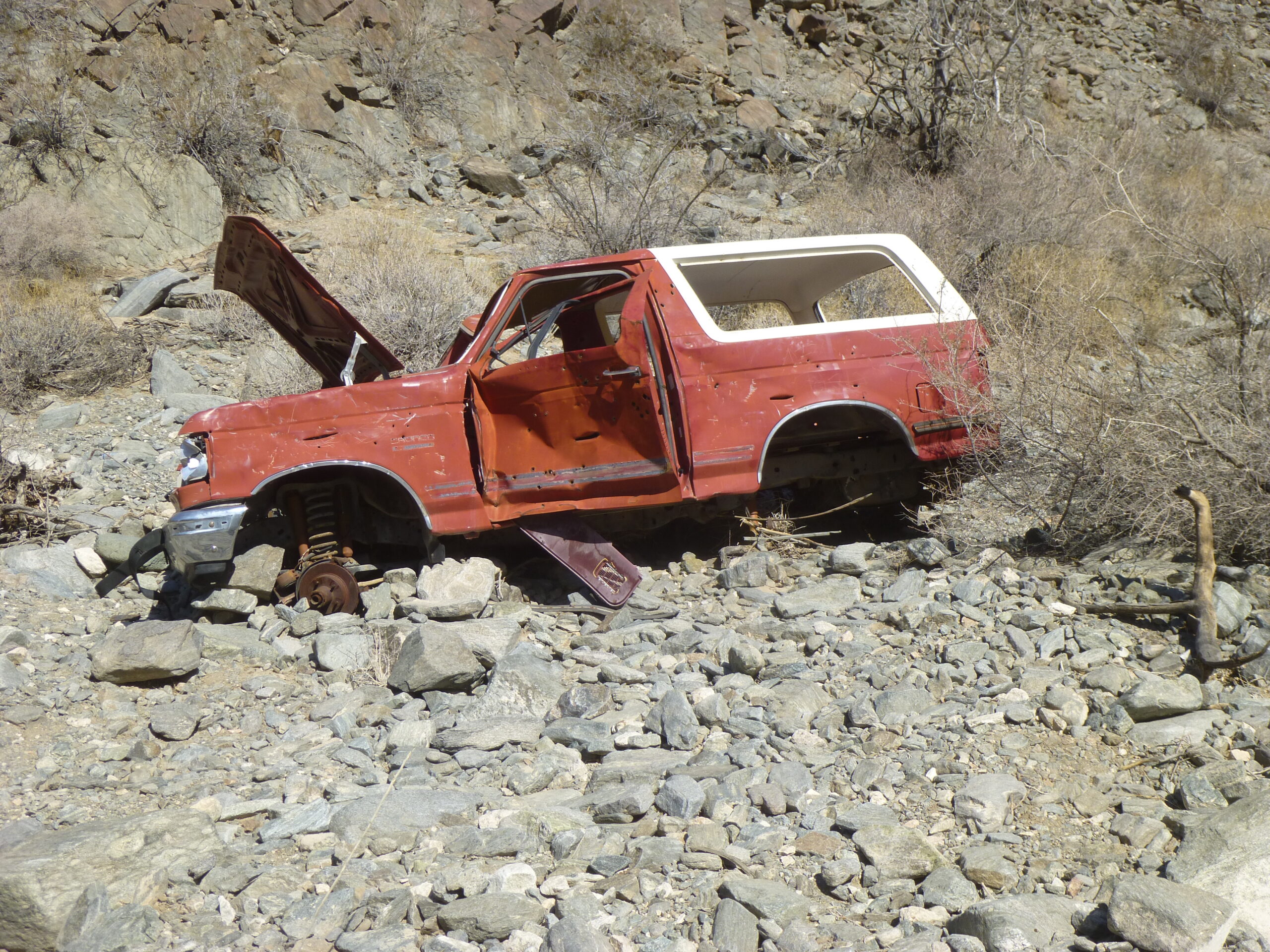
One of the wrecks by the wayside.
I couldn’t count the number of times I had to get out and carefully check the position of my wheels as I prepared to drive between big rocks – if off by even an inch sometimes, it would spell trouble. There were other times when, on one side or another, being in the wrong spot would have scraped the side of the truck along a rock wall or a huge boulder. It was slow, precarious going. Whenever possible, I would drive over rocks rather than between them, but that couldn’t always be done. It was clear to me now why all of the riders had been wearing helmets – if you’d been flipped out of your quad on some of this extreme ground, you’d crack your head open like an egg.
Finally, up ahead I saw the 5 quads stopped at a high spot – this turned out to be the pass that marked the greatest elevation along the road, about 1,100 feet above sea level. By the time I had driven up a couple of switchbacks to the pass, they had moved on down the other side. I got out and took a look around. It had been a real nail-biter up to this point, but I was encouraged that at least the rest of the drive would all be downhill. I’d have a gravity-assist, so it would have to be easier, right? Hah! No sooner had I started down the steep stretch from the pass than I realized that this was not going to be some pleasure cruise.
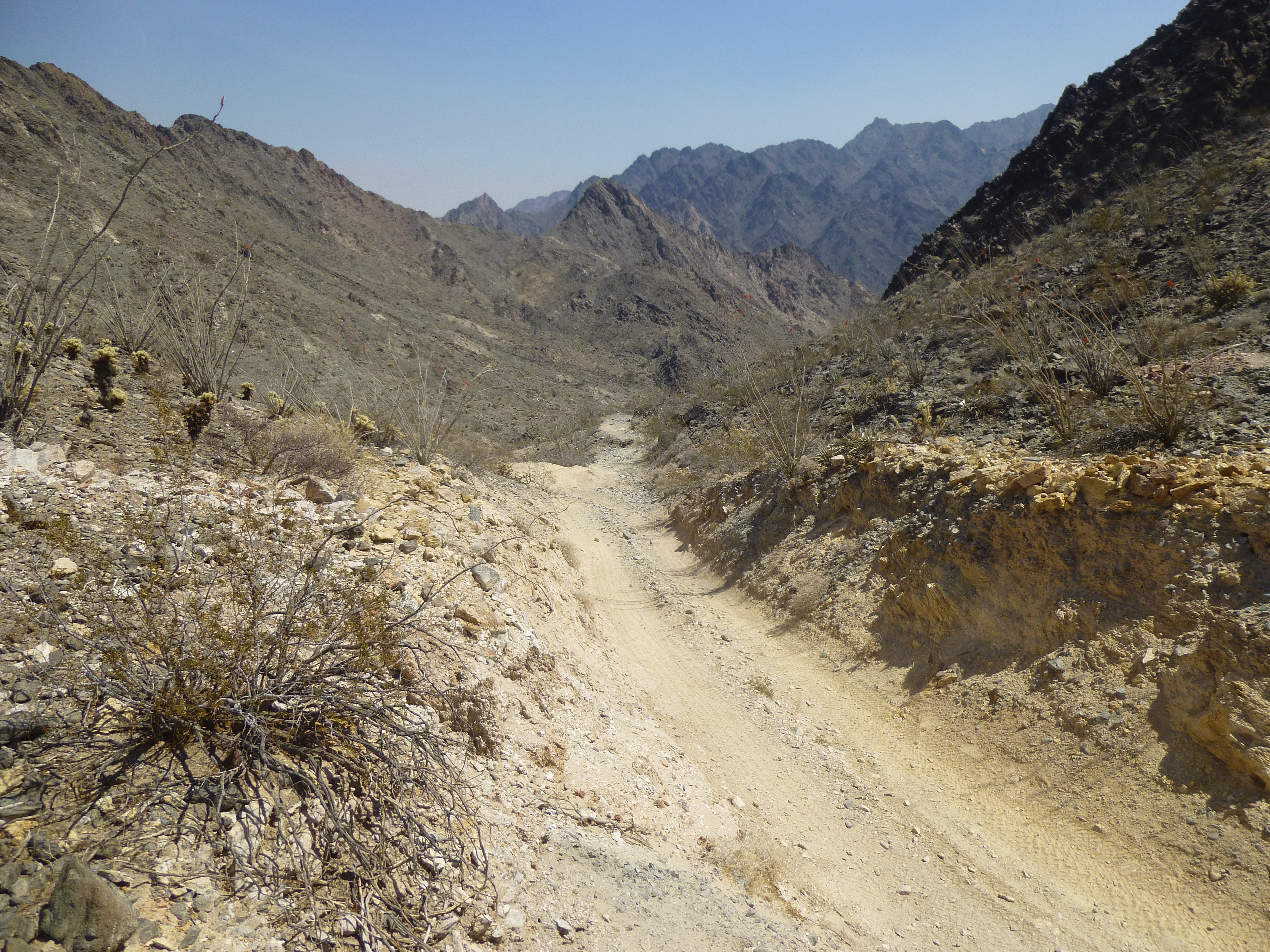
Looking downhill from the pass in the direction I was heading. It was smooth here, the rocks were just around the corner.
Now I was letting the truck crawl downhill in its lowest gear but riding the brakes constantly so I could manoeuver between the rocks. It didn’t take me long to conclude that you’d have to be delusional to consider the downhill portion any easier. If anything, it was more aggravating than the uphill portion to the pass had been. The downhill was much longer than the uphill. Again, there were places where the road seemed to disappear in the wilderness of rocks and I had to get out and walk ahead to make sure where it continued. Finally, the canyon opened up, and I was out! What a relief, like being paroled. There was no doubt in my mind that this was the toughest road I’d ever driven. Those guys driving the quads would have bet against me on making it through though.
So there you have it, Folks, some of my favorite rough roads. Like many climbers, I will try to push my way in as close as I can before I start a climb. However, some of those roads are so bad that you wonder if you should re-think that strategy! Thanks for coming along for the ride.